Ta'ãnga:Sarychev_Volcano_edit.jpg
From Wikipedia, the free encyclopedia
- Marandurenda
- Marandurenda rembiasakue
- Marandurenda jeporu
- Marandurenda jepuru opaite tembiapópe
- Apopyme'ẽ
Marandurenda moambue'ỹre (2734 × 2208 píxeles; tamaño de archivo: 551 kB; tipo MIME: image/jpeg)
Ko marandurenda haꞌehína Wikimedia Commons guive ha ikatu ojeipuru ambue tembiaporãme. Pe ñemombeꞌupy oĩva marandurenda ñemombeꞌupy kuatia ryepýpe ojehechauka koꞌápe.
Resumen
| Mombe'uangaSarychev Volcano edit.jpg |
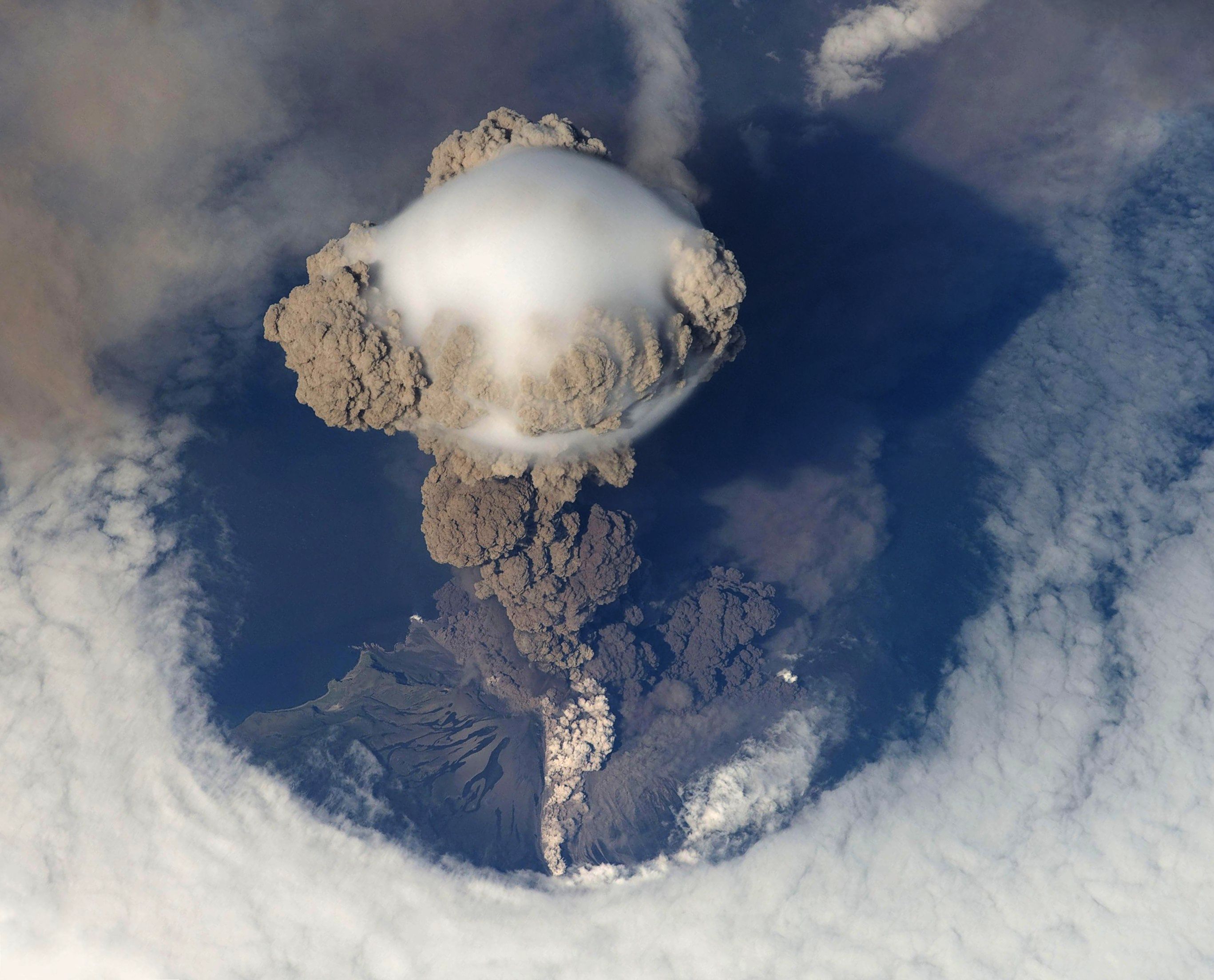
Čeština: Erupce sopky Saryčeva na ostrově Matua v Kurilských ostrovech. Fotografováno 12. června 2009 z Mezinárodní vesmírné stanice. Deutsch: Eruption des Vulkans Sarytschew am 12. Juni 2009. English: A picture of Russia's Sarychev Volcano, on Matua Island in the Kuril Islands, erupting on 12 June 2009, as seen from the International Space Station (ISS). The ISS orbits the Earth at a height of between 347 and 360 km. Original description by NASA: "Prior to June 12, the last explosive eruption had occurred in 1989 with eruptions in 1986, 1976, 1954 and 1946 also producing lava flows. Commercial airline flights were diverted from the region to minimize the danger of engine failures from ash intake. This detailed photograph is exciting to volcanologists because it captures several phenomena that occur during the earliest stages of an explosive volcanic eruption. "The main column is one of a series of plumes that rose above Matua Island (48.1 degrees north latitude and 153.2 degrees east longitude) on June 12. The plume appears to be a combination of brown ash and white steam. The vigorously rising plume gives the steam a bubble-like appearance; the surrounding atmosphere has been shoved up by the shock wave of the eruption. The smooth white cloud on top may be water condensation that resulted from rapid rising and cooling of the air mass above the ash column, and is probably a transient feature (the eruption plume is starting to punch through). The structure also indicates that little to no shearing winds were present at the time to disrupt the plume. By contrast, a cloud of denser, gray ash -- most probably a pyroclastic flow -- appears to be hugging the ground, descending from the volcano summit. The rising eruption plume casts a shadow to the northwest of the island (bottom center). Brown ash at a lower altitude of the atmosphere spreads out above the ground at upper right. Low-level stratus clouds approach Matua Island from the east, wrapping around the lower slopes of the volcano. Only about 1.5 kilometers of the coastline of Matua Island (upper center) can be seen beneath the clouds and ash."Français : Le volcan Sarychev, sur l'île Matua, en éruption. Photo prise le 12 juin 2009. 中文: 2009年6月12日萨雷切夫火山喷发情景。该火山位于千岛群岛中的马图阿岛。 |
| Arange | (UTC) |
| Moõgui oguenohẽ | |
| Apohára |
|
| Esta es una imagen retocada, lo que significa que ha sido alterada digitalmente de su versión original. Modificaciones: Rotated and cropped; empty corners filled in using smart replace filter; all darkened. La original se puede ver aquí: Sarychev Volcano.jpg. Las modificaciones las hizo Avenue.
|
|
Licencia
| Public domainPublic domainfalsefalse |
| Este archivo es de dominio público porque fue creado por la NASA. Las políticas sobre copyright de la NASA estipulan que «el material de la NASA no está protegido con copyright a menos que se indique lo contrario». (Políticas sobre copyright de la NASA o Políticas sobre la utilización de imágenes del Jet Propulsion Laboratory). | ||
 |
Advertencias:
|
And in case the retouching would attract a copyright:
| Public domainPublic domainfalsefalse |
| Yo, el titular de los derechos de autor de esta obra, lo libero al dominio público. Esto aplica en todo el mundo. En algunos países esto puede no ser legalmente factible; si ello ocurriese: Concedo a cualquier persona el derecho de usar este trabajo para cualquier propósito, sin ningún tipo de condición al menos que éstas sean requeridas por la ley. |
Registro original de carga
This image is a derivative work of the following images:
- File:Sarychev_Volcano.jpg licensed with PD-USGov-NASA
- 2009-06-26T18:01:12Z TonyBallioni 4288x2840 (627136 Bytes) {{Information |Description={{en|1=A picture of Russia's Sarychev Volcano, located in the Kuril Islands, erupting, ass seen from the International Space Station}} |Source=http://www.nasa.gov/multimedia/imagegallery/image_featu
Uploaded with derivativeFX
Leyendas
Elementos representados en este archivo
representa a español
2 jasypateĩ 2010
Marandurenda rembiasakue
Ejopy peteĩ ára/aravo rehe rehecha hag̃ua pe marandurenda ojehechaukaháicha upe jave.
| Ára/Aravo | Michĩháicha | Tuichakue | Puruhára | Jehaimombyky | |
|---|---|---|---|---|---|
| ko’ag̃agua | 13:54 2 jasypateĩ 2010 | | 2734 × 2208 (551 kB) | Avenue | Darken. |
| 13:53 2 jasypateĩ 2010 |  | 2734 × 2208 (510 kB) | Avenue | Fill in blank areas in upper right and lower left corners using GIMP's "Smart remove selection ..." filter. | |
| 13:46 2 jasypateĩ 2010 |  | 2734 × 2208 (725 kB) | Avenue | {{Information |Description={{en|1=A picture of Russia's Sarychev Volcano, located in the Kuril Islands, erupting, as seen from the International Space Station}} |Source=*File:Sarychev_Volcano.jpg |Date=2010-11-02 13:43 (UTC) |Author=*[[:File:Saryche |
Marandurenda jeporu
La siguiente página usa este archivo:
Marandurenda jepuru opaite tembiapópe
Ko'ã ambue wiki oipuru ko marandurenda:
- Jeporu bg.wikipedia.org rehe
- Jeporu cs.wikipedia.org rehe
- Jeporu en.wikipedia.org rehe
- Portal:Geography
- Portal:Geography/Featured picture
- Explosive eruption
- Portal:Earth sciences
- Matua (island)
- Portal:Geology
- Talk:Matua (island)
- User:Ceranthor/FPC
- Wikipedia:Featured pictures/Sciences/Geology
- Wikipedia:WikiProject Volcanoes/Content
- Wikipedia:Featured pictures thumbs/26
- Wikipedia:Featured picture candidates/Sarychev Peak
- Wikipedia:Featured picture candidates/December-2010
- Wikipedia:WikiProject Russia/History of Russia task force
- Wikipedia:WikiProject Russia/Physical geography of Russia task force
- User talk:Ceranthor/Archive 19
- Wikipedia:WikiProject Geology/Recognized content
- Wikipedia:Picture of the day/July 2012
- Template:POTD/2012-07-15
- Wikipedia:Main Page history/2012 July 15
- Wikipedia:WikiProject Russia/Recognized content
- Portal:Geography/Featured picture/10
- Wikipedia:WikiProject Geology/Automated list of recognized content
- Jeporu es.wikipedia.org rehe
- Jeporu fa.wikipedia.org rehe
- Jeporu fi.wikipedia.org rehe
- Jeporu he.wikivoyage.org rehe
- Jeporu id.wikipedia.org rehe
- Jeporu kk.wikipedia.org rehe
- Jeporu mk.wikipedia.org rehe
- Jeporu pa.wikipedia.org rehe
- Jeporu sv.wikipedia.org rehe
- Jeporu ur.wikipedia.org rehe
- Jeporu vi.wikipedia.org rehe
- Jeporu www.wikidata.org rehe
- Jeporu zh.wikipedia.org rehe
Apopyme'ẽ
Ko marandurenda oguereko marandu ambuéva, oiméne oñembojoapýva kámara térã escáner ojeporúvagui ojejapo térã oñemoha'anga hag̃ua.
Oñemoambuéramo ko marandurenda iñemohenda ypykuégui, ikatu oĩ sa'imi ndohechaukái hekopete pe marandurenda oñemoambuéva.
| _error | 0 |
|---|