Íomhá:BayofBengalTCNov1219700956UTCITOS1.png
From Wikipedia, the free encyclopedia
15B_1970-11-12_0956Z.png (342 × 394 picteilín, méid comhaid: 150 KB, cineál MIME: image/png)
| Seo comhad as An Cómhaoin Viciméid. Tá an tuairisc as an leathanach tuairisc Cómhaoin a leanas thíos.
|
Achoimriú
| Tuairisc15B 1970-11-12 0956Z.png |
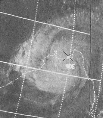
English: This ITOS 1 weather satellite image of the November 12, 1970 Bay of Bengal Tropical Cyclone was taken at 0956 UTC |
| Dáta | |
| Foinse | Mariners Weather Log, January 1971, pg. 19 |
| Údar | NOAA |
| Camera location | 21° 30′ 00″ N, 89° 30′ 00″ E | View this and other nearby images on: OpenStreetMap |
|---|
Ceadúnú
| Public domainPublic domainfalsefalse |
This image is in the public domain because it contains materials that originally came from the U.S. National Oceanic and Atmospheric Administration, taken or made as part of an employee's official duties.
العربية ∙ čeština ∙ Deutsch ∙ Zazaki ∙ English ∙ español ∙ eesti ∙ suomi ∙ français ∙ hrvatski ∙ magyar ∙ italiano ∙ 日本語 ∙ 한국어 ∙ македонски ∙ മലയാളം ∙ Plattdüütsch ∙ Nederlands ∙ polski ∙ português ∙ română ∙ русский ∙ sicilianu ∙ slovenščina ∙ Türkçe ∙ Tiếng Việt ∙ 简体中文 ∙ 繁體中文 ∙ +/− |
Original upload log
| Dáta/Am | Toisí | Úsáideoir | Nóta tráchta |
|---|---|---|---|
| 24 Márta 2013, 00:59:03 | 342 × 394 (152776 bytes) | Thegreatdr (plé · dréachtaí) | User created page with UploadWizard |
Captions
Items portrayed in this file
taispeánann sé/sí
23 Márta 2013
21°30'N, 89°30'E
media type Béarla
image/png
fb30bbe544f19f43768adfdd884e0af9ceb3a887
153,747 Beart
394 picteilín
342 picteilín
Stair chomhaid
Cliceáil ar dáta/am chun an comhad a radharc mar a bhí sé ag an am sin.
| Dáta/Am | Mionsamhail | Toisí | Úsáideoir | Nóta tráchta | |
|---|---|---|---|---|---|
| faoi láthair | 17:40, 23 Aibreán 2016 | | 342 × 394 (150 KB) | BMacZero | remove noise |
| 23:04, 23 Lúnasa 2014 |  | 342 × 394 (132 KB) | GifTagger | Bot: Converting file to superior PNG file. (Source: BayofBengalTCNov1219700956UTCITOS1.gif). This GIF was problematic due to non-greyscale color table. |
Úsáid comhaid
Tá nasc chuig an gcomhad seo ar na leathanaigh seo a leanas:
Global file usage
The following other wikis use this file:
- Úsáid ar ar.wikipedia.org
- Úsáid ar bn.wikipedia.org
- Úsáid ar ca.wikipedia.org
- Úsáid ar cs.wikipedia.org
- Úsáid ar el.wikipedia.org
- Úsáid ar en.wikipedia.org
- Úsáid ar es.wikipedia.org
- Úsáid ar eu.wikipedia.org
- Úsáid ar fa.wikipedia.org
- Úsáid ar fi.wikipedia.org
- Úsáid ar fr.wikipedia.org
- Úsáid ar he.wikipedia.org
- Úsáid ar hr.wikipedia.org
- Úsáid ar ml.wikipedia.org
- Úsáid ar my.wikipedia.org
- Úsáid ar oc.wikipedia.org
- Úsáid ar pt.wikipedia.org
- Úsáid ar ro.wikipedia.org
- Úsáid ar tr.wikipedia.org
- Úsáid ar ur.wikipedia.org
- Úsáid ar vi.wikipedia.org
- Úsáid ar www.wikidata.org
- Úsáid ar zh-yue.wikipedia.org
- Úsáid ar zh.wikipedia.org
Meiteasonraí
Tá breis eolais sa comhad seo, curtha, is dócha, as ceamara digiteach ná scanóir a chruthaigh ná a digitigh é.
Má tá an comhad mionathraithe as an bunleagan, b'fhéidir nach mbeidh ceann de na sonraí fágtha sa comhad atá athruithe.
| Taifeach íomhá i dtreo an leithid | 28.35 dpc |
|---|---|
| Taifeach íomhá i dtreo an airde | 28.35 dpc |