Ofbyld:Verbreitungsgebiet_der_Tataren.PNG
From Wikipedia, the free encyclopedia
Oarspronklik bestân (1.077 × 384 pixels, bestânsgrutte: 13 KB, MIME-type: image/png)
Dit bestân komt fan Wikimedia Commons, en kin ek troch oare projekten brûkt wurde. De beskriuwing op syn bestânsside dêre wurdt hjirûnder werjûn.

|
This ethnographic map image could be re-created using vector graphics as an SVG file. This has several advantages; see Commons:Media for cleanup for more information. If an SVG form of this image is available, please upload it and afterwards replace this template with
{{vector version available|new image name}}.
It is recommended to name the SVG file “Verbreitungsgebiet der Tataren.svg”—then the template Vector version available (or Vva) does not need the new image name parameter. |
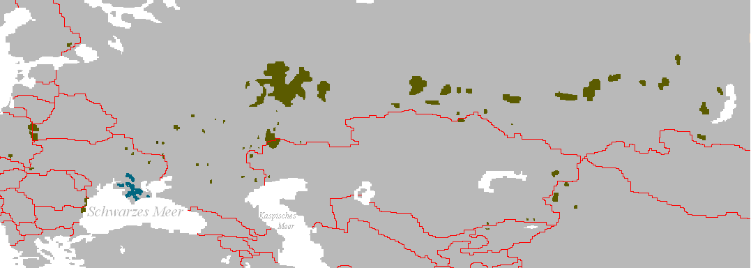
Verbreitungsgebiet der Turko-Tataren
- Beschreibung: Darstellungskarte mit den Siedlungsgebieten jener Völker, die sich heute als „Tataren“ bezeichnen bzw. sich von diesen herführen.
- Zeichner: Postmann Michael
- erstellt am: 13. Februar 2005
| Public domainPublic domainfalsefalse |
| |
This work has been released into the public domain by its author, Postmann Michael, at the Ingelsk Wikipedy project. This applies worldwide. In case this is not legally possible: |
Captions
Items portrayed in this file
depicts Ingelsk
Triemskiednis
Klik op in datum/tiid om it bestân te besjen sa't it op dat stuit wie.
| Datum/Tiid | Miniatuer | ôfmjittings | Meidogger | Opmerking | |
|---|---|---|---|---|---|
| lêste | 3 jun 2024, 17.56 | 1.077 × 384 (13 KB) | Sakaiberian | Reverted to version as of 08:36, 10 July 2017 (UTC) | |
| 26 mai 2024, 15.15 | 1.077 × 384 (10 KB) | SteinsplitterBot | Bot: Image rotated by 180° | ||
| 10 jul 2017, 10.36 | 1.077 × 384 (13 KB) | Szczureq | Restored Crimean Tatars, with different coloring. | ||
| 8 nov 2011, 22.52 | 1.077 × 384 (25 KB) | Glossologist | Removed Crimean Tatars, which are a separate Turkic ethnic group. | ||
| 8 mrt 2006, 21.15 | 1.077 × 384 (22 KB) | Robert Weemeyer | Verbreitungsgebiet der Turko-Tataren * Beschreibung: Darstellungskarte mit den Siedlungsgebieten jener Völker, die sich heute als „Tataren“ bezeichen bzw. sich von diesen herführen. * Zeichner: Postmann Michael * erstellt am: 13. Februar 2005 {{PD |
Bestânsgebrûk
De neikommende side brûkt dit bestân:
Globaal bestânsgebrûk
De neikommende oare wiki's brûke dit bestân:
- Gebrûk op af.wikipedia.org
- Gebrûk op als.wikipedia.org
- Gebrûk op an.wikipedia.org
- Gebrûk op bs.wikipedia.org
- Gebrûk op ca.wikipedia.org
- Gebrûk op cs.wikipedia.org
- Gebrûk op da.wikipedia.org
- Gebrûk op de.wikipedia.org
- Gebrûk op en.wikipedia.org
- Gebrûk op en.wikiquote.org
- Gebrûk op eo.wikipedia.org
- Gebrûk op fa.wikipedia.org
- Gebrûk op frr.wikipedia.org
- Gebrûk op fr.wikipedia.org
- Gebrûk op ga.wikipedia.org
- Gebrûk op gl.wikipedia.org
- Gebrûk op got.wikipedia.org
- Gebrûk op hr.wikipedia.org
- Gebrûk op hr.wikiquote.org
- Gebrûk op hu.wikipedia.org
- Gebrûk op la.wikipedia.org
- Gebrûk op lt.wikipedia.org
- Gebrûk op lv.wikipedia.org
- Gebrûk op mn.wikipedia.org
- Gebrûk op my.wikipedia.org
- Gebrûk op nl.wikipedia.org
- Gebrûk op oc.wikipedia.org
- Gebrûk op pl.wikipedia.org
- Gebrûk op sk.wikipedia.org
- Gebrûk op stq.wikipedia.org
- Gebrûk op su.wikipedia.org
- Gebrûk op sv.wikipedia.org
- Gebrûk op tk.wikipedia.org
- Gebrûk op zh.wikipedia.org
Metadata
Dit bestân befettet oanfoljende ynformaasje, dy't troch in fotokamera, scanner of fotobewurkingsprogramma tafoege wêze kin. As it bestân oanpast is, komme de details mûglik net folslein oerien mei de feroare ôfbylding.
| Horizontale resolúsje | 28,35 dpc |
|---|---|
| Fertikale resolúsje | 28,35 dpc |
| Datum/tiid bestânswiziging | 10 jul 2017, 08.35 |