Fichier:Scythian_capital_and_royal_kurgans.png
De Wikipedia, l'encyclopédie encyclopedia
Pas de plus haute résolution disponible.
Scythian_capital_and_royal_kurgans.png (489 × 424 pixels, taille du fichier : 23 kio, type MIME : image/png)
Ce fichier et sa description proviennent de Wikimedia Commons.
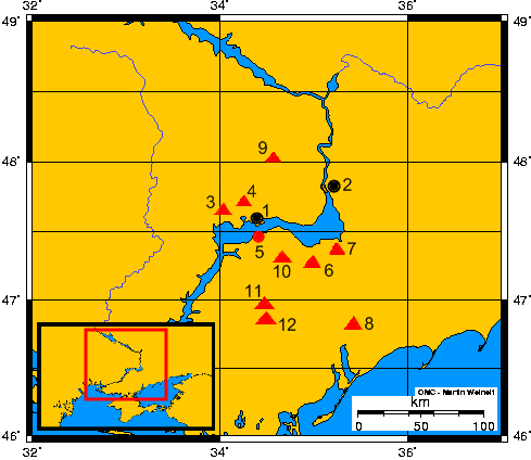
- Opis mapy - Description of the map:
- 1) Nikopol (współczesne miasto/modern town)
- 2) Zaporoże (współczesne miasto) - Zaporizhia (modern town)
- 3) Tołstaja Mogiła (kurhan) - Towstaya Mogila (kurgan)
- 4) Czertomłyk (kurhan) - Chertomlyk (kurgan)
- 5) Grodzisko Kamienskoje – Kamienskoye settlement
- 6) Sołocha (kurhan) – Solokha (kurgan)
- 7) Gajmanowa Mogiła (kurhan) - Gaymanova Mogila
- 8) Kurhan Melitopolski - Melitopol's kurgan
- 9) Kurhan Aleksandropolski - Alexandropol's kurgan
- 10) Bolszaja Cymbałka (kurhan) - Bolshaya Tsymbalka (kurgan)
- 11) Kozieł (kurhan) - Kozel (kurgan)
- 12) Oguz (kurhan) - Oguz (kurgan)
- 1) Nikopol (współczesne miasto/modern town)
| DescriptionScythian capital and royal kurgans.png |
English: Ancient scythian town-capital Kamienskoje and so-called royal scytians kurgans on grounds of the Lower Dnieper
Español: La antigua ciudad – capital Kamienskoie y así llamados real kurganos de escitas al curso bajo del Río Dniéper
Polski: Starożytne miasto–stolica Kamienskoje i tzw. królewskie kurhany scytyjskie nad dolnym Dnieprem
Русский: Каменское городище-столица Скифии и так называемые царские курганы Скифии в нижнем течении Днепра |
||
| Date | 10-12.11.2007 | ||
| Source | Travail personnel; on the basis of maps from historical books and WWW | ||
| Auteur | Janmad | ||
| Autorisation (Réutilisation de ce fichier) |
Moi, en tant que détenteur des droits d’auteur sur cette œuvre, je la publie sous les licences suivantes :
Ce fichier est disponible selon les termes de la licence Creative Commons Attribution 3.0 Non transposée.
Vous pouvez choisir l’une de ces licences. |

Légendes
Ajoutez en une ligne la description de ce que représente ce fichier
Éléments décrits dans ce fichier
dépeint
Valeur sans élément de Wikidata
Historique du fichier
Cliquer sur une date et heure pour voir le fichier tel qu'il était à ce moment-là.
| Date et heure | Vignette | Dimensions | Utilisateur | Commentaire | |
|---|---|---|---|---|---|
| actuel | 12 novembre 2007 à 18:29 | | 489 × 424 (23 kio) | Janmad | *Opis mapy-Description of the map:<br> **1)Nikopol (<br> **2)Zaporoże - Zaporizhia<br> **3)Tołstaja Mogiła (kurhan) - Towstaya Mogila (kurgan)<br> **4)Czertomłyk (kurhan) - Chertomlyk (kurgan)<br> **5)Grodzisko Kamienskoje – Kamienskoye settlement<b |
Utilisation du fichier
Les 3 pages suivantes utilisent ce fichier :
Usage global du fichier
Les autres wikis suivants utilisent ce fichier :
- Utilisation sur be.wikipedia.org
- Utilisation sur de.wikipedia.org
- Utilisation sur en.wikipedia.org
- Utilisation sur es.wikipedia.org
- Utilisation sur fi.wikipedia.org
- Utilisation sur pl.wikipedia.org
- Utilisation sur ru.wikipedia.org
- Utilisation sur uk.wikipedia.org
- Utilisation sur www.wikidata.org
Ce document provient de « https://fr.wikipedia.org/wiki/Fichier:Scythian_capital_and_royal_kurgans.png ».