Fichier:Aksai_Chin_Sino-Indian_border_map.png
De Wikipedia, l'encyclopédie encyclopedia
Fichier d’origine (624 × 872 pixels, taille du fichier : 102 kio, type MIME : image/png)
Ce fichier et sa description proviennent de Wikimedia Commons.
Description


| DescriptionAksai Chin Sino-Indian border map.png |
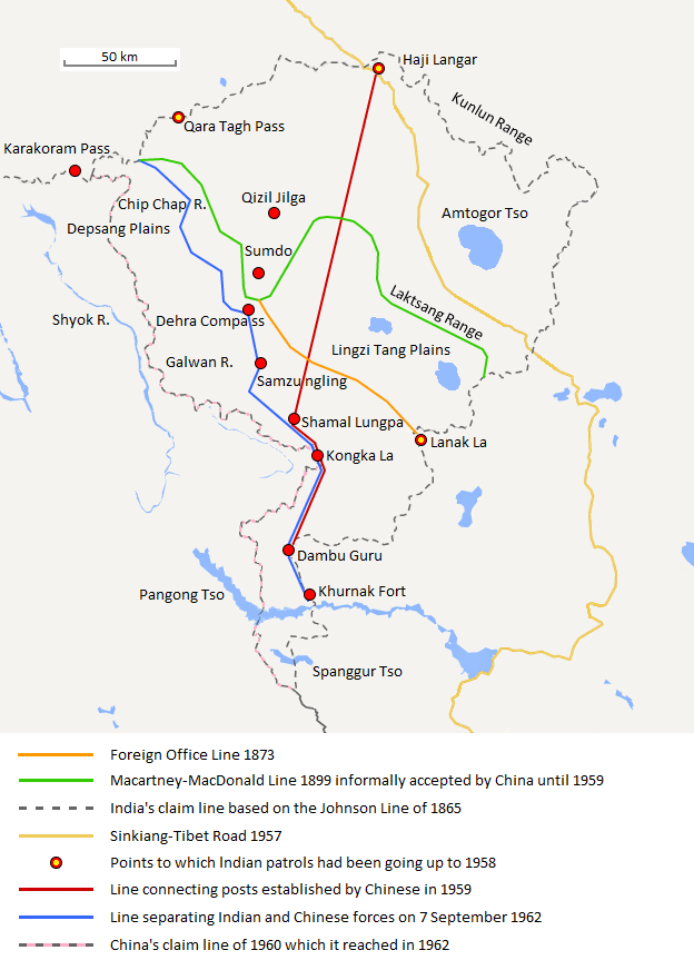
English: The map shows the Indian and Chinese claims of the border in the Aksai Chin region, the Macartney-MacDonald line, the Foreign Office Line, as well as the progress of Chinese forces as they occupied areas during the Sino-Indian War. |
| Date | |
| Source | Travail personnel |
| Auteur | The Discoverer |
The Macartney-MacDonald line is described as follows: "From the Karakoram Pass the crests of the range run nearly east for about half a degree, and then turn south to a little below the 35th parallel.. Rounding... the source of the Karakash, the line of hills to be followed runs north-east to a point east of Kizil Jilga and from there, in a south-easterly direction, follows the Lak Tsung (Lokzhung) Range until that meets a spur.. which has hitherto been shown on our maps as the eastern boundary of Ladakh.[1]
The Macartney-MacDonald line was never accepted by China, although they informally indicated acceptance on certain occasions:
- Woodman, Dorothy (1969) Himalayan Frontiers: A Political Review of British, Chinese, Indian, and Russian Rivalries, Praeger, p. 102 « The proposed boundary seems never to have been considered in the same form again until Alastair Lamb revived it in 1964. »
- Lamb, Alastair (1965). "Treaties, Maps and the Western Sector of the Sino-Indian Boundary Dispute". The Australian Year Book of International Law. "Unfortunately, the Chinese never replied formally to the note, though they indicated informally on a number of occasions their agreement as to its boundary alignment."
In 1959, Chou confirmed the new Chinese claim line to Nehru.
References: [2] copie d'archive sur Wayback Machine [3] [4] [5] [6] Map on last page copie d'archive sur Wayback Machine [7]
Conditions d’utilisation
- Vous êtes libre :
- de partager – de copier, distribuer et transmettre cette œuvre
- d’adapter – de modifier cette œuvre
- Sous les conditions suivantes :
- paternité – Vous devez donner les informations appropriées concernant l'auteur, fournir un lien vers la licence et indiquer si des modifications ont été faites. Vous pouvez faire cela par tout moyen raisonnable, mais en aucune façon suggérant que l’auteur vous soutient ou approuve l’utilisation que vous en faites.
- partage à l’identique – Si vous modifiez, transformez, ou vous basez sur cette œuvre, vous devez distribuer votre contribution sous la même licence ou une licence compatible avec celle de l’original.
Légendes
Éléments décrits dans ce fichier
dépeint
Valeur sans élément de Wikidata
27 août 2013
image/png
f6428074bd2a63fcdca4d1c78d6e29848885a399
104 131 octet
872 pixel
624 pixel
Historique du fichier
Cliquer sur une date et heure pour voir le fichier tel qu'il était à ce moment-là.
| Date et heure | Vignette | Dimensions | Utilisateur | Commentaire | |
|---|---|---|---|---|---|
| actuel | 7 septembre 2020 à 22:06 | | 624 × 872 (102 kio) | The Discoverer | Removed Tibet-Sinkiang boundary, added label for Amtogor Tso. |
| 9 juin 2020 à 04:51 |  | 624 × 872 (102 kio) | MarkH21 | Intended change from the last edit (i.e. latest version with "informally" per references in talk discussion) | |
| 9 juin 2020 à 04:29 |  | 624 × 872 (101 kio) | MarkH21 | Reverted to version as of 00:21, 7 February 2018 (UTC) This was the previous version; the addition of “accepted by China until 1959” was the contested change, not the revert to the original description (the refs are also now dead, but previously said tacit acceptance which isn’t outright acceptance) | |
| 23 avril 2018 à 21:37 |  | 624 × 872 (102 kio) | The Discoverer | Reverted to version as of 09:10, 13 December 2017 (UTC) The file of 12 December removes a statement that is supported by the source. As per COM:OVERWRITE, "Controversial or contested changes should be uploaded to a separate filename" | |
| 7 février 2018 à 02:21 |  | 624 × 872 (101 kio) | 樂號 | Reverted to version as of 23:05, 12 December 2017 (UTC) | |
| 13 décembre 2017 à 11:10 |  | 624 × 872 (102 kio) | The Discoverer | Reverted to version as of 11:07, 19 February 2017 (UTC) The file of 12 December removes a statement that is supported by the source. As per COM:OVERWRITE, "Controversial or contested changes should be uploaded to a separate filename" | |
| 13 décembre 2017 à 01:05 |  | 624 × 872 (101 kio) | 樂號 | Macartney–MacDonald Line is only proposed by Britain No official accept made by China | |
| 19 février 2017 à 13:07 |  | 624 × 872 (102 kio) | The Discoverer | Added Karakoram Pass and Kunlun Range | |
| 1 avril 2015 à 17:26 |  | 624 × 872 (59 kio) | RokerHRO | optipng -o7 -i0 → 40.77% decrease | |
| 2 octobre 2014 à 17:00 |  | 624 × 872 (99 kio) | The Discoverer | Uploaded correct file with scale added. |
Utilisation du fichier
Les 2 pages suivantes utilisent ce fichier :
Usage global du fichier
Les autres wikis suivants utilisent ce fichier :
- Utilisation sur ast.wikipedia.org
- Utilisation sur as.wikipedia.org
- Utilisation sur az.wikipedia.org
- Utilisation sur bh.wikipedia.org
- Utilisation sur bn.wikipedia.org
- Utilisation sur ca.wikipedia.org
- Utilisation sur de.wikipedia.org
- Utilisation sur en.wikipedia.org
- Utilisation sur es.wikipedia.org
- Utilisation sur hi.wikipedia.org
- Utilisation sur id.wikipedia.org
- Utilisation sur it.wikipedia.org
- Utilisation sur ja.wikipedia.org
- Utilisation sur ka.wikipedia.org
- Utilisation sur kn.wikipedia.org
- Utilisation sur ko.wikipedia.org
- Utilisation sur lv.wikipedia.org
- Utilisation sur ml.wikipedia.org
- Utilisation sur ms.wikipedia.org
- Utilisation sur nl.wikipedia.org
- Utilisation sur no.wikipedia.org
- Utilisation sur or.wikipedia.org
- Utilisation sur pl.wikipedia.org
- Utilisation sur pt.wikipedia.org
- Utilisation sur ro.wikipedia.org
- Utilisation sur ru.wikipedia.org
- Utilisation sur ru.wikinews.org
- Utilisation sur sr.wikipedia.org
- Utilisation sur ta.wikipedia.org
- Utilisation sur te.wikipedia.org
- Utilisation sur uk.wikipedia.org
- Utilisation sur vi.wikipedia.org
- Utilisation sur zh.wikipedia.org
Voir davantage sur l’utilisation globale de ce fichier.
Métadonnées
Ce fichier contient des informations supplémentaires, probablement ajoutées par l'appareil photo numérique ou le numériseur utilisé pour le créer.
Si le fichier a été modifié depuis son état original, certains détails peuvent ne pas refléter entièrement l'image modifiée.
| Résolution horizontale | 37,8 pt/cm |
|---|---|
| Résolution verticale | 37,8 pt/cm |