Mynd:Norwegian_Sea_map_no.png
From Wikipedia, the free encyclopedia
Stødd av hesi forskoðan: 657 × 600 pixels. Aðrar upploysnir: 263 × 240 pixels | 526 × 480 pixels | 1.000 × 913 pixels.
Upprunafíla (1.000 × 913 pixel, stødd fílu: 406 KB, MIME-slag: image/png)
Henda fíla er frá Wikimedia Commons og kann verða brúka í øðrum verkætlanum. Frágreiðingin á fílu frágreiðingar síðu er víst her niðanfyri.
| FrágreiðingNorwegian Sea map no.png |
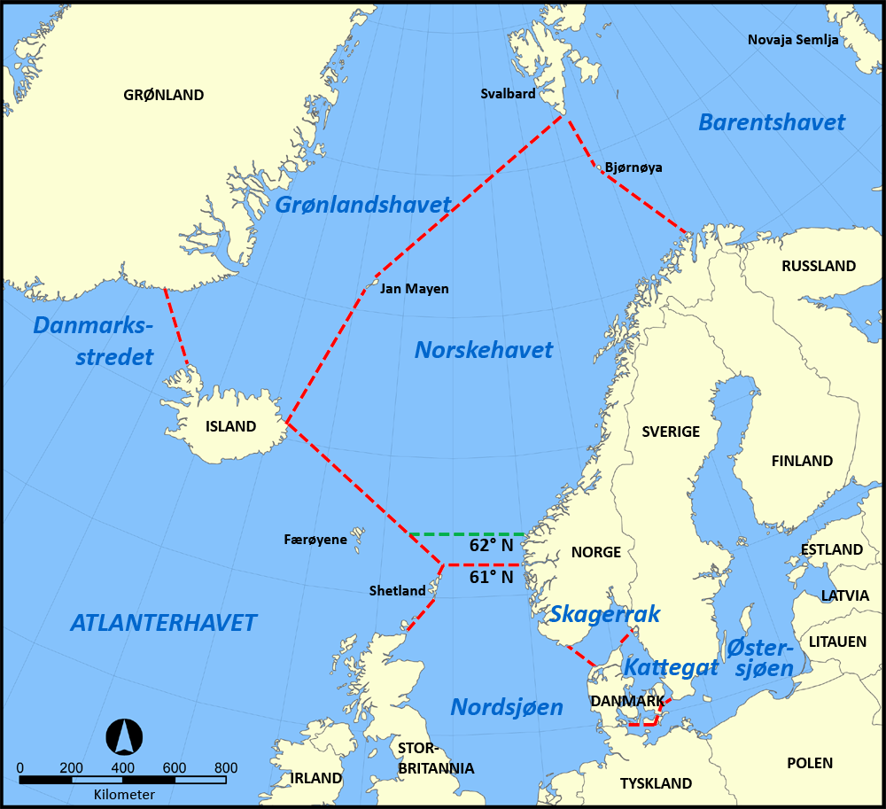
English: A map in Nowegian showing the location of the Norwegian Sea in the North Atlantic Ocean. Svenska: En karta över Norska havets läge i norra Atlanten. Norsk bokmål: Norsk kart over Norskehavets plassering i Nord-Atlanterhavet. |
| Dagur | |
| Kelda | Egið verk |
| Høvundur | Gryphonis |
| Other versions |
[rætta]
|


I, the copyright holder of this work, hereby publish it under the following licenses:
| Henda fíla er gjørd atkomulig undir Creative Commons Navngev-Deil á sama hátt 3.0 Unported loyvinum. | ||
| ||
| This licensing tag was added to this file as part of the GFDL licensing update.http://creativecommons.org/licenses/by-sa/3.0/CC BY-SA 3.0Creative Commons Attribution-Share Alike 3.0truetrue |

|
Loyvi verður givi at avrita, bera út og/ella broyta hetta skjal undir treytunum hjá GNU Free Documentation License, versión 1.2 ella einhvør seinni versjón ið er útgivin av Free Software Foundation; uttan nakað óbroytiligt brot, uttan forsíðutekst og uttan baksíðutekst. Eitt avrit av loyvinum er tikið við í brotinum ið nevnist GNU Free Documentation License.http://www.gnu.org/copyleft/fdl.htmlGFDLGNU Free Documentation Licensetruetrue |
| Henda fíla er gjørd atkomulig undir Creative Commons Navngev-Deil á sama hátt 3.0 Unported loyvinum. | ||
| ||
| This licensing tag was added to this file as part of the GFDL licensing update.http://creativecommons.org/licenses/by-sa/3.0/CC BY-SA 3.0Creative Commons Attribution-Share Alike 3.0truetrue |
Tú kanst velja tann lisens ið tú ynskir.
Original upload log
This image is a derivative work of the following images:
- File:Norwegian_Sea_map.png licensed with Cc-by-sa-3.0-migrated, GFDL
- 2005-11-07T16:10:45Z NormanEinstein 1000x913 (525159 Bytes)
Captions
Add a one-line explanation of what this file represents
Items portrayed in this file
depicts enskt
some value
copyright status enskt
copyrighted enskt
source of file enskt
2. okt 2012
Søgan hjá fíluni
Trýst á dato/tíð fyri at síggja fíluna, sum hon sá út tá.
| Dagur/Tíð | Lítil mynd | Dimensjónir | Brúkari | Viðmerking | |
|---|---|---|---|---|---|
| streymur | 2. okt 2012 kl. 12:19 | | 1.000 × 913 (406 KB) | Gryphonis | update of limits |
| 15. sep 2012 kl. 01:22 |  | 1.000 × 913 (398 KB) | Gryphonis | {{Information |Description ={{en|1={{Information |Description={{en|A map in Nowegian showing the location of the Norwegian Sea in the North Atlantic Ocean.}} {{sv|En svensk karta över Norska havets läge i norra Atlanten.}} {{no|Norsk kart over Nor... |
Myndarslóðir
Hesar síður slóða til hesa mynd:
Alheims fílunýtsla
Aðrar wkiir brúka hesa fílu:
- Nýtsla á de.wikipedia.org
- Nýtsla á nn.wikipedia.org
- Nýtsla á no.wikipedia.org
- Nýtsla á uk.wikipedia.org
Metadáta
Henda fíla inniheldur meiri kunning, sum oftast frá talgilta myndatólinum ella skannaranum, sum tú hevur brúkt til at skapa ella talgilda myndina.
Um fílan er blivin broytt síðan upprunastøðuna, so kunnu nakrir upplýsingar hvørva.
| Vatnrøtt upploysn | 35,43 dpc |
|---|---|
| Loddrøtt upploysn | 35,43 dpc |