File:East-Hem_323bc.jpg
From Wikipedia, the free encyclopedia
پروندهٔ اصلی (۳٬۲۴۰ × ۱٬۹۰۳ پیکسل، اندازهٔ پرونده: ۷۱۲ کیلوبایت، نوع MIME پرونده: image/jpeg)
این پرونده در ویکیانبار موجود است. محتویات صفحهٔ توصیف آن در زیر نمایش داده میشود. |

|
این historical map نگاره میبایست با استفاده از گرافیک برداری اسویجی فایل بازسازی شوند. این چند مزیت دارد؛ Commons:Media for cleanup را برای اطلاعات بیشتر ببینید. اگر حالت برداری آن در حال حاضر موجود است، لطفاً آن را بار کنید. پس از بارکردن یک اسویجی، این الگو را با {{vector version available|new image name.svg}} جایگزین کنید.
|
 | این تصویر (یا تمام تصاویر این مقاله یا رده) بااینکه شامل دادههای غیرعکسبرداریشده هستند، در قالب (فرمت) جیپیئیجی/JPEG بارگذاری شدهاند، اما، آن(ها) شامل اطلاعاتی میباشد که میتوانست با کارایی مناسبتری و دقیقتر در قالب پیانجی/PNG یااسویجی/SVG ذخیره شود. درصورت امکان، لطفاً نسخه PNG یا SVG این تصویر را بدون آسیبهای حاصل از فشرده سازی با استفاده از منبعی غیر-JPEG (یا با حذف آسیبها از تصویر کنونی) بارگذاری کنید، سپس، لطفاً نسخهٔ جیپیئیجی را با {{Superseded|NewImage.ext}} برچسپ بزنید و این پرچسپ را حذف کنید، برای کسب اطلاعات بیشتر {{BadJPEG}} را ببینید. |  |
| توضیحEast-Hem 323bc.jpg |
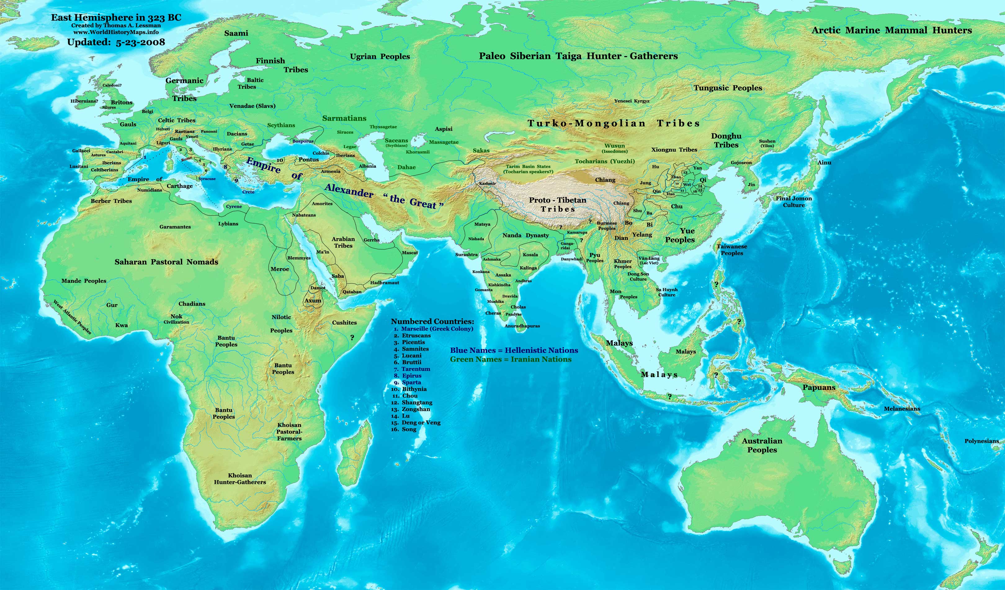
English: Eastern Hemisphere in 323 BC, at the death of Alexander the Great. |
| منبع | اثر شخصی (For reference information, see below) |
| پدیدآور | Thomas Lessman (Contact!) |
| اجازهنامه (استفادهٔ مجدد از این پرونده) |
من، صاحب حقوق قانونی این اثر، به این وسیله این اثر را تحث اجازهنامهٔ ذیل منتشر میکنم: این پرونده با اجازهنامهٔ کریتیو کامانز Attribution-Share Alike 3.0 سازگار نشده منتشر شده است.
|
Map Summary
Original Source URL: http://www.thomaslessman.com/History/images/East-Hem_323bc.jpg.
This map of the Eastern Hemisphere in 323 BC was created by Thomas Lessman, based on information from the sources listed below. This map is free for educational use (see Permission info above). When using this map, please mention that it is available for free at www.WorldHistoryMaps.info.
Map Source References
- Remember, sources often conflict with each other. This map is only as accurate as the information that is available to me.
- To report any errors or to help further this work, please use the Corrections page, or email Thomas Lessman at talessman@yis.us
References for information contained in this map:
Empire of Alexander the Great information is derived from:
- The DK Atlas of World History, 2000 Edition; map of Alexander's Empire and successors; (Pg. 224)
- Wikimedia's map of The Empire of Alexander the Great uploaded by User talk:Captain Blood
- Wikipedia's article about Alexander the Great
I - European Information:
- Roman Republic borders are derived from The DK Atlas of World History, 2000 Edition; Pg. 178; Map of Italy in 240 BCE (also shows Roman borders in 300 BCE).
II - Asian Information:
- Chinese Area borders are derived from this map of The Contending States Boundries c. 350 BC, available on Huhai.net.
- Indian Kingdoms locations are derived from Wikimedia's map of Epic India.
- Gangaridai Note: the borders depicted for Gangaridai are not shown on any maps I've seen, they are described rather vaguely in the sources below:
- This article about The Origins of the Ganga Dynasty - A New Insight archive copy at the Wayback Machine by Dr. Harihar Kanungo; (Pg 25, section a).
- This article from Missouri Southern State University about Gangaridae in Megasthenes' Indica archive copy at the Wayback Machine; (Section 37).
- The History of Bengal website, which contains extensive information on an archeological site called Chandraketugarh, which may be the lost city of Ganga (the capital of Gangaridai).
- Nanda Dynasty borders are derived from:
- The DK Atlas of World History, 2000 Edition; Map of The Nanda and Mauryan Empires 365-181 BCE; (Pg. 241)
- Văn Lang borders are derived from:
- Wikimedia's map of Van Lang, created by User:Briangotts.
- Wikipedia's articles about Văn Lang and the Hồng Bàng Dynasty.
III - African Information and info for fringe areas like Africa, Australia, Siberia, etc. derive from:
- The DK Atlas of World History, 2000 Edition; map of The development of complex societies in Africa; (Page 160)
- Wikimedia's map of the World 323 BCE, created by User:Briangotts, and
- Wikimedia's map of the World in 300 BCE, created by User:Javierfv1212.
Note: Much of the information in this map was cross-checked with Bruce Gordon's Regnal Chronologies.
Other Maps by Thomas Lessman
| Maps of the eastern hemisphere showing history
Bold dates are available on Wikimedia or Wikipedia. | ||
| Primeval | ||
| Ancient
|
·| 600 BC | 550 BC | 527 BC | 500 BC |
400 BC | ·| 1 AD | 50 AD | 100 AD | 200 AD | 300 AD | | |
| Medieval |
·| 500 AD | 565 AD | 600 AD | 700 AD | | |
| Modern |
·| 1500 AD | · * For historical maps of the whole world, | |
| history links talk edit view | ||
سیاهه بارگذاری اصلی
- 2007-12-21 15:09 Talessman 3240×1903×8 (717376 bytes) Corrected info for Far eastern peoples, more info for Africa and Europe
- 2007-11-21 19:34 Talessman 3240×1903×8 (697847 bytes) Added info on lesser-known cultures. Also changed text color of Helenistic states to Blue, of Iranian peoples to green, and added names of smaller nations (numbered legend).
- 2007-11-06 22:20 Talessman 3240×1903×8 (689151 bytes) Corrected borders in Sudan (Meroe) and Arabia, added info for Japan, Indonesia, etc.
- 2007-10-02 17:49 Talessman 2880×1692×8 (546378 bytes) Author: Thomas A. Lessman. Source URL: http://www.ThomasLessman.com/History/images/East-Hem_323bc.jpg. Image was created by me (Thomas Lessman) based on historical information located on Wikipedia, as well as information from maps located in Wikipedia and
- 2007-09-12 21:35 Talessman 2880×1692×8 (514268 bytes) Author: Thomas A. Lessman. Source URL: http://www.ThomasLessman.com/History/images/East-Hem_323bc.jpg. Image was created by me (Thomas Lessman) based on historical information located on Wikipedia, as well as information from maps located in Wikipedia and
عنوان
آیتمهایی که در این پرونده نمایش داده شدهاند
توصیفها
این خصوصیت مقداری دارد اما نامشخص است.
source of file انگلیسی
original creation by uploader انگلیسی
image/jpeg
تاریخچهٔ پرونده
روی تاریخ/زمانها کلیک کنید تا نسخهٔ مربوط به آن هنگام را ببینید.
| تاریخ/زمان | بندانگشتی | ابعاد | کاربر | توضیح | |
|---|---|---|---|---|---|
| کنونی | ۲۶ فوریهٔ ۲۰۱۱، ساعت ۱۵:۰۸ | | ۳٬۲۴۰ در ۱٬۹۰۳ (۷۱۲ کیلوبایت) | Martin H. | Reverted to version as of 07:37, 23 May 2008, downscaling |
| ۲۴ فوریهٔ ۲۰۱۱، ساعت ۱۱:۵۹ |  | ۸۰۰ در ۴۷۰ (۸۶ کیلوبایت) | Prince of Nothing05 | Armenia wasn't part of Alexander the Greta's Empire | |
| ۲۳ مهٔ ۲۰۰۸، ساعت ۰۷:۳۷ |  | ۳٬۲۴۰ در ۱٬۹۰۳ (۷۱۲ کیلوبایت) | Talessman | Corrected borders of Rome, Carthage, Alexander's Empire, Nanda Empire, and China. Also corrected placement of Tocharians, added more info for Europe, India, Africa, and East Asia. | |
| ۹ مهٔ ۲۰۰۸، ساعت ۱۴:۵۳ |  | ۳٬۲۴۰ در ۱٬۹۰۳ (۷۰۸ کیلوبایت) | Talessman | {{Information |Description='''Eastern Hemisphere in 500 BC'''. |Source=self-made (For reference information, see below) |Author=Thomas Lessman (Contact!) |Permission={{self|cc-by-sa-3.0}} }} |
کاربرد پرونده
صفحهٔ زیر از این تصویر استفاده میکند:
کاربرد سراسری پرونده
ویکیهای دیگر زیر از این پرونده استفاده میکنند:
- کاربرد در ar.wikipedia.org
- کاربرد در azb.wikipedia.org
- کاربرد در de.wikipedia.org
- کاربرد در el.wikipedia.org
- کاربرد در en.wikipedia.org
- کاربرد در en.wikibooks.org
- کاربرد در es.wikipedia.org
- کاربرد در it.wikipedia.org
- کاربرد در lv.wikipedia.org
- کاربرد در mk.wikipedia.org
- کاربرد در ru.wikipedia.org
- کاربرد در sh.wikipedia.org
- کاربرد در sl.wikipedia.org
- کاربرد در sq.wikipedia.org
- کاربرد در su.wikipedia.org
- کاربرد در ta.wikipedia.org
- کاربرد در vi.wikipedia.org
- کاربرد در zh.wikibooks.org