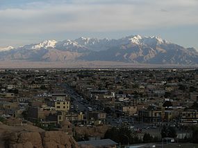
Kerman (hiria)
From Wikipedia, the free encyclopedia
From Wikipedia, the free encyclopedia
Kerman (persieraz: كرمان), Irango erdi-ekialdeko hiria da, Kerman probintziako hiriburua. 2011n 534.441 biztanle zituen[1].
| Kerman | |
|---|---|
| Irango udalerria | |
 | |
| Administrazioa | |
| Estatua | |
| Probintzia | Kerman |
| Postakodea | 761 |
| Geografia | |
| Koordenatuak | 30°17′28″N 57°04′04″E |
| Garaiera | 1.760 metro |
| Eremua | 180,7 kilometro koadro |
| Demografia | |
| Biztanleria | 537.718 biztanle |
| Bestelako informazioa | |
| Telefono aurrizkia | 34 |
| Ordu-eremua | UTC+03:30 |
| Webgune ofiziala | |
Kerman hiria Lut basamortuaren bazter garai batean dago, 1.755 metroko altueran, Teherandik 1.076 kilometro hego-ekialdera.
| | |||||||||||||
|---|---|---|---|---|---|---|---|---|---|---|---|---|---|
| Hila | Urt | Ots | Mar | Api | Mai | Eka | Uzt | Abu | Ira | Urr | Aza | Abe | Urtekoa |
| Batez besteko tenperatura maximoa (°C) | 12.1 | 14.8 | 18.7 | 24.3 | 29.9 | 34.9 | 35.7 | 34.3 | 31.5 | 26.0 | 19.6 | 14.5 | 24.7 |
| Batez besteko tenperatura minimoa (°C) | −3.0 | −0.5 | 3.8 | 8.2 | 12.2 | 16.1 | 17.7 | 14.8 | 10.6 | 5.5 | 0.3 | −2.6 | 7 |
| Pilatutako prezipitazioa (mm) | 29.9 | 26.0 | 34.0 | 18.9 | 11.5 | 1.2 | 1.5 | 0.5 | 0.4 | 1.6 | 5.9 | 21.5 | 152.9 |
| Euri egunak (≥ 1 mm) | 6.9 | 5.9 | 7.9 | 5.8 | 3.8 | 0.7 | 0.9 | 0.5 | 0.5 | 0.9 | 2.4 | 41.4 | |
| Hezetasuna (%) | 52 | 47 | 41 | 34 | 26 | 18 | 18 | 19 | 21 | 27 | 36 | 45 | 31.9 |
| Iturria (1): Kermango klima, weather.ir | |||||||||||||
| Iturria (2): Das Klima in Kerman, wetterkontor.de | |||||||||||||
Seamless Wikipedia browsing. On steroids.
Every time you click a link to Wikipedia, Wiktionary or Wikiquote in your browser's search results, it will show the modern Wikiwand interface.
Wikiwand extension is a five stars, simple, with minimum permission required to keep your browsing private, safe and transparent.