File:East-Hem_565ad.jpg
From Wikipedia, the free encyclopedia
- Fitxategia
- Fitxategiaren historia
- Irudira dakarten loturak
- Fitxategiaren erabilera orokorra
- Metadatuak
Bereizmen handikoa ((3.240 × 1.903 pixel, fitxategiaren tamaina: 773 KB, MIME mota: image/jpeg))
Fitxategi hau Wikimedia Commonsekoa da. Hango deskribapen orriko informazioa behean duzu. |

|
Irudi hau birsortu beharko litzateke SVG irudi bektorial moduan. Honek abantaila asko ematen ditu, ikus Commons:Media for cleanup (ingelesez) informazio gehiagorako. Irudi honen SVG bertsioa eskuragarri badago, mesedez Commonsera igo. Igo ostean, ordezkatu txantiloi hau txantiloi honegatik {{vector version available|irudiaren izen berria.svg}} irudi honetan.
|
 | This historical map image was uploaded in the JPEG format even though it consists of non-photographic data. This information could be stored more efficiently or accurately in the PNG or SVG format. If possible, please upload a PNG or SVG version of this image without compression artifacts, derived from a non-JPEG source (or with existing artifacts removed). After doing so, please tag the JPEG version with {{Superseded|NewImage.ext}} and remove this tag. This tag should not be applied to photographs or scans. If this image is a diagram or other image suitable for vectorisation, please tag this image with {{Convert to SVG}} instead of {{BadJPEG}}. If not suitable for vectorisation, use {{Convert to PNG}}. For more information, see {{BadJPEG}}. |  |
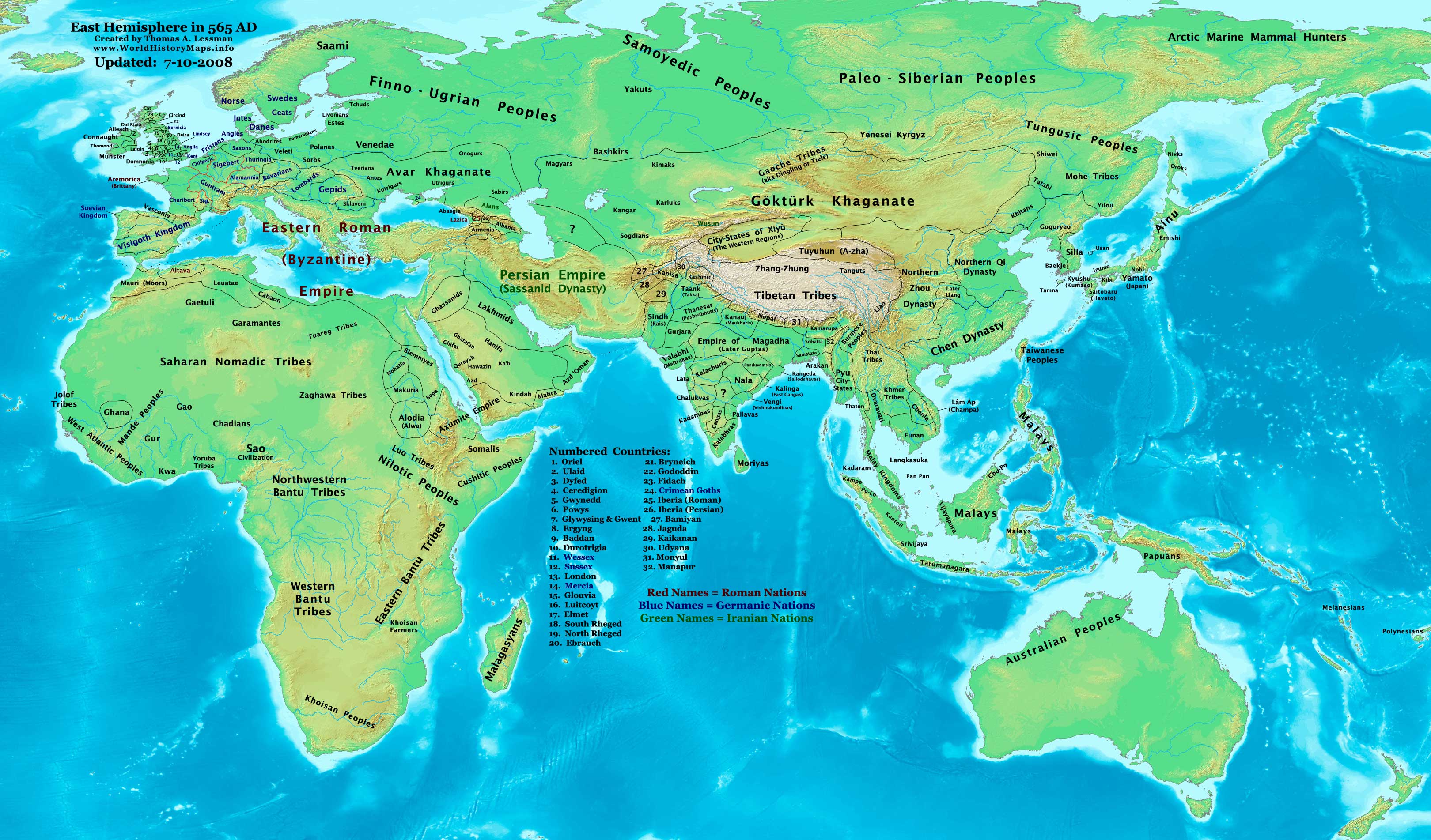
| DeskribapenaEast-Hem 565ad.jpg |
English: Eastern Hemisphere in 565 AD |
| Jatorria | self-made (For reference information, see the Map Source References section below.) |
| Egilea | Thomas Lessman (Contact!) |
| Lizentzia (Fitxategi hau berrerabiltzen) |
Nik, lan honen egileak, argitaratzen dut ondorengo lizentzia pean: Fitxategi hau Creative Commons Attribution-Share Alike 3.0 Unported lizentziapean dago.
|
| Beste bertsioak |
Derivative works of this file: see East-Hem_565ad.jpg file history on Wikipedia. |
Map Summary
Original Source URL: http://www.thomaslessman.com/History/images/East-Hem_565ad.jpg.
This map of the Eastern Hemisphere in 565 AD was created by Thomas Lessman, based on information from the sources listed below. This map is free for educational use (see Permission info above). When using this map, please mention that it is available for free at www.WorldHistoryMaps.info.
Map Source References
- Remember, sources often conflict with each other. This map is only as accurate as the information that is available to me. To report any errors or to help further this work, please click here, or email Thomas Lessman at talessman@yis.us
References for information contained in this map:
Primary Sources for East-Hem_565ad.jpg:
- 1. The DK Atlas of World History, 2000 Edition; map of The World in 500 CE, (Pages 50-51) (See other specific references below)
- 2. John Nelson. Map of the "Countries of the World 1/1/565 CE." Interactive Historical Atlas of the World since 500BCE. World History Maps Inc., Alexandria, VA, 2008. Available at www.WorldHistoryMaps.com.
- 3. The History & Commercial Atlas of China, maps of The Divisions of China, 530 & 560 AD and Asia in 610 AD, available at Huhai.net
- 4. Wikimedia's World Map 500 CE, made by User:Javierfv1212, and Wikipedia articles (noted below).
I - African Information
Note: Most of my African Information comes from The DK Atlas of World History map of The Development of Complex Societies in Africa; (Pg 160).
- (Bantus, Berber Tribes, Chadians, Cushites, Daamat, Garamantes, Gur, Khoisan Peoples, Kwa, Libyans, Mandes, Nilotic Peoples, West Atlantic Peoples)
- Nubian/Sudanese borders (Makuria, Nobatia, Alodia, Blemmyes, Bega, Axum, etc.) are derived from these sources:
- 1. The DK Atlas of World History map of "Northeast Africa, c. 500 CE"; (Pg. 161)
- 2. Denis Bellemare. Historical Atlas of Late Antiquity. Map of Arabia in 540 AD
- Ghana's location is derived from John Nelson's map of the "Countries of the World, 1-1-500 CE", available at www.WorldHistoryMaps.com.
- North African borders are derived from a comparison of
- 1. Denis Bellemare. Historical Atlas of Late Antiquity. Comparison of the maps of North Africa in 540 AD and North Africa in 580 AD.
II - Asian Information
- Arabian borders & Tribal locations are derived from a combination of these sources:
- 1. The MidEastWeb.org map of Arabia in 500 CE.
- 2. Denis Bellemare. Historical Atlas of Late Antiquity. Maps of "Southern Arabia in 540 AD and North Arabia in 540 AD.
- 3. Wikipedia's map of Pre-Islamic Arab tribal locations, created by User:Slackerlawstudent.
Note: I used information in various Wikipedia articles to reconcile the maps and the borders I depict for Arabia.
- Chinese Borders are derived from the History & Commercial Atlas of China, map of The Divisions of China, 530 & 560 AD, available on Huhai.net
- India's borders are derived from these sources:
- 1. John Nelson. Map of the "Countries of the World 1/1/565 CE." Interactive Historical Atlas of the World since 500BCE. World History Maps Inc., Alexandria, VA, 2008. Available at www.WorldHistoryMaps.com.
- 2. The Historical Atlas of South Asia, maps of "The Gupta-Vakataka Age, c. A.D. 300-500" and "The age of Pusyabhuti and Calukyan ascendancy, c. A.D. 550-700", by Joseph Schwartzberg.
- Japanese information is derived from The DK Atlas of World History map of "State Formation in Korea & Japan to 650 CE"; (Pg 264)
III - European Information
Note: Borders of Europe are mostly derived from a combination of:
1. The www.Euratlas.com map of Europe in 600 AD and to a lesser extent, their map of Europe in 500 AD.
- (Please note: User:Bogomolov.PL has done a great job of showing me possible discrepancies in my north European borders compared to this source, due to the differences in the geographical layout of the maps.)
2. John Nelson. Map of the "Countries of the World 1/1/565 CE." Interactive Historical Atlas of the World since 500BCE. World History Maps Inc., Alexandria, VA, 2008. Available at www.WorldHistoryMaps.com.
- British/English Borders derived from "Early British Kingdoms" map of Britain in 550 AD and their map of Britain in 575 AD.
4. Fringe areas like Africa, Australia, Siberia, etc. are partially derived from Wikimedia's map of The world in 500 CE, created by User:Javierfv1212.
5. Much of the information in this map was cross-checked with Bruce Gordon's Regnal Chronologies.
Other Maps by Thomas Lessman
| Maps of the eastern hemisphere showing history
Bold dates are available on Wikimedia or Wikipedia. | ||
| Primeval | ||
| Ancient
|
·| 600 BC | 550 BC | 527 BC | 500 BC |
400 BC | ·| 1 AD | 50 AD | 100 AD | 200 AD | 300 AD | | |
| Medieval |
·| 500 AD | 565 AD | 600 AD | 700 AD | | |
| Modern |
·| 1500 AD | · * For historical maps of the whole world, | |
| history links talk edit view | ||
Irudi-oineko testuak
Fitxategi honetan agertzen diren itemak
honako hau irudikatzen du
some value
Fitxategiaren historia
Data/orduan klik egin fitxategiak orduan zuen itxura ikusteko.
| Data/Ordua | Iruditxoa | Neurriak | Erabiltzailea | Iruzkina | |
|---|---|---|---|---|---|
| oraingoa | 00:29, 11 uztaila 2008 | | 3.240 × 1.903 (773 KB) | Talessman | |
| 23:18, 9 maiatza 2008 |  | 3.240 × 1.903 (760 KB) | Talessman | {{Information |Description=Eastern Hemisphere in 565 AD. |Source=self-made |Author=Thomas Lessman |Permission={{self|cc-by-sa-3.0}} }} |
Irudira dakarten loturak
Ez dago fitxategi hau darabilen orririk.
Fitxategiaren erabilera orokorra
Hurrengo beste wikiek fitxategi hau darabilte:
- azb.wikipedia.org proiektuan duen erabilera
- bar.wikipedia.org proiektuan duen erabilera
- be.wikipedia.org proiektuan duen erabilera
- br.wikipedia.org proiektuan duen erabilera
- de.wikipedia.org proiektuan duen erabilera
- el.wikipedia.org proiektuan duen erabilera
- en.wikipedia.org proiektuan duen erabilera
- es.wikipedia.org proiektuan duen erabilera
- fa.wikipedia.org proiektuan duen erabilera
- fr.wikipedia.org proiektuan duen erabilera
- hr.wikipedia.org proiektuan duen erabilera
- hy.wikipedia.org proiektuan duen erabilera
- ka.wikipedia.org proiektuan duen erabilera
- mn.wikipedia.org proiektuan duen erabilera
- no.wikipedia.org proiektuan duen erabilera
- pt.wikipedia.org proiektuan duen erabilera
- rue.wikipedia.org proiektuan duen erabilera
- ru.wikipedia.org proiektuan duen erabilera
- sh.wikipedia.org proiektuan duen erabilera
- sl.wikipedia.org proiektuan duen erabilera
- sv.wikipedia.org proiektuan duen erabilera
- tr.wikipedia.org proiektuan duen erabilera
- uk.wikipedia.org proiektuan duen erabilera
- vi.wikipedia.org proiektuan duen erabilera
Metadatuak
Fitxategi honek informazio gehigarri dauka, ziurrenik kamera digital edo eskanerrak egiterako momentuan gehitutakoa. Hori dela-eta, jatorrizko fitxategi hori aldatu egin bada, baliteke xehetasun batzuek errealitatearekin bat ez egitea.
| _error | 0 |
|---|