File:Rzeczpospolita.png
From Wikipedia, the free encyclopedia
Algfail (2000 × 1568 pikslit, faili suurus: 332 KB, MIME tüüp: image/png)
| See fail ja sellest kastist allapoole jääv kirjeldus pärinevad kesksest failivaramust Wikimedia Commons. | Faili lehekülg Commonsis |
Lühikirjeldus
| KirjeldusRzeczpospolita.png |
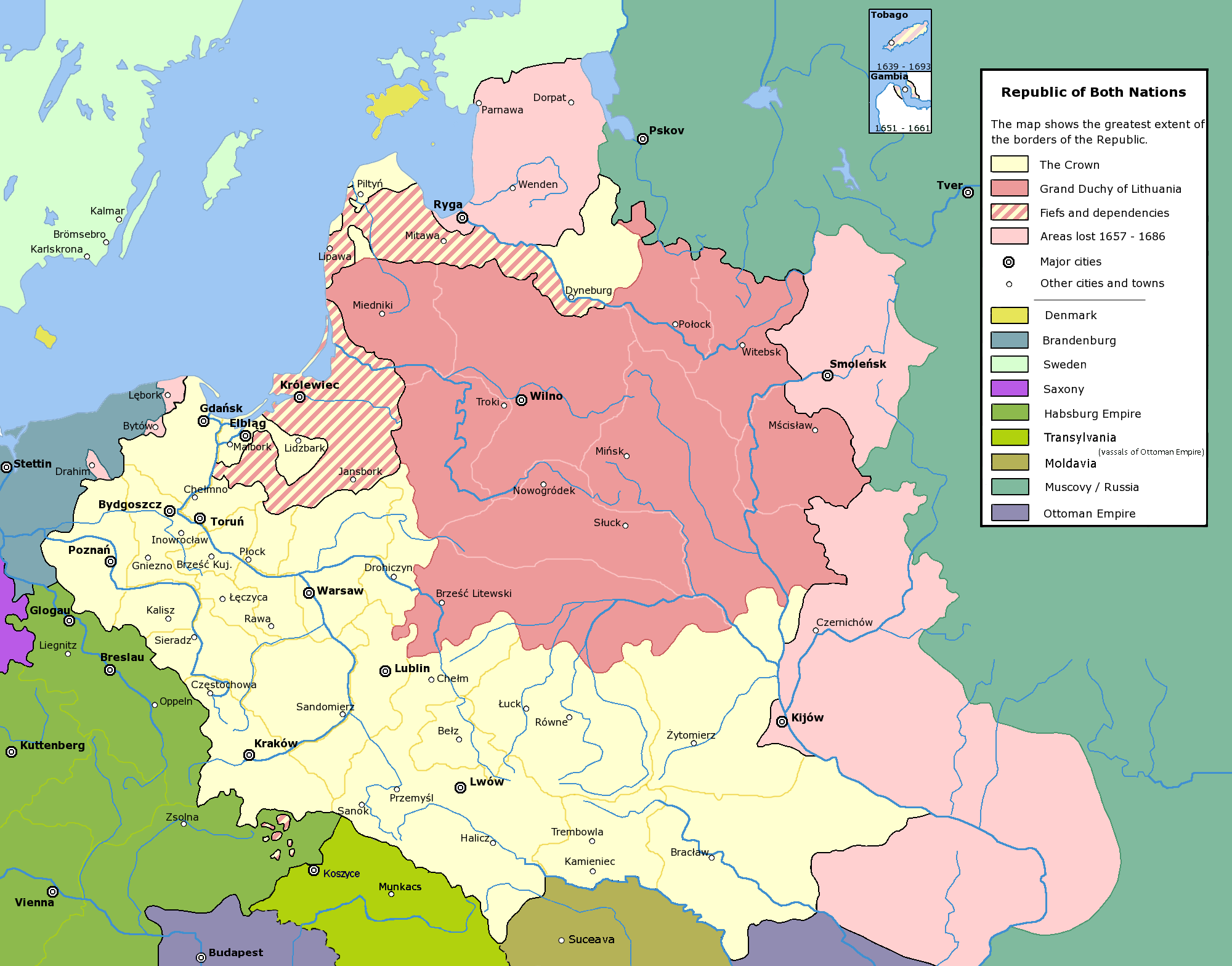
English: Commonwealth of Both Nations at the peak of its strength. The areas marked with light pink were lost to:
|
| Kuupäev | |
| Allikas | Üleslaadija oma töö |
| Autor | Halibutt |
| Luba (Faili edasikasutus) |
GFDL, see below |
| Teised versioonid |
|

|
See pilt tuleks konverteerida kasutades vektorgraafikat (SVG-vorming). Vektorkujutisel on mitmeid eeliseid. Konverteerimise kohta vaata täpsemalt siit. Kui sellest pildist on vektorkujutis juba saadaval, siis pane selle malli asemele {{vector version available|uue pildi nimi.svg}}.
|
Litsents
Since the legal status of the above comment has been questioned, I hereby grant anyone the right to treat it as either a standard copyright notice, invariant section, legal statement, legal advice, friendly suggestion or a mere comment, depending on his or hers own choice. |
|

History of Poland
The following is a list of maps created by Halibutt and uploaded to commons, as well as their present and projected derivatives.
| Parent Image | Image | Description | |||||||||||
|---|---|---|---|---|---|---|---|---|---|---|---|---|---|
| Maps by Halibutt | |||||||||||||
| Image:Rzeczpospolita.png | Image:Rzeczpospolita.png | The Republic in 17th and 18th century | |||||||||||
| Image:Rzeczpospolita 1600.png | The Republic after the Treaty of Dywilino | ||||||||||||
| Image:Rzeczpospolita voivodships.png | Voivodships of The Republic | ||||||||||||
| Image:Rzeczpospolita_Potop.png | The Republic during The Deluge and Chmielnicki Uprising, with major battles of the era marked | ||||||||||||
| Magnates and their lands and domains | |||||||||||||
| 1st • 2nd • 3rd | Partitions of Poland | ||||||||||||
| War of the constitution | |||||||||||||
| Image:Rzeczpospolita.xcf | SOURCE FILE - GIMP format | ||||||||||||
| Image:Poland 1939.png | Image:Poland 1939.png | Poland in 1939 | |||||||||||
| Image:Dywizje wrzesien 1.png | Order of Battle on September 1st, during the Polish Defence War of 1939 | ||||||||||||
| Image:Poland 1939.xcf | SOURCE FILE - GIMP format | ||||||||||||
| Image:Polska kontur bialy.png | Image:Polska kontur bialy.png | Contour map of Poland AD 1999, for use with various locator maps | |||||||||||
| Image:Rzeczpospolita 1923.png | Image:Rzeczpospolita 1923.png | Map of Poland 1918-1939, currently under development | |||||||||||
| Image:PBW March 1919.png | Polish-Bolshevik War - fronts in March of 1919 | ||||||||||||
| Image:PBW December 1919.png | Polish-Bolshevik War - fronts in December of 1919 | ||||||||||||
| Image:PBW June 1920.png | Polish-Bolshevik War - fronts in July of 1920 | ||||||||||||
| Image:PBW August 1920.png | Polish-Bolshevik War - fronts in August of 1920 | ||||||||||||
| Polish Defence War of 1939 | |||||||||||||
| Polish areas annexed by Germany, Lithuania, Slovakia and the Soviet Union | |||||||||||||
| German concentration camps in Poland | |||||||||||||
| Curzon line | |||||||||||||
| Major battles of the Polish-Bolshevik War | |||||||||||||
| names • no names | Polish/Czechoslovak/Lithuanian/German/Ukrainian claims in 1920's | ||||||||||||
| Image:Rzeczpospolita Central Lithuania.png | Central Lithuania | ||||||||||||
| Image:Rzeczpospolita Lithuania claims.png | Central Lithuania as compared with other Lithuanian claims | ||||||||||||
| Image:Rzeczpospolita 1789-1920.png | Post-1922 borders compared with the territory of Poland before the partitions | ||||||||||||
| Warsaw Uprising and the Operation Tempest | |||||||||||||
| Poland partitioned between the Soviets and the Germans | |||||||||||||
| Image:Rzeczpospolita 1939 Polish divisions.png | Polish divisions on September 1, 1939 | ||||||||||||
| Home Army inspectorates | |||||||||||||
| Image:Rzeczpospolita 1922.xcf | SOURCE FILE - GIMP format | ||||||||||||
| Image:Rzeczpospolita 1937.svg | Vector version!!!! | layered version available on request | |||||||||||

|
This image (or all images in this category) uses inside labels or attached captions in a specific script or language and should be converted to a language neutral form. This would allow its use in all Wikimedia projects and, more importantly, all Wikimedia languages.
Bahasa Melayu ∙ català ∙ čeština ∙ Deutsch ∙ English ∙ español ∙ français ∙ italiano ∙ magyar ∙ Nederlands ∙ Plattdüütsch ∙ português ∙ sicilianu ∙ slovenčina ∙ suomi ∙ беларуская (тарашкевіца) ∙ македонски ∙ русский ∙ српски / srpski ∙ 한국어 ∙ 日本語 ∙ 中文 ∙ 中文(简体) ∙ فارسی ∙ +/− |
Pealdised
Selles failis kujutatud üksused
kujutab
Teatud väärtus ilma Vikiandmete üksuseta
8. detsember 2004
Faili ajalugu
Klõpsa kuupäeva ja kellaaega, et näha sel ajahetkel kasutusel olnud failiversiooni.
| Kuupäev/kellaaeg | Pisipilt | Mõõtmed | Kasutaja | Kommentaar | |
|---|---|---|---|---|---|
| viimane | 6. mai 2016, kell 17:37 | | 2000 × 1568 (332 KB) | Julieta39 | Cosmetic changes: see sources in the discussion page of today. |
| 8. detsember 2009, kell 13:40 |  | 2000 × 1568 (221 KB) | Tryphon | Removed watermark. | |
| 13. detsember 2004, kell 22:34 |  | 2000 × 1568 (304 KB) | Halibutt | Ok, final version at last (unless you have some more comments or suggestions) | |
| 10. detsember 2004, kell 10:47 |  | 2000 × 1568 (297 KB) | Halibutt | final version? | |
| 10. detsember 2004, kell 04:36 |  | 2000 × 1568 (193 KB) | Halibutt | new update | |
| 8. detsember 2004, kell 06:23 |  | 2000 × 1568 (141 KB) | Halibutt | Commonwealth of Both Nations at the peak of its strength<br>Beta version of a map by Halibutt<br>{{User:Halibutt/GFDL}} |
Faili kasutus
Seda faili kasutavad järgmised 2 lehekülge:
Globaalne failikasutus
Järgmised muud vikid kasutavad seda faili:
- Faili kasutus vikis ar.wikipedia.org
- Faili kasutus vikis arz.wikipedia.org
- Faili kasutus vikis azb.wikipedia.org
- Faili kasutus vikis bg.wikipedia.org
- Faili kasutus vikis br.wikipedia.org
- Faili kasutus vikis ca.wikipedia.org
- Faili kasutus vikis da.wikipedia.org
- Faili kasutus vikis de.wikipedia.org
- Faili kasutus vikis de.wikibooks.org
- Faili kasutus vikis en.wikipedia.org
- John III Sobieski
- User:Halibutt
- Stanisław Koniecpolski
- Wikipedia:Today's featured article/January 2005
- Wikipedia:Today's featured article/January 11, 2005
- Talk:Eastern and Western Vilnius regions
- Talk:Russian Mennonites
- User:Art Serebren
- User talk:Mikołajski
- User:Cyborg Ninja/sandbox
- User:Falcaorib/Poland-Lithuania
- Faili kasutus vikis eo.wikipedia.org
- Faili kasutus vikis fi.wikipedia.org
- Faili kasutus vikis fr.wikipedia.org
- Faili kasutus vikis gl.wikipedia.org
- Faili kasutus vikis hr.wikipedia.org
- Faili kasutus vikis hsb.wikipedia.org
- Faili kasutus vikis hu.wikipedia.org
- Faili kasutus vikis id.wikipedia.org
- Faili kasutus vikis it.wikipedia.org
- Faili kasutus vikis ja.wikipedia.org
Vaata selle faili globaalset kasutust.
Metaandmed
See fail sisaldab lisateavet, mille on tõenäoliselt lisanud digikaamera või skanner.
Kui faili on rakendustarkvaraga töödeldud, võib osa andmeid olla muudetud või täielikult eemaldatud.
| Horisontaalne eraldus | 28,35 dpc |
|---|---|
| Vertikaalne eraldus | 28,35 dpc |