Yutian County, Xinjiang
County in Xinjiang, China From Wikipedia, the free encyclopedia

Yutian County (Chinese: 于田县), also transliterated from Uyghur as Keriya County (Uyghur: كېرىيە ناھىيىسى; Chinese: 克里雅县), is a county in Hotan Prefecture, Xinjiang Uyghur Autonomous Region, China. It is based at the Keriya Town, and is separate from Hotan County, which is another county in the same prefecture. The Yutian County has an area of 39,023 km2 (15,067 sq mi). According to the 2002 census, it has a population of 220,000. The county is bounded on the north by Aksu Prefecture, on the east by Minfeng/Niya County, on the west by Qira County and on the south by the Rutog and Gertse counties of the Tibet Autonomous Region.
Yutian County
Keriya County | |
|---|---|
.jpg) Kereya International On Foot Street | |
.png) Location of the county (red) within Hotan Prefecture (yellow) and Xinjiang | |
 Yutian Location of the seat in Xinjiang  Yutian Yutian (Xinjiang)  Yutian Yutian (China) | |
| Coordinates: 36°52′N 81°42′E | |
| Country | China |
| Autonomous region | Xinjiang |
| Prefecture | Hotan |
| County seat | Mughalla (Keriya) |
| Area | |
• Total | 39,094.83 km2 (15,094.60 sq mi) |
| Population (2020)[2] | |
• Total | 257,038 |
| • Density | 6.6/km2 (17/sq mi) |
| Ethnic groups | |
| • Major ethnic groups | Uyghur[3][4] |
| Time zone | UTC+8 (China Standard[a]) |
| Postal code | 848400 |
| Website | www |
| Yutian County, Xinjiang | |||||||||||
|---|---|---|---|---|---|---|---|---|---|---|---|
| Chinese name | |||||||||||
| Simplified Chinese | 于田县 | ||||||||||
| Traditional Chinese | 于田縣 | ||||||||||
| |||||||||||
| Alternative Chinese name | |||||||||||
| Simplified Chinese | 玉田县 | ||||||||||
| Traditional Chinese | 玉田縣 | ||||||||||
| |||||||||||
| Second alternative Chinese name | |||||||||||
| Simplified Chinese | 克里雅县 | ||||||||||
| Traditional Chinese | 克里雅縣 | ||||||||||
| |||||||||||
| Uyghur name | |||||||||||
| Uyghur | كېرىيە ناھىيىسى | ||||||||||
| |||||||||||
Name
The county derives its Chinese name from the Kingdom of Khotan. The name was written as '于闐' at that time.[5] This was later changed to '玉田' (literally, Jade Field) following the adoption of Simplified Chinese and eventually to '于田' in 1959.[6][7] The three names have a similar pronunciation in Mandarin Chinese.
"Keriya", the Latin transliteration of the Uyghur name for the county, is derived from the name of the Keriya River.
Yutian County is dubbed the "Home of Jade".[8]
History
Summarize
Perspective
The ancient name of Keriya was Yumi (扜彌, Gyuymi, Umi). The name Yumi was used by the Chinese envoy Zhang Qian in his 125 BCE report on his embassy's travels.
Yutian County (于阗县) was formed in 1882, its administrative center was Karakash, and Keriya was only a post station. In 1885, the administrative center of the county was moved to Keriya.
Aurel Stein travelled along the Keriya River in his early 20th century expeditions in the region.[9]
In 1920, the area was part of Hotan Dao (和闐道).[10]
In 1950, the area was part of Hotan Special Area (和闐專區).[10]
In 1959, the Chinese character name for the county was set as '于田'.[6][10]
In 1977, the area became part of Hotan Prefecture.[10]
In November 1980, the Yutian hydroelectric plant, located on the Keriya River, went into operation.[11]
On March 21, 2008, the county was at the epicenter of a 7.1/7.3 magnitude earthquake.[12][13]
In February 2014, the county was at the epicenter of the 6.8 magnitude 2014 Yutian earthquake. No injuries or deaths were reported.[14]
In 2018, the Financial Times reported that the Yutian county vocational training centre, among the largest of the Xinjiang internment camps, had opened a forced labour facility including eight factories spanning shoemaking, mobile phone assembly and tea packaging, giving a base monthly salary of ¥1,500 ($220). Between 2016 and 2018, the centre expanded 269 percent in total area.[15]
In 2018, Regiment 225 (兵团二二五团, part of Kunyu,[16] was listed as part of the county.[17]
Administrative divisions
Summarize
Perspective
Yutian county includes two towns and thirteen townships:[1][17][18]
| Name | Simplified Chinese | Hanyu Pinyin | Uyghur (UEY) | Uyghur Latin (ULY) | Administrative division code | |
|---|---|---|---|---|---|---|
| Towns | ||||||
| Mughalla Town | 木尕拉镇 | Mùgǎlā Zhèn | مۇغاللا بازىرى | mughalla baziri | 653226100 | |
| Xambabazar Town | 先拜巴扎镇 | Xiānbàibāzhā Zhèn | شەنبە بازار بازىرى | shenbebazar baziri | 653226101 | |
| Townships | ||||||
| Jay Township | 加依乡 | Jiāyī Xiāng | جاي يېزىسى | jay yëzisi | 653226200 | |
| Kokyar Township | 科克亚乡 | Kēkèyà Xiāng | كۆكيار يېزىسى[19] | kökyar yëzisi | 653226201 | |
| Aral Township | 阿热勒乡 | Ārèlè Xiāng | ئارال يېزىسى | Aral yëzisi | 653226202 | |
| Arix Township | 阿日希乡 | Ārìxī Xiāng | ئارىش يېزىسى | Arish yëzisi | 653226203 | |
| Lengger Township (Bogazlanggar) |
兰干乡 | Lángàn Xiāng | لەڭگەر يېزىسى | lengger yëzisi | 653226204 | |
| Siyak Township[20] | 斯也克乡 | Sīyěkè Xiāng | سىيەك يېزىسى | siyek yëzisi | 653226205 | |
| Togragaz Township (Tagdaxman) |
托格日尕孜乡 | Tuōgérìgǎzī Xiāng | توغراغاز يېزىسى | toghraghaz yëzisi | 653226206 | |
| Karaki Township | 喀拉克尔乡 | Kālākè'ěr Xiāng | قارقى يېزىسى | qarqi yëzisi | 653226207 | |
| Oytograk Township | 奥依托格拉克乡 | Àoyītuōgélākè Xiāng | ئويتوغراق يېزىسى | Oytoghraq yëzisi | 653226208 | |
| Aqqan Township | 阿羌乡 | Āqiāng Xiāng | ئاچچان يېزىسى | Achchan yëzisi | 653226209 | |
| Yengibag Township | 英巴格乡 | Yīngbāgé Xiāng | يېڭىباغ يېزىسى | yëngibagh yëzisi | 653226210 | |
| Shiwol Township | 希吾勒乡 | Xīwúlè Xiāng | شىۋول يېزىسى | shiwol yëzisi | 653226211 | |
| Darya Boyi Township | 达里雅布依乡 | Dálǐyǎbùyī Xiāng | دەريا بۇيى يېزىسى | deryabuyi yëzisi | 653226212 | |
Climate
| Climate data for Yutian, elevation 1,422 m (4,665 ft), (1991–2020 normals, extremes 1981–2010) | |||||||||||||
|---|---|---|---|---|---|---|---|---|---|---|---|---|---|
| Month | Jan | Feb | Mar | Apr | May | Jun | Jul | Aug | Sep | Oct | Nov | Dec | Year |
| Record high °C (°F) | 18.9 (66.0) |
23.8 (74.8) |
32.3 (90.1) |
36.0 (96.8) |
37.8 (100.0) |
39.2 (102.6) |
40.0 (104.0) |
40.5 (104.9) |
37.3 (99.1) |
31.5 (88.7) |
24.4 (75.9) |
18.7 (65.7) |
40.5 (104.9) |
| Mean daily maximum °C (°F) | 1.7 (35.1) |
7.7 (45.9) |
17.2 (63.0) |
24.5 (76.1) |
28.3 (82.9) |
31.2 (88.2) |
32.7 (90.9) |
31.5 (88.7) |
28.0 (82.4) |
21.6 (70.9) |
12.5 (54.5) |
3.9 (39.0) |
20.1 (68.1) |
| Daily mean °C (°F) | −4.8 (23.4) |
0.9 (33.6) |
9.6 (49.3) |
16.4 (61.5) |
20.2 (68.4) |
23.5 (74.3) |
24.9 (76.8) |
23.7 (74.7) |
19.1 (66.4) |
11.5 (52.7) |
4.0 (39.2) |
−2.8 (27.0) |
12.2 (53.9) |
| Mean daily minimum °C (°F) | −10.2 (13.6) |
−5.1 (22.8) |
2.4 (36.3) |
8.7 (47.7) |
12.8 (55.0) |
16.7 (62.1) |
18.4 (65.1) |
17.1 (62.8) |
11.8 (53.2) |
3.5 (38.3) |
−2.6 (27.3) |
−7.8 (18.0) |
5.5 (41.9) |
| Record low °C (°F) | −21.7 (−7.1) |
−22.8 (−9.0) |
−9.3 (15.3) |
−1.4 (29.5) |
0.7 (33.3) |
6.5 (43.7) |
10.0 (50.0) |
6.9 (44.4) |
1.0 (33.8) |
−4.2 (24.4) |
−11.6 (11.1) |
−22.6 (−8.7) |
−22.8 (−9.0) |
| Average precipitation mm (inches) | 1.8 (0.07) |
1.7 (0.07) |
1.9 (0.07) |
4.2 (0.17) |
5.9 (0.23) |
14.5 (0.57) |
11.8 (0.46) |
7.0 (0.28) |
8.3 (0.33) |
0.8 (0.03) |
0.4 (0.02) |
0.7 (0.03) |
59 (2.33) |
| Average precipitation days (≥ 0.1 mm) | 2.3 | 1.4 | 0.7 | 1.0 | 2.3 | 4.3 | 3.5 | 2.4 | 1.7 | 0.4 | 0.3 | 1.1 | 21.4 |
| Average snowy days | 4.7 | 2.2 | 0.7 | 0.1 | 0 | 0 | 0 | 0 | 0 | 0 | 0.7 | 3.2 | 11.6 |
| Average relative humidity (%) | 55 | 46 | 32 | 31 | 39 | 44 | 50 | 53 | 53 | 49 | 46 | 55 | 46 |
| Mean monthly sunshine hours | 206.0 | 203.8 | 234.8 | 240.9 | 264.7 | 260.0 | 254.8 | 240.6 | 256.0 | 279.9 | 239.2 | 212.8 | 2,893.5 |
| Percent possible sunshine | 66 | 66 | 63 | 60 | 60 | 59 | 58 | 58 | 70 | 82 | 79 | 71 | 66 |
| Source: China Meteorological Administration[21][22] | |||||||||||||
Economy
The county is known for its production of jade. Agriculture and livestock farming in the county produces corn, wheat, rice, cotton, grapes and melons. Industries in the county include jade mining, cotton ginning, tractor repair and preserved fruit processing.[6]
Demographics
As of 2015, 277,206 of the 282,182 residents of the county were Uyghur, 4,678 were Han Chinese and 298 were from other ethnic groups.[23]
In the late 2010s, Uyghurs made up 98.3% of the population of the county.[3]
As of 1999, 98.56% of the population of Keriya (Yutian) County was Uyghur and 1.37% of the population was Han Chinese.[24]
Transportation
- China National Highway 315
- Yutian Wanfang Airport
- Yutian railway station on Hotan–Ruoqiang railway
Notable persons
- Kurban Tulum, promoted by the Chinese Communist Party as a symbol of unity with the Uyghurs
Gallery
 Map including Kiriá (1865)
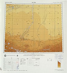 Map including Yutian (labeled as YÜ-TIEN (KERIYA) (YÜ-T'IEN)) and surrounding region in the International Map of the World (USATC, 1971)[b]
 Map including Keriya (labeled as YÜ-TIEN (YUT'IEN) (ATC, 1971)
 Map including the southern part of Yutian/Keriya County and the county's border with Tibet (AMS, 1950)


Notes
- Locals in Xinjiang frequently observe UTC+6 (Xinjiang Time), 2 hours behind Beijing.
References
See also
Wikiwand - on
Seamless Wikipedia browsing. On steroids.