Wusterhausen
Municipality in Brandenburg, Germany From Wikipedia, the free encyclopedia
Wusterhausen (German pronunciation: [vʊstɐˈhaʊ̯zn̩]; official name Wusterhausen/Dosse) is a municipality in the Ostprignitz-Ruppin district, in northwestern Brandenburg, Germany. It is situated on the river Dosse, 7 km southeast of Kyritz, and 75 km northwest of Berlin.
Wusterhausen | |
|---|---|
 Church in Nackel | |
.png) Coat of arms | |
Location of Wusterhausen
within Ostprignitz-Ruppin district  | |
 Wusterhausen  Wusterhausen | |
| Coordinates: 52°52′59″N 12°28′00″E | |
| Country | Germany |
| State | Brandenburg |
| District | Ostprignitz-Ruppin |
| Government | |
| • Mayor (2018–26) | Philipp Schulz[1] (Ind.) |
| Area | |
• Total | 195.42 km2 (75.45 sq mi) |
| Elevation | 33 m (108 ft) |
| Population (2022-12-31)[2] | |
• Total | 5,854 |
| • Density | 30/km2 (78/sq mi) |
| Time zone | UTC+01:00 (CET) |
| • Summer (DST) | UTC+02:00 (CEST) |
| Postal codes | 16868 |
| Dialling codes | 033979 |
| Vehicle registration | OPR |
| Website | www.wusterhausen.de |
History
From 1815 to 1945, Wusterhausen was part of the Prussian Province of Brandenburg. From 1952 to 1990, it was part of the Bezirk Potsdam of East Germany.
Demography
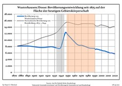 Development of population since 1875 within the current Boundaries (Blue Line: Population; Dotted Line: Comparison to Population development in Brandenburg state; Grey Background: Time of Nazi Germany; Red Background: Time of communist East Germany)
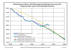 Recent Population Development and Projections (Population Development before Census 2011 (blue line); Recent Population Development according to the Census in Germany in 2011 (blue bordered line); Official projections for 2005-2030 (yellow line); for 2017-2030 (scarlet line); for 2020-2030 (green line)


|
|
|
People
- Dieter Helm (1941–2022), farmer and politician
- Hermann Wagener (1815-1889), journalist and politician
References
Wikiwand - on
Seamless Wikipedia browsing. On steroids.