Wojtal
Village in Pomeranian Voivodeship, Poland From Wikipedia, the free encyclopedia
Village in Pomeranian Voivodeship, Poland From Wikipedia, the free encyclopedia
Wojtal [ˈvɔi̯tal] is a village in the administrative district of Gmina Czersk, within Chojnice County, Pomeranian Voivodeship, in northern Poland.[1] It lies approximately 12 kilometres (7 mi) north of Czersk, 39 km (24 mi) north-east of Chojnice, and 66 km (41 mi) south-west of the regional capital Gdańsk. It is located within the historic region of Pomerania.
Wojtal | |
|---|---|
Village | |
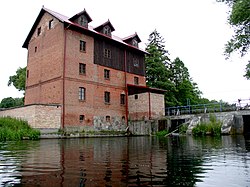
 Old watermill in Wojtal | |
| Coordinates: 53°53′38″N 18°2′3″E | |
| Country | |
| Voivodeship | Pomeranian |
| County | Chojnice |
| Gmina | Czersk |
| Population | 202 |
| Time zone | UTC+1 (CET) |
| • Summer (DST) | UTC+2 (CEST) |
| Vehicle registration | GCH |
Wojtal was a royal village of the Polish Crown, administratively located in the Tuchola County in the Pomeranian Voivodeship.[2]
During the German occupation of Poland (World War II), in 1940, the occupiers carried out expulsions of Poles, who were deported to the General Government (German-occupied central Poland), while their farms were then handed over to German colonists as part of the Lebensraum policy.[3]
Wojtal railway station is located in the village.
Seamless Wikipedia browsing. On steroids.
Every time you click a link to Wikipedia, Wiktionary or Wikiquote in your browser's search results, it will show the modern Wikiwand interface.
Wikiwand extension is a five stars, simple, with minimum permission required to keep your browsing private, safe and transparent.