Westerstetten
Municipality in Baden-Württemberg, Germany From Wikipedia, the free encyclopedia
Municipality in Baden-Württemberg, Germany From Wikipedia, the free encyclopedia
Westerstetten (Swabian: Weschdrschdett) is a village in the district of Alb-Donau in Baden-Württemberg in Germany.
Westerstetten | |
|---|---|
 | |
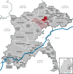
Location of Westerstetten within Alb-Donau-Kreis district  | |
| Coordinates: 48°31′13″N 9°57′19″E | |
| Country | Germany |
| State | Baden-Württemberg |
| Admin. region | Tübingen |
| District | Alb-Donau-Kreis |
| Government | |
| • Mayor (2018–26) | Alexander Bourke[1] |
| Area | |
| • Total | 13.09 km2 (5.05 sq mi) |
| Elevation | 544 m (1,785 ft) |
| Population (2022-12-31)[2] | |
| • Total | 2,228 |
| • Density | 170/km2 (440/sq mi) |
| Time zone | UTC+01:00 (CET) |
| • Summer (DST) | UTC+02:00 (CEST) |
| Postal codes | 89198 |
| Dialling codes | 0731, 07348 and 07336 |
| Vehicle registration | UL |
| Website | www.westerstetten.de |
Westerstetten is situated in the Lone valley (Lonetal) in the Swabian Jura roughly 10 km (6 mi) north of Ulm.
The neighbouring villages are, to the east, Holzkirch and Breitingen; to the south, Beimerstetten; to the southwest, Dornstadt; and to the northwest, Lonsee.

Villages incorporated to Westerstetten are Birkhof, Hinterdenkental and Vorderdenkental.
The Lone valley with its caves was a popular settlement area in the Stone Age. Westerstetten itself however has no caves, and there have been no significant finds of this period.
Since 75 AD a Roman road connected the Ad Lunam castle in Lonsee-Urspring with Aquilea at Heidenheim. As part of the Alb Limes, this road marked for some time the external border of the Roman Empire.

From 1414 to 1803, Westerstetten was part of the territory of Elchingen Abbey. When the abbey was dissolved in 1803 as part of the German Mediatisation, the village became part of Bavaria along with Elchingen. In 1810 the border between Bavaria and Württemberg was re-negotiated and Westerstetten became part of Württemberg.
At the end of the Second World War, Westerstetten was liberated by American troops in April 1945. The Jewish graves in the cemetery hold the bodies of eight Nazi concentration camp victims that were hastily buried in the Gurgelhaus forest, shortly before the end of the war.[3]
The local government reform of 1975 allowed Westerstetten to retain its independence. The designation of new building zones and its vicinity to Ulm helped it to grow to over 2,000 inhabitants.

The Stations of the Cross on the Kreuzberg were created in 1868 and inaugurated in February 1869. In 1947, today's Kreuzberg Chapel was built to replace an earlier building.
The new city hall was inaugurated 1984.
After the establishment of a new station in 2005 the old station was acquired by the municipality. It was renovated till 2007 by the modellers Westerstetten. A small railway museum documents the regional history of the station and the railway system.
A Euro City crosses the Westerstetten Station
Westerstetten lies on the railway line Stuttgart-Ulm (Fils Valley Railway and has since August 2005 the newly built railway station, which replaces the previous station. Every hour run regional trains to Ulm and Geislingen.
Railway underpass into Ulmer valley from 1848 To cross the railway line there are on Westerstetten district four possibilities: The railway bridge between the Birkhof and Vorderdenkental; 1994 renewed underpass at the entrance; the original dating from 1848, but open only for agricultural transport, cyclists and pedestrians underpass to Ulm Valley; and also from 1848 originating pedestrian underpass with stairs. At the national road network Westerstetten is well served by the national road B 10.
Until well into the 20th century Westerstetten was agricultural. Today in Westerstetten and the part places exist a few agricultural full-time farms. Much of the working people work in other areas and benefit as commuters from the good road and rail connections to Ulm. Westerstetten has numerous long-established and newly established craft and service businesses. The most visible companies is the quarry near the old station.
Westerstetten has several sports facilities, which are operated or used by clubs or are available to the public.
In Westerstetten there is a kindergarten, and a primary school. Schools are located in Dornstadt (elementary and secondary school) and in Ulm (all school types).
By belonging to the monastery Elchingen Westerstetten is traditionally predominantly Catholic, while the three districts Birkhof, front and Hinterdenkental predominantly are Protestant.

Seamless Wikipedia browsing. On steroids.
Every time you click a link to Wikipedia, Wiktionary or Wikiquote in your browser's search results, it will show the modern Wikiwand interface.
Wikiwand extension is a five stars, simple, with minimum permission required to keep your browsing private, safe and transparent.