Top Qs
Timeline
Chat
Perspective
Visconte Maggiolo
Genoese cartographer From Wikipedia, the free encyclopedia

Remove ads
Visconte Maggiolo (1478 – after 1549), also spelled Maiollo and Maiolo, was a Genoese cartographer.
He was born in Genoa and maybe he was a fellow sailor of explorer Giovanni da Verrazzano. In 1511 he moved to Naples, where he produced three extant nautical atlases.[2] Some historians say that he died of malaria in 1530; but archival documents show that he was still alive, in Genoa, at least in 1549, although he certainly was already dead in 1561.[3]
In 1527, he created a map depicting Verrazzano's travels. This map had a major error (the eponymous "Verrazzano Sea" and "Verrazzano Isthmus", which depicted a large sea, believed to be the Pacific Ocean, across a narrow isthmus on the eastern coast of North America) as Verrazzano did not accurately describe the North American continent.[4] This error continued to show up in maps for over a century. A copy of this 1527 map was destroyed during World War II.[5]
There are numerous portolan charts, atlases and at least two other world maps made by Vesconte Maggiolo: one dated Genoa, 1531;[6] another kept at a public library in Treviso (in Italian), is dated Genoa, 1549.
Although he specialized in the mapping of the Mediterranean Sea, the Black Sea and the Aegean Sea, Maggiolo was the first to report in his atlas of 1548 the toponym of the South American river Rio de Amaxones.[7]
Remove ads
Gallery
 Italy, western Sicily and the Adriatic coast
 North Africa, Europe and part of Asia
 Africa, Asia, Europe and part of the New World
 Atlantic coast of Africa and Europe, the British Isles, and Iceland
 Cosmographical planisphere, with Africa, Asia, and Europe in the center
 Dedication leaf and map of Corsica
 Greek Islands and the Aegean Sea
 West coast of Africa, including Cape Verde Islands, São Tomé, Príncipe, and Annobón
 Western Mediterranean
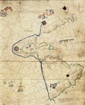 Western hemisphere


Remove ads
See also
- Egerton 2803 maps, portolan atlas attributed to Maggiolo
References
External links
Wikiwand - on
Seamless Wikipedia browsing. On steroids.
Remove ads