Varsselder
Village in Gelderland, Netherlands From Wikipedia, the free encyclopedia
Varsselder is a Dutch village situated in the Gelderland region Achterhoek, in the municipality Oude IJsselstreek. It is situated directly to the west of Ulft and it is crossed by the road from Ulft to 's-Heerenberg (N816).
Varsselder | |
|---|---|
 | |
 Varsselder Location in the Netherlands  Varsselder Varsselder (Netherlands) | |
| Coordinates: 51°53′15″N 6°21′38″E | |
| Country | Netherlands |
| Province | Gelderland |
| Municipality | Oude IJsselstreek |
| Area | |
• Total | 5.09 km2 (1.97 sq mi) |
| Elevation | 15 m (49 ft) |
| Population (2021)[1] | |
• Total | 1,080 |
| • Density | 210/km2 (550/sq mi) |
| Time zone | UTC+1 (CET) |
| • Summer (DST) | UTC+2 (CEST) |
| Postal code | 7076[1] |
| Dialing code | 0315 |
The church is called Martelaren van Gorcumkerk. The village has a former windmill.
Veldhunten is a smaller rural settlement close to Varsselder.[3]
Gallery
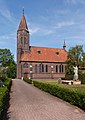 Church: Martelaren van Gorcumkerk
 Molen Lukassen
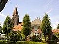 Hoofdstraat
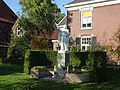 Sacred Heart statue


References
Wikiwand - on
Seamless Wikipedia browsing. On steroids.