Urubamba District
District in Cusco, Peru From Wikipedia, the free encyclopedia
Urubamba District is one of seven districts of the Urubamba province in Peru.[1]
Geography
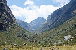
The Urupampa mountain range traverses the district. One of highest peaks of the district is Ch'iqun at 5,530 m (18,143 ft). Other mountains are listed below:[2]
- Aqu Q'asa
- Puka Q'asa
- Pumawank'a
- Qhapaq Saya
- Sut'uq
- Taruka Kancha
- T'uruhana
- Uman Urqu
Climate
| Climate data for Urubamba, elevation 2,850 m (9,350 ft), (1991–2020) | |||||||||||||
|---|---|---|---|---|---|---|---|---|---|---|---|---|---|
| Month | Jan | Feb | Mar | Apr | May | Jun | Jul | Aug | Sep | Oct | Nov | Dec | Year |
| Mean daily maximum °C (°F) | 22.2 (72.0) |
22.0 (71.6) |
22.3 (72.1) |
23.0 (73.4) |
23.4 (74.1) |
22.8 (73.0) |
22.4 (72.3) |
23.2 (73.8) |
23.6 (74.5) |
23.6 (74.5) |
23.8 (74.8) |
22.7 (72.9) |
22.9 (73.3) |
| Mean daily minimum °C (°F) | 9.5 (49.1) |
9.6 (49.3) |
9.2 (48.6) |
7.7 (45.9) |
5.0 (41.0) |
3.1 (37.6) |
2.1 (35.8) |
3.6 (38.5) |
6.0 (42.8) |
8.1 (46.6) |
8.9 (48.0) |
9.3 (48.7) |
6.8 (44.3) |
| Average precipitation mm (inches) | 105.4 (4.15) |
101.3 (3.99) |
72.0 (2.83) |
22.5 (0.89) |
4.1 (0.16) |
5.4 (0.21) |
5.4 (0.21) |
6.7 (0.26) |
7.8 (0.31) |
38.1 (1.50) |
56.4 (2.22) |
92.6 (3.65) |
517.7 (20.38) |
| Source: National Meteorology and Hydrology Service of Peru[3] | |||||||||||||
See also
References
Wikiwand - on
Seamless Wikipedia browsing. On steroids.


