Upper Kananaskis Lake
Reservoir in Kananaskis, Alberta From Wikipedia, the free encyclopedia
Upper Kananaskis Lake is a natural lake that was turned into a reservoir in Kananaskis Country in Alberta, Canada.
| Upper Kananaskis Lake | |
|---|---|
 Kananaskis Lake | |
 Upper Kananaskis Lake Location in Alberta  Upper Kananaskis Lake Upper Kananaskis Lake (Canada) | |
| Location | Kananaskis, Alberta |
| Coordinates | 50°37′05″N 115°09′15″W |
| Type | Reservoir, oligotrophic |
| Primary inflows | Upper Kananaskis River |
| Primary outflows | Lower Kananaskis Lake |
| Catchment area | 139 km2 (54 sq mi)[1] |
| Basin countries | Canada |
| Surface area | 7.8 km2 (3.0 sq mi)[1] |
| Average depth | 32 m (105 ft) |
| Max. depth | 108 m (354 ft) |
| Surface elevation | 1,720 m (5,640 ft) |
| References | [1] |
Upper Kananaskis Lake, along with the Lower Kananaskis Lake, is located in Peter Lougheed Provincial Park .
The lake is part of a series of natural and man made lakes in the Kananaskis and Bow Valleys used for hydro electric power, flood control, and water reserves for the Bow River water users such as the city of Calgary.
The lake is also used for recreational activities, with hiking paths surrounding the lake (and cross-country skiing trails in the winter).
Hiking trails
- Upper Kananaskis Lake Circuit
- Rawson Lake Trail
- Aster Lake Route (also goes to Hidden Lake)
- Three Isle Lake Trail
- Maude-Lawson Trail (To Lawson Lake)
- Mount Indefatigable Trail
- Elk Pass Trail (To Fox, Frozen, Upper Elk, and Lower Elk Lakes)
- Northover Ridge Route
Climate
Summarize
Perspective
Based on the Köppen climate classification, this vicinity is located in a subarctic climate with cold, snowy winters, and mild summers.[2] Temperatures can drop below −20 C with wind chill factors below −30 C.
| Climate data for Kananaskis Pocaterra, Alberta (1981-2010):1610m | |||||||||||||
|---|---|---|---|---|---|---|---|---|---|---|---|---|---|
| Month | Jan | Feb | Mar | Apr | May | Jun | Jul | Aug | Sep | Oct | Nov | Dec | Year |
| Record high °C (°F) | 11.5 (52.7) |
12.0 (53.6) |
16.0 (60.8) |
24.5 (76.1) |
28.5 (83.3) |
28.0 (82.4) |
32.0 (89.6) |
33.0 (91.4) |
30.0 (86.0) |
25.5 (77.9) |
15.5 (59.9) |
12.0 (53.6) |
33.0 (91.4) |
| Mean daily maximum °C (°F) | −2.8 (27.0) |
−0.4 (31.3) |
3.2 (37.8) |
7.9 (46.2) |
13.3 (55.9) |
16.9 (62.4) |
20.6 (69.1) |
20.5 (68.9) |
15.6 (60.1) |
9.4 (48.9) |
1.0 (33.8) |
−3.6 (25.5) |
8.5 (47.2) |
| Daily mean °C (°F) | −9.7 (14.5) |
−8.1 (17.4) |
−3.9 (25.0) |
1.1 (34.0) |
5.9 (42.6) |
9.4 (48.9) |
12.1 (53.8) |
11.6 (52.9) |
7.5 (45.5) |
2.4 (36.3) |
−5.0 (23.0) |
−10.1 (13.8) |
1.1 (34.0) |
| Mean daily minimum °C (°F) | −16.5 (2.3) |
−15.8 (3.6) |
−11.0 (12.2) |
−5.8 (21.6) |
−1.6 (29.1) |
1.9 (35.4) |
3.5 (38.3) |
2.7 (36.9) |
−0.8 (30.6) |
−4.6 (23.7) |
−10.9 (12.4) |
−16.5 (2.3) |
−6.3 (20.7) |
| Record low °C (°F) | −44.0 (−47.2) |
−42.0 (−43.6) |
−39.5 (−39.1) |
−25.5 (−13.9) |
−17.0 (1.4) |
−6.1 (21.0) |
−12.0 (10.4) |
−6.0 (21.2) |
−16.0 (3.2) |
−26.0 (−14.8) |
−37.0 (−34.6) |
−42.8 (−45.0) |
−44.0 (−47.2) |
| Average precipitation mm (inches) | 37.8 (1.49) |
28.5 (1.12) |
34.7 (1.37) |
44.6 (1.76) |
67.1 (2.64) |
91.5 (3.60) |
56.9 (2.24) |
56.4 (2.22) |
43.0 (1.69) |
36.6 (1.44) |
40.6 (1.60) |
30.5 (1.20) |
568.2 (22.37) |
| Average snowfall cm (inches) | 36.9 (14.5) |
28.2 (11.1) |
34.6 (13.6) |
36.3 (14.3) |
22.3 (8.8) |
2.5 (1.0) |
0.3 (0.1) |
0.3 (0.1) |
8.7 (3.4) |
18.6 (7.3) |
36.0 (14.2) |
30.6 (12.0) |
255.3 (100.4) |
| Source: Environment Canada[3] | |||||||||||||
Gallery
 Lower and Upper Kananaskis Lakes
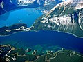 Upper and Lower Kananaskis Lakes
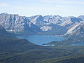 Upper Kananaskis Lake from the summit of Mount Tyrwhitt
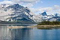 Upper Kananskis Lake and Mount Lyautey
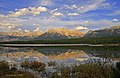 Elpoca Mountain and the Opal Range seen from Upper Kananaskis Lake


References
Wikiwand - on
Seamless Wikipedia browsing. On steroids.