Umatilla, Florida
City in Florida From Wikipedia, the free encyclopedia
City in Florida From Wikipedia, the free encyclopedia
Umatilla is a city in Lake County, Florida, United States. The population was 3,685 at the 2020 census. Umatilla is known as the Gateway to the Ocala National Forest, located in northern Lake County.[1]
Umatilla, Florida | |
|---|---|
| City of Umatilla | |
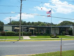
 Umatilla City Hall | |
| Motto: "Nature's Hometown"[1] | |
 Location in Lake County and the state of Florida | |
| Coordinates: 28°55′38″N 81°39′54″W | |
| Country | |
| State | |
| County | |
| Incorporated | November 8, 1904[2] |
| Government | |
| • Type | Council-Manager |
| • Mayor | Chris Creech |
| • Vice Mayor | Kent Adcock |
| • Council Members | Brian Butler, John Nichols, and Katherine "Kaye" Adams |
| • City Manager | Scott Blankenship |
| • City Clerk | Jessica Burnham |
| Area | |
| • Total | 4.27 sq mi (11.06 km2) |
| • Land | 3.59 sq mi (9.30 km2) |
| • Water | 0.68 sq mi (1.76 km2) |
| Elevation | 98 ft (30 m) |
| Population (2020) | |
| • Total | 3,685 |
| • Density | 1,026.18/sq mi (396.26/km2) |
| Time zone | UTC-5 (Eastern (EST)) |
| • Summer (DST) | UTC-4 (EDT) |
| ZIP code | 32784 |
| Area code | 352 |
| FIPS code | 12-73025[5] |
| GNIS feature ID | 2405622[4] |
| Website | www |
The city was named after Umatilla, Oregon.[2] In 1998 it was the site of a Mediterranean fruit fly outbreak at the Golden Gem citrus plant.[6]
The City of Umatilla is in northern Lake County, and its exact coordinates are located at 28°55′59″N 81°39′52″W (28.933134, –81.664430).[7]
Florida State Road 19 passes through the center of town, leading south 11 miles (18 km) to Tavares, the county seat, and north 58 miles (93 km) through the Ocala National Forest to Palatka. Umatilla is 38 miles (61 km) northwest of Orlando and 49 miles (79 km) southwest of Daytona Beach.
According to the United States Census Bureau, the city has a total area of 4.2 square miles (11.0 km2), of which 3.6 square miles (9.3 km2) are land and 0.69 square miles (1.8 km2), or 16.00%, are water.[8]
| Race | Pop 2010[10] | Pop 2020[11] | % 2010 | % 2020 |
|---|---|---|---|---|
| White (NH) | 2,938 | 2,996 | 85.01% | 81.30% |
| Black or African American (NH) | 110 | 60 | 3.18% | 1.63% |
| Native American or Alaska Native (NH) | 9 | 11 | 0.26% | 0.30% |
| Asian (NH) | 6 | 19 | 0.17% | 0.52% |
| Pacific Islander or Native Hawaiian (NH) | 0 | 2 | 0.00% | 0.05% |
| Some other race (NH) | 3 | 9 | 0.09% | 0.24% |
| Two or more races/Multiracial (NH) | 20 | 127 | 0.58% | 3.45% |
| Hispanic or Latino (any race) | 370 | 461 | 10.71% | 12.51% |
| Total | 3,456 | 3,685 | 100.00% | 100.00% |
As of the 2020 United States census, there were 3,685 people, 1,680 households, and 1,061 families residing in the city.[12]
As of the 2010 United States census, there were 3,456 people, 1,403 households, and 968 families residing in the city.[13]
As of the census[5] of 2000, there were 2,214 people, 867 households, and 582 families residing in the city. The population density was 871.4 inhabitants per square mile (336.4/km2). There were 987 housing units at an average density of 388.5 per square mile (150.0/km2). The racial makeup of the city was 93.54% White, 3.52% African American, 0.23% Native American, 0.32% Asian, 0.95% from other races, and 1.45% from two or more races. Hispanic or Latino of any race were 3.93% of the population.
In 2000, there were 867 households, out of which 29.6% had children under the age of 18 living with them, 49.8% were married couples living together, 13.1% had a female householder with no husband present, and 32.8% were non-families. 28.1% of all households were made up of individuals, and 15.0% had someone living alone who was 65 years of age or older. The average household size was 2.48 and the average family size was 3.01.
In 2000, in the city, the population was spread out, with 24.3% under the age of 18, 8.4% from 18 to 24, 26.3% from 25 to 44, 20.5% from 45 to 64, and 20.6% who were 65 years of age or older. The median age was 39 years. For every 100 females, there were 89.6 males. For every 100 females age 18 and over, there were 81.1 males.
In 2000, the median income for a household in the city was $29,628, and the median income for a family was $37,500. Males had a median income of $25,500 versus $21,741 for females. The per capita income for the city was $17,739. About 7.2% of families and 11.9% of the population were below the poverty line, including 13.9% of those under age 18 and 17.9% of those age 65 or over.
The city offers many outdoor activities such as boating, fishing, camping and hiking. Nearby Alexander Springs features a section of the Florida Trail, an unpaved hiking trail, 1,300 miles (2,100 km) long, spanning the state of Florida from north to south.
Seamless Wikipedia browsing. On steroids.
Every time you click a link to Wikipedia, Wiktionary or Wikiquote in your browser's search results, it will show the modern Wikiwand interface.
Wikiwand extension is a five stars, simple, with minimum permission required to keep your browsing private, safe and transparent.