Top Qs
Timeline
Chat
Perspective
Twin Peaks (Placer County, California)
Double summit mountain in the state of California From Wikipedia, the free encyclopedia

Remove ads
Twin Peaks is an 8,878-foot-elevation (2,706-meter) double summit mountain in Placer County, California, United States.


Remove ads
Remove ads
Description
Twin Peaks is located four miles west of Tahoe Pines and Lake Tahoe, along the boundary that Lake Tahoe Basin Management Unit shares with Granite Chief Wilderness. It is situated on the crest of the Sierra Nevada mountain range, with precipitation runoff from the peak draining east to Lake Tahoe, and west to the Rubicon River via Bear Pen Creek. Topographic relief is modest as the summit rises over 2,400 feet (730 meters) above Blackwood Canyon in 1.5 mile. Blackwood and Ward valleys, which each head near Twin Peaks and terminate at Lake Tahoe, were formed by glaciers.[8] The Alpine Meadows ski area is three miles north of Twin Peaks. The Tahoe Rim Trail traverses the south slope of the peak and the Pacific Crest Trail traverses the west slope, which provide approach options. This landform's descriptive toponym has been officially adopted by the U.S. Board on Geographic Names.[6] It was originally named "Twin Peak" by the Wheeler Survey in the 1870s and it has appeared in publications since at least 1891.[9]
Remove ads
Climate
According to the Köppen climate classification system, Twin Peaks is located in an alpine climate zone.[10] Most weather fronts originate in the Pacific Ocean and travel east toward the Sierra Nevada mountains. As fronts approach, they are forced upward by the peaks (orographic lift), causing them to drop their moisture in the form of rain or snowfall onto the range.
See also
Gallery
 East (true) summit of Twin Peaks seen from the west peak
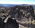 West (lower) peak of Twin Peaks seen from the east summit
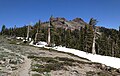 South aspect, from PCT
 East summit


References
External links
Wikiwand - on
Seamless Wikipedia browsing. On steroids.
Remove ads