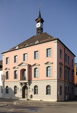
Treuchtlingen
Town in Bavaria, Germany From Wikipedia, the free encyclopedia
Town in Bavaria, Germany From Wikipedia, the free encyclopedia
Treuchtlingen is a town in the Weißenburg-Gunzenhausen district, in Bavaria, Germany. It has a population of around 12,000.
Treuchtlingen | |
|---|---|
 Town Hall | |
Location of Treuchtlingen within Weißenburg-Gunzenhausen district  | |
| Coordinates: 48°57′19″N 10°54′34″E | |
| Country | Germany |
| State | Bavaria |
| Admin. region | Mittelfranken |
| District | Weißenburg-Gunzenhausen |
| Government | |
| • Mayor (2020–26) | Kristina Becker[1] (CSU) |
| Area | |
| • Total | 103.00 km2 (39.77 sq mi) |
| Elevation | 412 m (1,352 ft) |
| Population (2023-12-31)[2] | |
| • Total | 13,181 |
| • Density | 130/km2 (330/sq mi) |
| Time zone | UTC+01:00 (CET) |
| • Summer (DST) | UTC+02:00 (CEST) |
| Postal codes | 91757 |
| Dialling codes | 09142 |
| Vehicle registration | WUG |
| Website | Official website |
The spot where the town is situated was first settled by Celts, Romans and Franks. The town proper was founded in 793, during the reign of Charlemagne, and it was first mentioned in 899, as Drutelinga. In the 12th century the castle was erected. In 1495 Treuchtlingen was burnt down. In 1869 the train station was opened.[3]
On 23 February 1945 at 11:00 clock an air raid on the station Treuchtlingen (Operation Clarion) took place, in which the Fronturlauberzug SF 2046 just stopped. The passengers of the train fled into the platform underpass, which received a direct hit.300 people died in the platform underpass, a total of nearly 600 people were killed and another 900 injured in the station and the surrounding area. Most of the bomb victims are buried in the memorial site of Kriegsgräberfürsorge on the Nagelberg. In the underpass, which tunneled the tracks elsewhere since a station renovation in 2004, a marble plaque commemorates the victims. In a second attack on April 11, 1945, no people were killed, but among other things, a steam locomotive type Bayerische G 3/4 H destroyed. Part of the wreck was found in the course of the reconstruction and is now in the Bavarian Railway Museum in Nördlingen.
Treuchtlingen is situated on the river Altmühl, 9 km southwest of Weißenburg in Bayern, and 45 km northeast of Donauwörth.
Since it is located on the European Watershed between Rhine and Danube, the municipal territory is the site of the remains of Fossa Carolina, an early Medieval attempt to bridge the watershed.
In addition to the town itself, the municipality of Treuchtlingen today includes 53 hamlets and villages. The municipal territory is divided into 12 Ortsteile (including the town) and several hamlets:
| Arms | Ortsteil | Localities included |
|---|---|---|
| Treuchtlingen | Eulenhof, Gstadt, Heunischhof, Kästleinsmühle, Metzenhof, Möhrenberg, Sägmühle, Schertnershof, Schmarrmühle, Siebeneichhöfe, Ziegelhütte | |
| Auernheim | Freihardt, Hagenhof, Schlittenhart, Wieshof | |
| Bubenheim | none | |
| Dietfurt | Bergnershof | |
| Graben | none | |
| Grönhart | Hagenau, Naßwiesen, Neuheim | |
| Gundelsheim | none | |
| Haag | Dickmühle, Hürth, Mattenmühle, Neufang, Rutzenhof, Schürmühle, Steinbruch | |
| Möhren | Eichhof, Fuchsmühle, Spielhof | |
| Schambach | Bonhof, Kohlmühle, Lehnleinsmühle, Obere Papiermühle, Untere Papiermühle, Weinbergshof | |
| Wettelsheim | Dornmühle, Falbenthal, Kellerhaus, Ziegelmühle, Zollmühle | |
| Windischhausen | Oberheumödern, Unterheumödern |
Treuchtlingen is the initial point of the Treuchtlingen-Würzburg railway.


Seamless Wikipedia browsing. On steroids.
Every time you click a link to Wikipedia, Wiktionary or Wikiquote in your browser's search results, it will show the modern Wikiwand interface.
Wikiwand extension is a five stars, simple, with minimum permission required to keep your browsing private, safe and transparent.