Tolna County
County of Hungary From Wikipedia, the free encyclopedia
County of Hungary From Wikipedia, the free encyclopedia
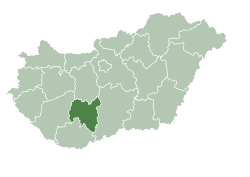
Tolna (Hungarian: Tolna vármegye, pronounced [ˈtolnɒ]; German: Komitat Tolnau) is an administrative county (comitatus or vármegye) in present-day Hungary as it was in the former Kingdom of Hungary. It lies in central Hungary, on the west bank of the river Danube. It shares borders with the Hungarian counties of Somogy, Fejér, Bács-Kiskun, and Baranya. The capital of Tolna county is Szekszárd. Its area is 3,703 km2.
Tolna County
Tolna vármegye | |
|---|---|
 Tolna County within Hungary | |
| Coordinates: 46°30′N 18°35′E | |
| Country | Hungary |
| Region | Southern Transdanubia |
| County seat | Szekszárd |
| Districts | |
| Government | |
| • President of the General Assembly | Tamás Fehérvári (Fidesz-KDNP) |
| Area | |
| • Total | 3,703.16 km2 (1,429.80 sq mi) |
| • Rank | 15th in Hungary |
| Population (2018) | |
| • Total | 219,317[1] |
| • Rank | 18th in Hungary |
| GDP | |
| • Total | HUF 592 billion €1.900 billion (2016) |
| Postal code | 702x – 7252, 7352 – 7361 |
| Area code(s) | (+36) 74, 75 |
| ISO 3166 code | HU-TO |
| Website | www |
Tolna (in Latin: comitatus Tolnensis) was also the name of a historic administrative county (comitatus) of the Kingdom of Hungary. Its territory, which was about the same as that of the present Tolna county, is now in central Hungary. The capital of the county was Szekszárd.
Religion in Tolna County (2022 census – of those eho declared their religion (62.2%))
In 2015, Tolna had a population of 225,936 and the population density was 61 inhabitants per square kilometre (160/sq mi).
| Year | County population[3] | Change |
|---|---|---|
| 1949 | 275,644 | n/a |
| 1960 | -1.29% | |
| 1970 | -4.90% | |
| 1980 | 2.90% | |
| 1990 | -4.73% | |
| 2001 | -1.57% | |
| 2011 | -7.74% | |
| 2015 | -1.95% | |
| 2018 | -3.01% |
Besides the Hungarian majority, the main minorities are the Germans (approx. 10,000) and Roma (8,500).
Total population (2011 census): 230,361
Ethnic groups (2011 census):[4]
Identified themselves: 214,953 persons:
Approx. 32,000 persons in Tolna County did not declare their ethnic group at the 2011 census.
Religious adherence in the county according to 2011 census:[5]

| No. | English and Hungarian names |
Area (km2) |
Population (2011) |
Density (pop./km2) |
Seat | No. of municipalities |
| 1 | Bonyhád District Bonyhádi járás |
476.77 | 31,567 | 66 | Bonyhád | 25 |
| 2 | Dombóvár District Dombóvári járás |
509.02 | 32,331 | 64 | Dombóvár | 16 |
| 3 | Paks District Paksi járás |
836.00 | 49,433 | 59 | Paks | 15 |
| 4 | Szekszárd District Szekszárdi járás |
656.18 | 60,122 | 92 | Szekszárd | 17 |
| 5 | Tamási District Tamási járás |
1,019.94 | 38,705 | 38 | Tamási | 32 |
| 6 | Tolna District Tolnai járás |
205.24 | 18,203 | 89 | Tolna (town) | 4 |
| Tolna County | 3,703.16 | 231,183 | 64 | Szekszárd | 109 | |
|---|---|---|---|---|---|---|
The Tolna County Council, elected at the 2024 local government elections[6], is made up of 15 counselors, with the following party composition:[7]
| Party | Seats | Current County Assembly | ||||||||
|---|---|---|---|---|---|---|---|---|---|---|
| Fidesz-KDNP | 11 | |||||||||
| Our Homeland Movement | 2 | |||||||||
| Democratic Coalition | 1 | |||||||||
| Momentum Movement | 1 | |||||||||
Tolna County has 1 urban county, 10 towns, 5 large villages and 93 villages.
(ordered by population, as of 2011 census)
Seamless Wikipedia browsing. On steroids.
Every time you click a link to Wikipedia, Wiktionary or Wikiquote in your browser's search results, it will show the modern Wikiwand interface.
Wikiwand extension is a five stars, simple, with minimum permission required to keep your browsing private, safe and transparent.