Tlilapan
Municipality and town in Veracruz, Mexico From Wikipedia, the free encyclopedia
Tlilapan is a municipality located in the central zone in the Mexican state of Veracruz, about 85 kilometres (53 mi) from the state capital of Xalapa. It has an area of 23.85 square kilometres (9.21 sq mi). It is located at 18°48′N 97°06′W. The name comes from the Náhuatl language, meaning “Black creek ". The village has existed since the 16th century and, following national independence, and was designated a municipality along with Orizaba, San Andrés Tenejapan, San Francisco Necoxtla, and San Juan del Rio. The municipal cemetery was established in 1880 and, in 1916 the first Municipal President was named.
Tlilapan | |
|---|---|
Municipality and town | |
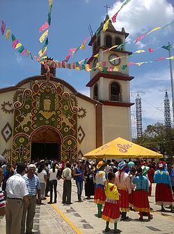
 Church of Santiago Apostol, Tlilapan | |
| Coordinates: 18°48′N 97°06′W | |
| Country | Mexico |
| State | Veracruz |
| Area | |
• Total | 23.85 km2 (9.21 sq mi) |
| Population (2005) | |
• Total | 4,536 |
| Time zone | UTC-6 (Central Standard Time) |
| • Summer (DST) | UTC-5 (Central Daylight Time) |
Geography
The municipality of Tlilapan is bordered to the north by Rafael Delgado, to the south by Huiloapan de Cuauhtémoc and to the west by Nogales .[1] It is watered by small rivers such as the Río Blanco.
The climate of Tlilapan is temperate, with abundant rainfall in summer and autumn.
Agriculture
The chief agricultural products of Tlilapan are maize, coffee and sugarcane.
Celebrations
In July, Tlilapan festival takes place the celebration of Santiago Apostol, patron of the town, and in December a celebration takes place in honor of the Virgen de Guadalupe.
References
External links
Wikiwand - on
Seamless Wikipedia browsing. On steroids.

