Tjerkgaast
Village in Friesland, Netherlands From Wikipedia, the free encyclopedia
Tjerkgaast (West Frisian: Tsjerkgaast) is a village in De Fryske Marren municipality in the province of Friesland, the Netherlands. It had a population of around 380 in 2017.[3]
Tjerkgaast
Tsjerkgaast | |
|---|---|
Village | |
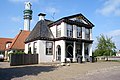
 Tjerkgaast church | |
 Location in the former Skarsterlân municipality | |
 Tjerkgaast Location in the Netherlands  Tjerkgaast Tjerkgaast (Netherlands) | |
| Coordinates: 52°54′14″N 5°40′43″E | |
| Country | Netherlands |
| Province | Friesland |
| Municipality | De Fryske Marren |
| Area | |
• Total | 19.24 km2 (7.43 sq mi) |
| Elevation | −0.6 m (−2.0 ft) |
| Population (2021)[1] | |
• Total | 350 |
| • Density | 18/km2 (47/sq mi) |
| Postal code | 8522[1] |
| Dialing code | 0514 |
History
The village was first mentioned in 1413 as Tzerckgeest, and means church on high sandy ridge.[4] Tjerkgaast is a road village which centres around the church. The church was built in 1703 as a replacement of the medieval predecessor. The western wall is a remainder of the older church. Huize Spannenburg is a neoclassical building from 1845 and has been built as a replacement of the Douma State which had been built in 1793 in Langweer.[5] In 1840, Tjerkgaast was home to 210 people.[6]
Before 2014, Tjerkgaast was part of the Skarsterlân municipality and before 1984 it was part of Doniawerstal.[6]
Gallery
 Huize Spanneburg
 The Eye statue
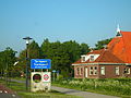 Welcome to Tjerkgaast
 Galamastate

.jpg)


References
External links
Wikiwand - on
Seamless Wikipedia browsing. On steroids.