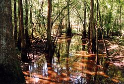
Tickfaw River
River in the United States From Wikipedia, the free encyclopedia
The Tickfaw River /ˈtɪkfɔː/ runs 113 miles (182 km)[1] from Amite County in southwest Mississippi to Livingston Parish in southeast Louisiana. Its mouth opens into Lake Maurepas, which conjoins with Lake Pontchartrain.[2]
| Tickfaw River | |
|---|---|
 | |
 Tickfaw River | |
| Location | |
| Country | United States |
| States | |
| County/Parish | |
| Physical characteristics | |
| Source | West Branch Tickfaw River |
| • location | Amite County, Mississippi |
| • coordinates | 31°03′16″N 90°37′38″W |
| • elevation | 279 ft (85 m) |
| Mouth | Lake Maurepas |
• location | Killian, Livingston Parish, Louisiana |
• coordinates | 30°20′36″N 90°28′27″W |
• elevation | −3 ft (−0.91 m) |
| Length | 113 mi (182 km) |
| Basin features | |
| Cities | |
| Tributaries | |
| • left |
|
The name Tickfaw (Tiak foha) is thought to be derived from the Choctaw phrase meaning "pine rest" or "Rest Among the Pines".[3][4] More recent analysis however has determined the name to be derived from shortening and alteration of Pawticfaw meaning "place where wild animals have shed their hair".[5] Alternate/historical names and spellings:[6]
- Rio De San Vicente
- Rio De Tickfaw
- Rio Go Tickfoha
- Rivière Ticfoha
- Ticfaw River
- Tickfah River
- Tickfaw Creek
See also
References
External links
Wikiwand - on
Seamless Wikipedia browsing. On steroids.
