Theux
Municipality in Liège Province, Belgium From Wikipedia, the free encyclopedia

Theux (French pronunciation: [tø]; Walloon: Teu) is a municipality of Wallonia located in the province of Liège, Belgium.
Theux
| |
|---|---|
.JPG) Place du Perron | |
 Flag  Coat of arms | |
Location of Theux  | |
 Theux Location in Belgium
Location of Theux in the province of Liège  | |
| Coordinates: 50°32′N 05°49′E | |
| Country | Belgium |
| Community | French Community |
| Region | Wallonia |
| Province | Liège |
| Arrondissement | Verviers |
| Government | |
| • Mayor | Pierre Lemarchand |
| • Governing party/ies | Intérêts franchimontois réunis (IFR) |
| Area | |
• Total | 83.48 km2 (32.23 sq mi) |
| Population (2018-01-01)[1] | |
• Total | 12,025 |
| • Density | 140/km2 (370/sq mi) |
| Postal codes | 4910 |
| NIS code | 63076 |
| Area codes | 087 |
| Website | www.theux.be |
On 1 January 2006 the municipality had 11,571 inhabitants. The total area is 83.36 km2, giving a population density of 139 inhabitants per km2.
The municipality consists of the following districts: La Reid, Polleur, and Theux (including the hamlet of Tancrémont).
History
In World War II, the 75th Division of the U.S. Army, 575th Signal Co., maintained its command post in the town from January 10–12, 1945, as it counterattacked against the German army in the Battle of the Bulge.
Notable buildings
- Franchimont Castle is located in Theux municipality.
- A Perron, symbol of the town's status.
- Shrine of Tancrémont, in the hamlet of Tancrémont.
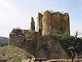 Franchimont Castle
 Theux Perron
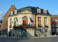 Town Hall of Theux


.JPG)
See also
References
External links
Wikiwand - on
Seamless Wikipedia browsing. On steroids.