Top Qs
Timeline
Chat
Perspective
Tanjungbalai (city)
City in North Sumatra, Indonesia From Wikipedia, the free encyclopedia

Remove ads
Tanjungbalai[fn 1], also colloquially written as Tanjung Balai, is a city in North Sumatra province, Indonesia, on the estuary of the Asahan River. It has an area of 60.52 square kilometers (23.37 sq mi) and the sixth largest kota (urban) population in North Sumatra with 154,445 inhabitants in the 2010 census[2] and 176,027 at the 2020 Census;[3] the official estimate as at mid 2023 was 183,170 - comprising 92,715 males and 90,455 females.[1] The town has a ferry terminal with services to Port Klang, Malaysia, and the city-island of Singapore.


Remove ads
Formerly known as Tanjungbalai-Asahan, this area was once a district within Asahan Regency until it was granted city status in 1984. However, the identifier "Asahan" is still used to distinguish it from the port of the same name on Great Karimun island. After the separation of Tanjungbalai from Asahan Regency, it technically became an enclave within the regency.
Remove ads
Administrative divisions
The city is divided administratively into six districts (kecamatan), tabulated below with their areas and their populations at the 2010 Census [2] and 2020 Census,[3] together with the official estimates as at mid 2023.[1] The table also includes the number of administrative villages in each district (all classed as urban kelurahan) and its post codes.
Remove ads
Tanjungbalai Asahan Port (Teluk Nibung Port)
The Port (which actually lies in Tanjungbalai District of Asahan Regency, between the city and the coast) has warehouse facilities and stacking fields. This port also carries out cargo and passenger services with activities mainly in exporting vegetables and fish to Malaysia. The port has passenger services to Port Klang and Port of Melintang Forest, Perak. Teluk Nibung passenger terminal currently has an area of about 2,500 square metres, consisting of two floors with a capacity of around 800 people. 1st floor for check-in, customs, immigration for arrivals, VIP rooms, quarantine rooms and 2nd floor for immigration rooms for departures, passenger waiting rooms, food court and coffee shops.[4][5]
Remove ads
Climate
Tanjungbalai has a tropical rainforest climate (Af) with moderate rainfall from January to July and heavy rainfall from August to December.
Gallery
 Tanjungbalai in 1895
 View of a bridge, 1926
 Bridge at Silau river, 1900s
 View of the city, 1895
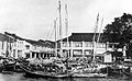 Fishing port in Tanjungbalai, 1900s
 Welcome to Tanjungbalai signboard
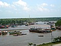 Sei Asahan Bridge
 Tanjungbalai railway station
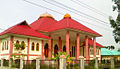 Replica of the former Sultan palace
 Sirantau Batak Protestant church


.jpg)
References
Notes
Wikiwand - on
Seamless Wikipedia browsing. On steroids.
Remove ads