Top Qs
Timeline
Chat
Perspective
Taedong River
River in North Korea From Wikipedia, the free encyclopedia

Remove ads
The Taedong River (Korean: 대동강)[a] is a large river in North Korea. The river rises in the Rangrim Mountains of the country's north where it then flows southwest into Korea Bay at Namp'o.[3] In between, it runs through the country's capital, Pyongyang. Along the river are landmarks such as the Juche Tower and Kim Il-sung Square.

The river is 439 kilometres (273 miles) in length, and is generally deep. It is the fifth-longest river on the Korean peninsula and the second-longest in North Korea. Pyongyang is approximately 110 km upstream from the mouth, Sunchon 192 km upstream, and Taehŭng 414 km upstream.[citation needed] Because of its depth, it is widely used for river transport; it is navigable by large ships up to 65 km inland, although most commercial traffic stops at Songrim.
Remove ads
History
The kingdom of Koguryo was founded on its shores. Many archeological sites dating to the Neolithic and Bronze Age have been found along the river, as well as relics and ruins from Koguryo. It was also once known as the Pae River (패수; 浿水; P’aesu).[4]
Dams and bridges
In 1954, a bridge going over the Taedong River was partially destroyed during the Korean War. Despite the damage to the bridge, several hundred Koreans used it to cross the Taedong and flee south.[5] Max Desfor's photograph of the event, Flight of Refugees Across Wrecked Bridge in Korea, would win the 1951 Pulitzer Prize in Photography.[6]
In 1986, the government completed the 8-km-long West Sea Barrage, with three locks and 36 sluices, at the mouth of the Taedong River near Namp'o.[3] The dam acts to control floodwater and to irrigate lands newly reclaimed from the Korea Gulf.[3] The dam prevents mixing of the outgoing river water with seawater, leading to an increase of contaminants concentration.[7] Other dams, such as the Nyongwon Power Station, have been built to provide energy to the country.[8]
In Pyongyang, there are six bridges on the Taedong, including the Okryu Bridge, Rungra Bridge, and Taedong Bridge.[9]
Remove ads
Gallery
 Yanggakdo Island in the middle of the river in Pyongyang
 The Taedong River flowing through Pyongyang
 An image of the Taedong River from 1889
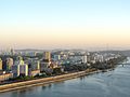 The Taedong in Pyongyang
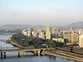 Another view of the river through Pyongyang
 The Grand People's Study House on the bank of the river


 Monument to the General Sherman incident
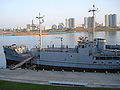 The captured USS Pueblo vessel moored on the Taedong (now tied up on the Botong River beside the Victorious Fatherland Liberation War Museum)
 The Taedong River in Nampo
 The river in Nampo


.jpg)


.jpg)
_01.JPG)


Notes
References
See also
Wikiwand - on
Seamless Wikipedia browsing. On steroids.
Remove ads