Tabuk, Saudi Arabia
City in Tabuk, Saudi Arabia From Wikipedia, the free encyclopedia

Tabuk (Arabic: تَبُوْك Tabūk, Arabic: [taˈbu:k]) is the capital city of the Tabuk Province in northwestern Saudi Arabia. It has a population of 594,350 (as of 2022). It is close to the Jordan–Saudi Arabia border and houses the largest air force base in Saudi Arabia.[3]
Tabuk
تَبُوْك | |
|---|---|
 Skyline of Tabuk | |
 Tabuk Location in Saudi Arabia  Tabuk Tabuk (Middle East)  Tabuk Tabuk (West and Central Asia) | |
| Coordinates: 28°23′50″N 36°34′44″E | |
| Country | Saudi Arabia |
| Province | Tabuk |
| Governorate | Tabuk |
| Elevation | 760 m (2,490 ft) |
| Population (2022 census)[1] | |
| 594,350 | |
| • Metro | 623,665 (Tabuk Governorate) |
| GDP (PPP, constant 2015 values) | |
| • Year | 2023 |
| • Total (Metro) | $29.6 billion[2] |
| • Per capita | $43,100 |
| Time zone | UTC+3 (AST) |
| Area code | +966 14 |
History and prehistory
Summarize
Perspective

The historical place of Midian roughly corresponds to what is now region of Tabuk.[4] Tabuk Castle, known as the castle of Aṣ-ḥāb al-Aykah ("Companions of the Wood"), is mentioned in the Quran.[5][6][7][8] The castle dates back to about 3500 BCE and has been restored many times; the last was in 1652. Several forts and stations were built along the Syrian pilgrimage route, from the Jordanian border to Medina to welcome the pilgrims. The fort consists of two floors built around an open courtyard with a mosque, a well, and a stairway leading to the watch towers used by the guards. Tabuk Castle is considered an archaeological landmark of the region and is open to visitors.
Ptolemy mentioned a place by the name 'Tabawa', at the northwestern corner of Arabia. This name may be a reference to 'Tabuka' or 'Tabuk'. If this is true, the town may be as old as Ptolemy's time. Pre-Islamic Arab poets such as Antra and Nabiqa mention the mountain 'Hasmi' in their poems.[citation needed]
Tabouk became famous for the Expedition of Tabuk in 630, during the period of the Islamic prophet Muhammad. Since then, it remained a gateway to North Arabia. It was visited by Charles Montagu Doughty in 1877.
Tabuk was captured by the Arab forces in 1918, three weeks after the British capture of Damascus.[9] Tabuk became a centre of military activity during the 1991 Gulf War as the city faced threats from Iraqi Scud missiles and air attacks[citation needed].
The region is rich in antiquities and archaeological sites such as petroglyphs, inscriptions, forts, palaces, walls, the Syrian-Egyptian pilgrimage route, and the remains of the Hejaz railway, the main station of which is located in Tabuk.
Hundreds of localities with rock art and inscriptions dating to different chronological periods and ranging from the Paleolithic to the Islamic period were recorded at Wadi Dam and the region west of Tabuk. A study of the art revealed rich stylistic variability and both human and animal figures were represented in it. Numerous sites in the area with Thamudic, Greek and Nabataean inscriptions have been found.
Ain Sukkrah is an ancient ‘ayn (Arabic: عَيْن, romanized: spring) dating back to Pre-Islamic Arabia ("Era of Ignorance"). During the expedition of Tabuk, it was remembered that Muhammad camped for more than ten days near the spring and drank from its water.[10]
Demographics
In 1950, Tabuk had a population of 12,000. By 2022, this number had grown to 594,350.[1]
Education
Universities include:
- University of Tabuk
- Fahad bin Sultan University
Private schools include:
- British International School of Tabuk
- International Indian School Tabuk
- Pakistan International School of Tabuk
- Philippine International School
- King Abdulaziz Model schools
- Tabuk International School
- Bangladesh International School, Tabuk
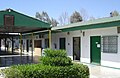 British International School of Tabuk


Geography and climate
.jpg)
| Climate data for Tabuk (1991–2020) | |||||||||||||
|---|---|---|---|---|---|---|---|---|---|---|---|---|---|
| Month | Jan | Feb | Mar | Apr | May | Jun | Jul | Aug | Sep | Oct | Nov | Dec | Year |
| Record high °C (°F) | 28 (82) |
29 (84) |
35 (95) |
37 (99) |
41 (106) |
42 (108) |
44 (111) |
44 (111) |
41 (106) |
38 (100) |
33 (91) |
28 (82) |
44 (111) |
| Mean daily maximum °C (°F) | 17.7 (63.9) |
20.6 (69.1) |
24.9 (76.8) |
29.5 (85.1) |
33.8 (92.8) |
36.9 (98.4) |
38.2 (100.8) |
38.7 (101.7) |
36.1 (97.0) |
31.1 (88.0) |
23.8 (74.8) |
18.9 (66.0) |
29.2 (84.5) |
| Daily mean °C (°F) | 10.5 (50.9) |
13.1 (55.6) |
17.3 (63.1) |
21.8 (71.2) |
26.2 (79.2) |
29.3 (84.7) |
30.9 (87.6) |
31.2 (88.2) |
28.4 (83.1) |
23.4 (74.1) |
16.7 (62.1) |
11.7 (53.1) |
21.7 (71.1) |
| Mean daily minimum °C (°F) | 3.3 (37.9) |
5.3 (41.5) |
8.7 (47.7) |
12.9 (55.2) |
17 (63) |
20 (68) |
22 (72) |
22.2 (72.0) |
19.3 (66.7) |
15.1 (59.2) |
9.6 (49.3) |
4.7 (40.5) |
13.3 (56.1) |
| Record low °C (°F) | −7 (19) |
−7 (19) |
−4 (25) |
0 (32) |
7 (45) |
11 (52) |
15 (59) |
15 (59) |
10 (50) |
5 (41) |
−3 (27) |
−6 (21) |
−7 (19) |
| Average precipitation mm (inches) | 9.1 (0.36) |
2.3 (0.09) |
4.4 (0.17) |
1.2 (0.05) |
1.8 (0.07) |
0.1 (0.00) |
0.1 (0.00) |
0.8 (0.03) |
0.1 (0.00) |
2.9 (0.11) |
3.3 (0.13) |
1.7 (0.07) |
27.8 (1.09) |
| Average precipitation days (≥ 1.0 mm) | 1.0 | 0.7 | 0.8 | 0.3 | 0.5 | 0.0 | 0.0 | 0.1 | 0.0 | 0.7 | 0.5 | 0.4 | 5.0 |
| Average relative humidity (%) | 51 | 42 | 35 | 27 | 24 | 22 | 22 | 24 | 27 | 34 | 43 | 51 | 34 |
| Average dew point °C (°F) | 0 (32) |
−1 (30) |
0 (32) |
0 (32) |
2 (36) |
4 (39) |
6 (43) |
7 (45) |
6 (43) |
5 (41) |
3 (37) |
1 (34) |
3 (37) |
| Mean monthly sunshine hours | 263.5 | 251.4 | 282.1 | 282.0 | 300.7 | 348.0 | 368.9 | 347.2 | 306.0 | 288.3 | 252.0 | 244.9 | 3,535 |
| Mean daily sunshine hours | 8.5 | 8.9 | 9.1 | 9.4 | 9.7 | 11.6 | 11.9 | 11.2 | 10.2 | 9.3 | 8.4 | 7.9 | 9.7 |
| Source 1: World Meteorological Organization,[11] Jeddah Regional Climate Center (humidity 1985-2010)[12] (Red Sea International Airport) | |||||||||||||
| Source 2: Deutscher Wetterdienst (sun 1986-1990),[13] Time and Date (dewpoints, 1985-2015) | |||||||||||||
Transportation
Tabuk Regional Airport is served by Saudia[14] and other airlines, with both domestic and international destinations.[15]
See also
- 1068 Near East earthquake, catastrophic event whose epicentre was in the area of Tabuk[16]
- Al-Hijr Archaeological Site (Hegra)
- AlUla
- Rakuba
- Mawqaq
- Hejaz
References
External links
Wikiwand - on
Seamless Wikipedia browsing. On steroids.