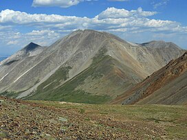
Tabeguache Peak
Mountain in the state of Colorado, United States From Wikipedia, the free encyclopedia
Mountain in the state of Colorado, United States From Wikipedia, the free encyclopedia
Tabeguache Peak is one of the fourteeners of the US state of Colorado. It is a near neighbor of the higher peak Mount Shavano, which lies approximately 1/2 mile (approximately 1 km) to the southeast. According to William Bright an American Linguist specialized in Native American and South Asian languages and descriptive linguistics it is pronounced "TAB-uh-wahch" (/tæbəwɑːtʃ/ ).[6] According to Mountaineer Louis Dawson the name is pronounced "tab-uh-wash," with the accent on the first syllable.[7] It lies just east of the Continental Divide and just west of the Arkansas River, in the south-central part of the Sawatch Range. It is located within the San Isabel National Forest and is in Chaffee County.
| Tabeguache Peak | |
|---|---|
 Tabeguache Peak viewed from the west | |
| Highest point | |
| Elevation | 14,157.0 ft (4,315.1 m)[1] NAPGD2022 |
| Prominence | 455 ft (139 m)[2] |
| Isolation | 0.75 mi (1.21 km)[2] |
| Listing | Colorado Fourteener 25th |
| Coordinates | 38°37′32″N 106°15′03″W[3] |
| Geography | |
| Location | Chaffee County, Colorado, U.S.[4] |
| Parent range | Sawatch Range[2] |
| Topo map(s) | USGS 7.5' topographic map Saint Elmo, Colorado[3] |
| Climbing | |
| Easiest route | Via Mt. Shavano: Hike, class 2[5] |
The mountain is named for the Tabeguache band of the Utes. "Tabaguache" means 'People of Sun Mountain', from "Tava" meaning 'sun.'[8][9]
It is frequently climbed with its neighbor Mount Shavano. The standard route combining both peaks is rated Class 2.[10]
| Climate data for Tabeguache Peak 38.6267 N, 106.2516 W, Elevation: 13,648 ft (4,160 m) (1991–2020 normals) | |||||||||||||
|---|---|---|---|---|---|---|---|---|---|---|---|---|---|
| Month | Jan | Feb | Mar | Apr | May | Jun | Jul | Aug | Sep | Oct | Nov | Dec | Year |
| Mean daily maximum °F (°C) | 22.1 (−5.5) |
21.5 (−5.8) |
26.4 (−3.1) |
31.6 (−0.2) |
40.4 (4.7) |
52.2 (11.2) |
57.5 (14.2) |
55.4 (13.0) |
49.4 (9.7) |
39.2 (4.0) |
28.6 (−1.9) |
22.4 (−5.3) |
37.2 (2.9) |
| Daily mean °F (°C) | 10.4 (−12.0) |
9.5 (−12.5) |
13.9 (−10.1) |
18.7 (−7.4) |
27.4 (−2.6) |
38.0 (3.3) |
43.4 (6.3) |
42.0 (5.6) |
36.0 (2.2) |
26.6 (−3.0) |
17.4 (−8.1) |
11.0 (−11.7) |
24.5 (−4.2) |
| Mean daily minimum °F (°C) | −1.3 (−18.5) |
−2.5 (−19.2) |
1.4 (−17.0) |
5.8 (−14.6) |
14.4 (−9.8) |
23.7 (−4.6) |
29.4 (−1.4) |
28.5 (−1.9) |
22.7 (−5.2) |
13.9 (−10.1) |
6.2 (−14.3) |
−0.4 (−18.0) |
11.8 (−11.2) |
| Average precipitation inches (mm) | 3.22 (82) |
3.27 (83) |
3.52 (89) |
4.28 (109) |
2.84 (72) |
1.23 (31) |
2.88 (73) |
2.49 (63) |
2.20 (56) |
2.37 (60) |
2.80 (71) |
3.00 (76) |
34.1 (865) |
| Source: PRISM Climate Group[11] | |||||||||||||
Seamless Wikipedia browsing. On steroids.
Every time you click a link to Wikipedia, Wiktionary or Wikiquote in your browser's search results, it will show the modern Wikiwand interface.
Wikiwand extension is a five stars, simple, with minimum permission required to keep your browsing private, safe and transparent.