Sugar Pine, California
Unincorporated community in California, United States From Wikipedia, the free encyclopedia
Sugar Pine is an unincorporated community in Madera County, California.[1] It is located 5 miles (8 km) north of Yosemite Forks,[2] at an elevation of 4236 feet (1291 m).[1] It is located 1 mile east of California State Route 41, between Oakhurst, California and the South Entrance of Yosemite National Park.
Sugar Pine | |
|---|---|
 Sugar Pine Location in California  Sugar Pine Sugar Pine (the United States) | |
| Coordinates: 37°26′28″N 119°38′04″W | |
| Country | United States |
| State | California |
| County | Madera County |
| Elevation | 4,236 ft (1,291 m) |
Sugar Pine was built by the Madera Sugar Pine Company in 1899 to 1900.[2] The company which had an extensive logging operation in the area between the 1890s and 1931. The mill pond and some service buildings are all that remain of the mill. The company housing units, over the years updated, are still in use today as residences and vacation homes.
A post office operated at Sugar Pine from 1907 to 1934.[2]
Notable People
Gallery
 The first mill at Sugar Pine around 1920.[3]
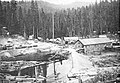
 The Madera Sugar Pine company expanded the Sugar Pine Mill complex after a catastrophic fire in 1922.[3]
 Several flume sections leave the mill to converge into one v-shaped trough for the 54-mile run to Madera, California.[3]


References
Wikiwand - on
Seamless Wikipedia browsing. On steroids.