Somogyvámos
Village in Southern Transdanubia, Hungary From Wikipedia, the free encyclopedia
Village in Southern Transdanubia, Hungary From Wikipedia, the free encyclopedia
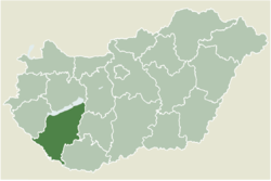
Somogyvámos is a village in Somogy county, Hungary. It is about 25 km north of Kaposvár, and about 25 km south of Fonyód.
Somogyvámos | |
|---|---|
Village | |
 The Pusztatemplom | |
 Location of Somogy county in Hungary | |
| Coordinates: 46.57040°N 17.68041°E | |
| Country | |
| Region | Southern Transdanubia |
| County | Somogy |
| District | Fonyód |
| RC Diocese | Kaposvár |
| Area | |
| • Total | 25.02 km2 (9.66 sq mi) |
| Population (2017) | |
| • Total | 744[1] |
| Demonym(s) | vámosi, somogyvámosi |
| Time zone | UTC+1 (CET) |
| • Summer (DST) | UTC+2 (CEST) |
| Postal code | 8699 |
| Area code | (+36) 85 |
| Patron Saint | Prince Emeric |
| NUTS 3 code | HU232 |
| MP | József Attila Móring (KDNP) |
| Website | Somogyvámos Online |
The surrounding lands were inhabited since the Avaric rule (6th/7th century). Its first written mention is from 1237, as "Csopak", which is now a name of a different town about 80–100 km away. The village was destroyed during the Ottoman rule and was inherited by the neighbouring village "Vámos", hence the current name, with the "Somogy" prefix, to distinguish it from the other "-vámos" named places. Vámos had slowly "moved" to the current place it lies and sometime in history changed its name to Somogyvámos.
The ruins of a 12th-century church located near the village (pictured inset) also indicate that the area was settled in during the early Middle Ages.[2]

Seamless Wikipedia browsing. On steroids.
Every time you click a link to Wikipedia, Wiktionary or Wikiquote in your browser's search results, it will show the modern Wikiwand interface.
Wikiwand extension is a five stars, simple, with minimum permission required to keep your browsing private, safe and transparent.