Loading AI tools
Local government area in Western Australia From Wikipedia, the free encyclopedia
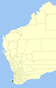
The Shire of Augusta Margaret River is a local government area in the south-west corner of the South West region of Western Australia, approximately 270 kilometres (168 mi) south of Perth. The shire covers an area of 2,243 square kilometres (866 sq mi) and had a population of over 14,000 at the 2016 Census, about half of whom live in the towns of Margaret River and Augusta.
| Shire of Augusta Margaret River Western Australia | |||||||||||||||
|---|---|---|---|---|---|---|---|---|---|---|---|---|---|---|---|
 Location in Western Australia | |||||||||||||||
 | |||||||||||||||
| Established | 1891 | ||||||||||||||
| Area | 2,242.6 km2 (865.9 sq mi) | ||||||||||||||
| Shire President | Julia Meldrum[1] | ||||||||||||||
| Council seat | Margaret River | ||||||||||||||
| Region | South West | ||||||||||||||
| State electorate(s) | Vasse, Warren-Blackwood | ||||||||||||||
| Federal division(s) | Forrest | ||||||||||||||
 | |||||||||||||||
| Website | Shire of Augusta Margaret River | ||||||||||||||
| |||||||||||||||
Nearly half of Augusta Margaret River's land area is state forest or national park. National parks include Scott National Park and Leeuwin-Naturaliste National Park. Other land uses include agriculture, especially dairy and beef cattle; viticulture; and tourism.
It was first gazetted as the Augusta Road District on 16 April 1891 and was renamed to Augusta-Margaret River Road District on 10 September 1926. On 1 July 1961, it became a shire under the Local Government Act 1960.[2] In 2017 it abolished its system of wards for electing councillors.[3]
| Party | Candidate | Votes | % | ±% | |
|---|---|---|---|---|---|
| Independent | Kylie Kennaugh (elected) | 1,137 | 26.04 | ||
| Independent | Nikki Jones (elected) | 858 | 19.65 | ||
| Independent | Paula Cristoffanini (elected) | 732 | 16.76 | ||
| Independent | Greg Boland | 672 | 15.39 | ||
| Independent | Melissa Rose D'Ath | 580 | 13.28 | ||
| Independent | Reg Gillard | 275 | 6.30 | ||
| Independent | Diane Fisher | 113 | 2.59 | ||
| Total formal votes | 4,367 | 99.57 | |||
| Informal votes | 19 | 0.43 | |||
| Turnout | 4,386 | 34.69 | |||
The majority of the Shire of Augusta–Margaret River is located on the traditional land of the Wardandi people,[5][6] except for the eastern part of the shire which is located on the land of the Bibulman (also spelled Pibelmen) people, both of the Noongar nation.[7][8][9]
The towns and localities of the Shire of Augusta–Margaret River with population and size figures based on the most recent Australian census:[10][11]
| Locality | Population | Area | Map |
|---|---|---|---|
| Alexandra Bridge | 3 (SAL 2021)[12] | 6.6 km2 (2.5 sq mi) |  |
| Augusta | 1,463 (SAL 2021)[13] | 37.8 km2 (14.6 sq mi) |  |
| Baudin | 0 (SAL 2016)[14][15] | 343.8 km2 (132.7 sq mi) |  |
| Boranup | 4 (SAL 2016)[16][17] | 106.5 km2 (41.1 sq mi) |  |
| Bramley | 113 (SAL 2021)[18] | 50.4 km2 (19.5 sq mi) |  |
| Burnside | 309 (SAL 2021)[19] | 19.5 km2 (7.5 sq mi) |  |
| Courtenay | 55 (SAL 2021)[20] | 65.2 km2 (25.2 sq mi) |  |
| Cowaramup | 2,482 (SAL 2021)[21] | 95.8 km2 (37.0 sq mi) |  |
| Deepdene | 56 (SAL 2021)[22] | 39.6 km2 (15.3 sq mi) |  |
| East Augusta | 41 (SAL 2021)[23] | 5 km2 (1.9 sq mi) |  |
| Forest Grove | 253 (SAL 2021)[24] | 127.9 km2 (49.4 sq mi) |  |
| Gnarabup | 525 (SAL 2021)[25] | 2.5 km2 (0.97 sq mi) |  |
| Gracetown | 238 (SAL 2021)[26] | 32.6 km2 (12.6 sq mi) |  |
| Hamelin Bay | 58 (SAL 2021)[27] | 16.6 km2 (6.4 sq mi) |  |
| Karridale | 317 (SAL 2021)[28] | 99.3 km2 (38.3 sq mi) |  |
| Kudardup | 110 (SAL 2021)[29] | 57.6 km2 (22.2 sq mi) |  |
| Leeuwin | 4 (SAL 2021)[30] | 21.8 km2 (8.4 sq mi) |  |
| Margaret River | 8,918 (SAL 2021)[31] | 61.3 km2 (23.7 sq mi) |  |
| Molloy Island | 163 (SAL 2021)[32] | 2.9 km2 (1.1 sq mi) |  |
| Nillup | 61 (SAL 2021)[33] | 36.9 km2 (14.2 sq mi) |  |
| Osmington | 163 (SAL 2021)[34] | 34.5 km2 (13.3 sq mi) |  |
| Prevelly | 205 (SAL 2021)[35] | 2.4 km2 (0.93 sq mi) |  |
| Redgate | 98 (SAL 2021)[36] | 23.6 km2 (9.1 sq mi) |  |
| Rosa Brook | 216 (SAL 2021)[37] | 65.5 km2 (25.3 sq mi) |  |
| Rosa Glen | 188 (SAL 2021)[38] | 66.3 km2 (25.6 sq mi) |  |
| Schroeder * | 0 (SAL 2016)[39][40] | 531.7 km2 (205.3 sq mi) |  |
| Scott River | 46 (SAL 2021)[41] | 136.4 km2 (52.7 sq mi) |  |
| Treeton | 153 (SAL 2021)[42] | 118.4 km2 (45.7 sq mi) |  |
| Warner Glen | 63 (SAL 2021)[43] | 28.3 km2 (10.9 sq mi) |  |
| Witchcliffe | 484 (SAL 2021)[44] | 54.7 km2 (21.1 sq mi) |  |
| Yebble | [1] | 18.1 km2 (7.0 sq mi) |  |
The historical figures for the population of the shire have been recorded in the census as follows:[45][46]
|
|
As of 2023, 143 places are heritage-listed in the Shire of Augusta–Margaret River,[47] of which eleven are on the State Register of Heritage Places, among them the Cape Leeuwin Lighthouse, Wallcliffe House and Ellensbrook.[48]
Seamless Wikipedia browsing. On steroids.
Every time you click a link to Wikipedia, Wiktionary or Wikiquote in your browser's search results, it will show the modern Wikiwand interface.
Wikiwand extension is a five stars, simple, with minimum permission required to keep your browsing private, safe and transparent.