Sherpur Upazila
Upazila in Rajshahi, Bangladesh From Wikipedia, the free encyclopedia
Sherpur Upazila (Bengali: শেরপুর উপজেলা) is an upazila (subdistrict) of Bogra District in Rajshahi Division, Bangladesh. Sherpur Thana was established in 1962 and was converted into an upazila in 1983.[5] It is named after its administrative center, the town of Sherpur.
Sherpur
শেরপুর | |
|---|---|
 Kherua Mosque | |
.svg) | |
| Coordinates: 24°40′N 89°25′E | |
| Country | Bangladesh |
| Division | Rajshahi |
| District | Bogra |
| Area | |
• Total | 295.93 km2 (114.26 sq mi) |
| Population | |
• Total | 383,539 |
| • Density | 1,300/km2 (3,400/sq mi) |
| Time zone | UTC+6 (BST) |
| Postal code | 5840[3] |
| Area code | 051[4] |
| Website | sherpur |
Geography
Sherpur Upazila has a total area of 295.93 square kilometres (114.26 sq mi).[1] It borders Shajahanpur Upazila to the north, Dhunat Upazila to the east, Sirajganj District to the south, Natore District to the south and west, and Nandigram Upazila to the west.[5]
Demographics
| Year | Pop. (000) | ±% |
|---|---|---|
| 1991 | 229 | — |
| 2001 | 286 | +24.9% |
| 2011 | 333 | +16.4% |
| 2022 | 386 | +15.9% |
| 2025 | 400 | +3.6% |
| Source: Bangladesh Bureau of Statistics[1] | ||
According to the 2011 Census of Bangladesh, Sherpur Upazila had 81,753 households and a population of 332,825. 68,049 (20.45%) were under 10 years of age. Sherpur had a literacy rate (age 7 and over) of 43.03%, compared to the national average of 51.8%, and a sex ratio of 1011 females per 1000 males. 54,082 (16.25%) lived in urban areas.[1] Ethnic population was 3,603 (1.08%).[6]
Religion
Islam is the dominant religion of Sherpur Upazila.
Notable sites
- Kherua Mosque, built in 1582, is an example of early Mughal architecture in Bengal. It is a symmetrical, single-aisled, three-bayed mosque with three domes.[8]
- Bhabanipur Shaktipeeth, one of seven Shakti Peethas in Bangladesh, is a sacred site for the followers of Hinduism.[9]
- Landscapes of Sherpur Upazila
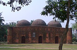 Kherua Mosque
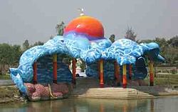 Saudia City Park is an amusement park in Sherpur
 Freedom Fighter's Grave (Mass killing site at Darimokunda)
 Village road in Autumn Season in Sherpur


Economy
Main sources of income Agriculture 61.33%, non-agricultural labourer 2.97%, industry 1.44%, commerce 14.50%, transport and communication 4.47%, service 5.79%, construction 1.88%, religious service 0.16%, rent and remittance 0.27% and others 7.19%. Agricultural land Landowner 50.08%, landless 49.92%; agricultural landowner: urban 31.78% and rural 53.29%.'
Administration
Administration Sherpur Thana was formed in 1962 and it was turned into an upazila in 1983. Sherpur Upazila is divided into Sherpur Municipality and 10 union parishads. The union parishads are:
- Bhabanipur Union Parishad
- Bishalpur Union Parishad
- Garidaha Union Parishad
- Khamarkandi Union Parishad
- Khanpur Union Parishad
- Kusumbi Union Parishad
- Mirzapur Union Parishad
- Shah-Bandegi Union Parishad
- Shimabari Union Parishad
- Sughat Union Parishad
The union parishads are subdivided into 220 mauzas and 322 villages.
In the 2009 upazila elections, Md Mujibur Rahman Majanu was elected Upazila Chairman, while MA Halim and Mosammat Ajmi Ara Parveenwere elected vice chairmen.[10] The Upazila Nirbahi Officer (UNO), who administers the upazila for the central government, is AKM Sarwar Jahan.[11]
Sherpur Municipality is subdivided into 9 wards and 19 mahallas.[1]
Education
There is a government college, eight non-government general colleges, five non-government technical colleges, 42 secondary schools, and three institutes in the upazila. Among them are 42 madrasas.[12] Average literacy is 36.3%; male 41.5%, female 31%.[citation needed]
Local schools include Dhankundi Shahnaj Siraj High School and Polli Unnayan Academy Laboratory School & College
See also
References
Wikiwand - on
Seamless Wikipedia browsing. On steroids.