Santander de Quilichao
City in Cauca Department, Colombia From Wikipedia, the free encyclopedia
Santander de Quilichao is a city in the north of the Cauca Department, Colombia at 97 km to the north of Popayán and 45 km to the south of Cali.
This article needs additional citations for verification. (January 2021) |
Santander de Quilichao | |
|---|---|
City | |
 | |
| Nickname: City of the Samanes | |
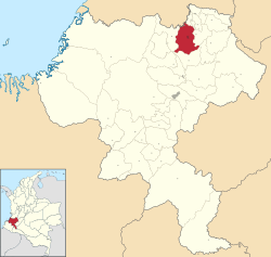
 Location of the city Santander de Quilichao. | |
| Coordinates: 3°00′47″N 76°19′12″W | |
| Country | Colombia |
| Department | Cauca Department |
| Founded | July 16, 1543 |
| Government | |
| • Mayor | Luís Eduardo Grijalba |
| Area | |
• City | 518.2 km2 (200.1 sq mi) |
| • Urban | 10.880 km2 (4.201 sq mi) |
| Elevation | 1,071 m (3,514 ft) |
| Population (2023)[1] | |
• City | 220,000 |
| • Density | 420/km2 (1,100/sq mi) |
| • Urban | 180,000 |
| • Urban density | 17,000/km2 (43,000/sq mi) |
| • Metro | 180,000 |
| Demonym | Quilichagüeño |
| Time zone | UTC-5 (Colombia Standard Time) |
| Area code | 57 + 2 |
| Climate | Af |
| Website | Official website (in Spanish) |
Climate
| Climate data for Santander de Quilichao (Japio), elevation 1,015 m (3,330 ft), (1981–2010) | |||||||||||||
|---|---|---|---|---|---|---|---|---|---|---|---|---|---|
| Month | Jan | Feb | Mar | Apr | May | Jun | Jul | Aug | Sep | Oct | Nov | Dec | Year |
| Mean daily maximum °C (°F) | 29.0 (84.2) |
29.2 (84.6) |
29.3 (84.7) |
28.9 (84.0) |
28.6 (83.5) |
28.8 (83.8) |
29.4 (84.9) |
30.2 (86.4) |
29.5 (85.1) |
28.7 (83.7) |
28.2 (82.8) |
28.5 (83.3) |
29.0 (84.2) |
| Daily mean °C (°F) | 23.5 (74.3) |
23.7 (74.7) |
23.6 (74.5) |
23.5 (74.3) |
23.4 (74.1) |
23.5 (74.3) |
23.6 (74.5) |
24.1 (75.4) |
23.8 (74.8) |
23.3 (73.9) |
23.1 (73.6) |
23.4 (74.1) |
23.6 (74.5) |
| Mean daily minimum °C (°F) | 18.5 (65.3) |
18.5 (65.3) |
18.7 (65.7) |
18.8 (65.8) |
18.7 (65.7) |
18.3 (64.9) |
17.5 (63.5) |
17.5 (63.5) |
18.0 (64.4) |
18.4 (65.1) |
18.6 (65.5) |
18.7 (65.7) |
18.3 (64.9) |
| Average precipitation mm (inches) | 147.7 (5.81) |
141.2 (5.56) |
180.7 (7.11) |
224.4 (8.83) |
159.8 (6.29) |
93.3 (3.67) |
51.1 (2.01) |
67.4 (2.65) |
113.0 (4.45) |
212.0 (8.35) |
228.4 (8.99) |
167.1 (6.58) |
1,786.2 (70.32) |
| Average precipitation days | 12 | 11 | 14 | 16 | 13 | 10 | 7 | 6 | 11 | 16 | 16 | 13 | 145 |
| Average relative humidity (%) | 78 | 78 | 78 | 80 | 80 | 79 | 75 | 72 | 75 | 79 | 80 | 79 | 78 |
| Source: Instituto de Hidrologia Meteorologia y Estudios Ambientales[2] | |||||||||||||
References
External links
Wikiwand - on
Seamless Wikipedia browsing. On steroids.


