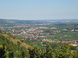
San Pietro in Cariano
Comune in Veneto, Italy From Wikipedia, the free encyclopedia
San Pietro in Cariano (Venetian: San Piero in Carian) is a comune (municipality) in the Province of Verona in the Italian region Veneto, located about 110 kilometres (68 mi) west of Venice and about 12 kilometres (7 mi) northwest of Verona. It is located in the geographical region of Valpolicella.
San Pietro in Cariano
San Piero in Carian | |
|---|---|
| Comune di San Pietro in Cariano | |
 | |
| Coordinates: 45°31′N 10°53′E | |
| Country | Italy |
| Region | Veneto |
| Province | Verona (VR) |
| Frazioni | Bure, Castelrotto, Corrubbio, Pedemonte, San Floriano, |
| Government | |
| • Mayor | Giorgio Accordini |
| Area | |
• Total | 20.25 km2 (7.82 sq mi) |
| Elevation | 151 m (495 ft) |
| Population (1 June 2007)[2] | |
• Total | 12,863 |
| • Density | 640/km2 (1,600/sq mi) |
| Demonym | Carianesi |
| Time zone | UTC+1 (CET) |
| • Summer (DST) | UTC+2 (CEST) |
| Postal code | 37029 |
| Dialing code | 045 |
| Patron saint | St. Peter Apostle |
| Saint day | 29 June |
| Website | Official website |
The main attraction is the Romanesque pieve of San Floriano (10th century) and Villa Serego, a Palladian villa designed by Andrea Palladio.
Twin towns
San Pietro in Cariano is twinned with:[3]
 Ingelheim am Rhein, Germany
 Ludlow, England, United Kingdom
 Stans, Austria
See also
References
External links
Wikiwand - on
Seamless Wikipedia browsing. On steroids.


