San Nicolas, Manila
District of Manila, Metro Manila, Philippines From Wikipedia, the free encyclopedia

San Nicolas is one of the sixteen districts in the city of Manila in the Philippines. It is located at the west central part of the city, on the northern bank of the Pasig River[2] bounded by the districts of Binondo to the east by Estero de Binondo, and Tondo to the north and west, and by the Pasig River to the south. Considered as a heritage district of Manila,[3] this community has kept its 19th-century ancestral houses, which symbolizes the wealthy lives of the people who used to live there, similar to the ancestral houses of Silay and Vigan.
San Nicolas | |
|---|---|
District of Manila | |
.jpg) View of the skyline of San Nicolas (left) and Binondo (right), taken from Fort Santiago, Manila | |
 | |
 | |
| Country | Philippines |
| Region | National Capital Region |
| City | Manila |
| Congressional district | Part of the 3rd district of Manila |
| Barangays | 15 |
| Founded | 1598 |
| Founded by | Dominican Order |
| Named after | Saint Nicholas |
| Area | |
• Total | 1.6385 km2 (0.6326 sq mi) |
| Population (2020)[1] | |
• Total | 42,957 |
| • Density | 26,000/km2 (68,000/sq mi) |
| Zip codes | 1010 |
| Area codes | 2 |
As of the May 1, 2020, national census, the population of San Nicolas, which is composed of 15 barangays named as numbers from 268 to 276 and from 281 to 286, is 42,957. This is slightly lower than the 2010 census that counted San Nicolas residents at 44,241.[1]
History
Summarize
Perspective
The town of San Nicolas was originally named Baybay, meaning "shore" in Tagalog.[3][4]
According to Piet Van der Loon (1966), a Sangley Chinese community had already settled in Baybay near Tondo on the banks of the Pasig river, before the Spanish conquest of Manila in the Battle of Manila (1570), and way before the market at Parián (modern-day Arroceros Urban Forest Park) attracted large numbers of traders and craftsmen, especially immigrants and merchants from Southern Fujian,[5] so before Parián and Binondo became the local Chinatown of the area, Sangley Chinese settlers and merchants were already living in Baybay in between Tondo and old Manila (modern-day Intramuros) on the south bank of the Pasig river.
During Spanish rule, Baybay was renamed to San Nicolas, after the patron saint of sailors, boatmen, and mariners.[6] San Nicolas is now the western part of Manila Chinatown, the first Chinatown in the Philippines, and perhaps the world;[7] the eastern part is Binondo, which was founded in 1594 by Governor-General Luis Pérez Dasmariñas.[7] The Dominican order came to western part of Chinatown in 1596[7] and then founded San Nicolas in 1598.[3] This was the first mission by the Dominicans outside Intramuros.[3]
In 1901, during the American Occupation of the Philippines, San Nicolas became a district of the newly chartered city of Manila as its borders were extended outside the walled city presently known as Intramuros.[8] Daniel Burnham, an American architect and urban planner, was commissioned to build a Plan of Manila.[9] The result of the plan was the making of places and parishes that included San Nicolas.[10] In modern times, San Nicolas is one of the administrative districts of Manila and part of the third legislative district of Manila.[11] It became an extension of the Filipino-Chinese community in Binondo.[12]
Barangays
| Barangay | Land area (km²) | Population (2020 census) |
|---|---|---|
| Zone 25 | ||
| Barangay 268 | 0.04373 | 489 |
| Barangay 269 | 0.04217 | 904 |
| Barangay 270 | 0.03705 | 918 |
| Barangay 271 | 0.06139 | 633 |
| Barangay 272 | 0.01970 | 1,064 |
| Barangay 273 | 0.02041 | 825 |
| Barangay 274 | 0.01210 | 1,944 |
| Barangay 275 | 0.02696 | 19,809 |
| Barangay 276 | 0.02080 | 2,543 |
| Zone 26 | ||
| Barangay 281 | 0.09284 | 2,288 |
| Barangay 282 | 0.1113 | 2,458 |
| Barangay 283 | 0.05035 | 1,345 |
| Barangay 284 | 0.05324 | 961 |
| Barangay 285 | 0.05489 | 2,066 |
| Barangay 286 | 0.04595 | 4,710 |
Barangays 268, 269, 270, 271, 272, 273, 274, 275, and 276 are part of Zone 25; and Barangays 281, 282, 283, 284, 285, and 286 are part of Zone 26.
List of cultural properties of San Nicolas
| Cultural Property wmph identifier[i] |
Site name | Description | Province | City or municipality |
Address | Coordinates | Image |
|---|---|---|---|---|---|---|---|
| Pasig River Lighthouse | Pasig River Lighthouse | Metro Manila | San Nicolas, Manila | Muelle dela Industria Street | 14°35′47″N 120°57′39″E |  Upload Photo | |
| General Antonio Luna Ancestral House | General Antonio Luna Ancestral House | Metro Manila | San Nicolas, Manila | #457 Urbiztondo Street | 14°35′54″N 120°58′20″E | Upload Photo | |
| Ides O'Racca Building | Ides O'Racca Building | Metro Manila | San Nicolas, Manila | M. De Santos St. | 14°35′54″N 120°58′20″E | Upload Photo |
In art
- Barrio de San Nicolas—Calle de Ylang-Ylang, watercolor by José Honorato Lozano, n.d.
Gallery
 Ancestral house
 Ancestral house
 Ancestral house
 Ancestral house
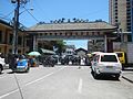 Arch of Solidarity
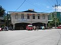 Fire Station
 Jose Abad Santos High School
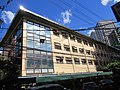 Justice Jose Abad Santos General Hospital
.jpg)
.jpg)
.jpg)
.jpg)


Notable
See also
Notes
- wmph is an internal identifier used by Wikimedia Philippines to identify the monument. This is not an official identifier, and only shown temporarily in the templates until the government creates an updated complete list.
References
Sources
Wikiwand - on
Seamless Wikipedia browsing. On steroids.