Samarinda
City and capital of East Kalimantan, Indonesia From Wikipedia, the free encyclopedia
Samarinda is the capital city of the Indonesian province of East Kalimantan on the island of Borneo. The city lies on the banks of the Mahakam River with a land area of 718 km2 (277 sq mi). Samarinda was one of Indonesia's top ten Most Liveable Cities in 2022,[12][13] ranks first on East Kalimantan Human Development Index[14] and it is the most populous city on the entire Borneo island, with a population of 727,500 at the 2010 Census[15] and 827,994 at the 2020 Census;[16] the official estimate as at mid 2023 was 868,499.[7] Samarinda is East Kalimantan's largest exporter[17] and fifth-largest importer.[18] The city has the highest number of bank headquarters in East Kalimantan.[19]
You can help expand this article with text translated from the corresponding article in Indonesian. (October 2023) Click [show] for important translation instructions.
|
Samarinda | |
|---|---|
| City of Samarinda Kota Samarinda | |
      | |
 Flag  Coat of arms | |
| Motto: Samarinda Kota Tepian | |
| Anthem: "March of Kota Tepian" | |
 Location within East Kalimantan | |
 Samarinda Location in Borneo | |
| Coordinates: 0°30′00″S 117°08′16″E | |
| Country | Indonesia |
| Region | Kalimantan |
| Province | East Kalimantan |
| Founded | 1668 |
| Government | |
| • Mayor | Andi Harun (Gerindra) |
| • Vice Mayor | Saefuddin Zuhri |
| • Legislative President | Helmi Abdullah |
| • Chief Justice | Didit Pambudi Widodo |
| Area | |
| 718 km2 (277 sq mi) | |
| • Land | 691.53 km2 (267.00 sq mi) |
| • Water | 26.47 km2 (10.22 sq mi) 3.65% |
| • Rank | 7th (Indonesia)[2] |
| Highest elevation | 260 m (850 ft) |
| Lowest elevation | 0 m (0 ft) |
| Population (mid 2024 estimate)[7] | |
| 868,499 | |
| • Rank | 1st (Borneo)[8] |
| • Density | 1,163/km2 (3,010/sq mi) |
| • Metro | 1,050,000 |
| Demonym | Samarindan[9] |
| Demographics | |
| • Religion[10] | Islam 91.93% Protestantism 5.25% Catholic 2.12% Buddhism 0.86% Hinduism 0.12% Confucianism 0.08% Others 0.01% |
| Time zone | UTC+08:00 (WITA) |
| Area code | +62541 |
| Administrative centre | Bugis[11] |
| Largest district by population | Sungai Kunjang[1] |
| Date format | dd-mm-yyyy |
| Drives on the | left |
| HDI (2022) | 0.814 (very high) |
In 2021, Samarinda Harbour became the busiest passenger port in East Kalimantan.[20] The container port in Samarinda is also the busiest in East Kalimantan, handled more than 271 thousand twenty-foot equivalent units (TEU) in 2019.[21][22]
Samarinda is known for its traditional food amplang, as well as the cloth sarung samarinda.[23] As of 2021, the city has 3 bridges connecting its river banks: Mahakam Bridge, Mahakam Ulu Bridge, and Achmad Amins Bridge. The city center is on one side and the other side is named Samarinda Seberang.
Etymology
The name Samarinda originates from the description of the way in which the Bugis houses were constructed. At that time houses were customarily built on a raft and generally had the same height. This provided important social symbolism of equality between residents; no person's house, and thus no person, was seen as higher or lower than another. They named the settlement “Samarenda”, meaning “equally low”. After hundreds of years of use the pronunciation of the name changed slightly and the city became known as Samarinda.[24]
History
Summarize
Perspective
At the start of the Gowa War, the Dutch under Admiral Speelman's command attacked Makassar from the sea. Meanwhile, the Netherlands' Bugis ally Arung Palakka led a ground attack. The Kingdom of Gowa was forced to surrender and Sultan Hasanuddin was made to sign the Treaty of Bongaja on 19 November 1667.[25]
The treaty did not quell all trouble for the Dutch however, since the Bugis from Gowa continued their struggle using guerilla tactics.[citation needed] Some Buginese moved to other islands close by such as Kalimantan. A few thousand people led by Lamohang Daeng Mangkona or Pua Ado I, moved to East Kalimantan, known then as Kutai, where they were welcomed by the local Sultan.[citation needed]
Samarinda was a small, sleepy town in 1942 with several small oil fields in the vicinity. It was occupied by the Japanese after the Dutch East Indies had fallen.[26]
In 1955, the Apostolic Vicariate of Samarinda was established in the city. In 1961, it was promoted as the Diocese of Samarinda. In 2003, the diocese was promoted as the Metropolitan Archdiocese of Samarinda.[25]
During its early days after formation in 1960, Samarinda originally only consisted of 2 districts, namely Samarinda Kota (not to be confused with the current district) and Samarinda Seberang (with a total area of 167 km2). Then, Samarinda Kota was later split into Samarinda Ilir and Samarinda Ulu (date unknown). On 24 April 1969, districts Palaran, Sanga-Sanga, Muara Jawa and Samboja were transferred from Kutai Regency to Samarinda, therefore, its total area increased to around 2,727 km2.[27]
Administrative districts
Summarize
Perspective
At the time of the 2010 Census, Samarinda City was divided into six districts (Indonesian: kecamatan), but four additional districts were subsequently created by splitting of existing ones. The ten districts are tabulated below with their areas and their populations at the 2010 Census[15] and the 2020 Census,[16] together with the official estimates as at mid 2023.[28] The table also includes the number of administrative villages in each district (all classed as urban kelurahan) and their post codes.
| Kode Wilayah | Name of District (kecamatan) | Area in km2 | Pop'n Census 2010 | Pop'n Census 2020 | Pop'n Estimate mid 2023 | No. of kelurahan | Post codes |
|---|---|---|---|---|---|---|---|
| 64.72.01 | Palaran | 221.29 | 49,079 | 63,189 | 66,912 | 5 | 75241 - 75253 |
| 64.72.02 | Samarinda Seberang | 12.49 | 114,183 | 64,050 | 65,796 | 6 | 75131 - 75133 |
| 64.72.03 | Samarinda Ulu (Upper Samarinda) | 22.12 | 126,651 | 129,806 | 133,331 | 8 | 75122 - 75128 |
| 64.72.04 | Samarinda Ilir (Lower Samarinda) | 17.18 | 120,936 | 69,142 | 69,766 | 5 | 75114 - 75117 |
| 64.72.05 | North Samarinda (Samarinda Utara) | 229.52 | 202,607 | 106,743 | 112,076 | 8 | 75117 - 75119 |
| 64.72.06 | Sungai Kunjang (Kunjang River) | 43.04 | 114,044 | 133,543 | 139,320 | 7 | 75125 - 75127 |
| 64.72.07 | Sambutan | 100.95 | (a) | 57,941 | 62,429 | 5 | 75114, 75115 |
| 64.72.08 | Sungai Pinang (Pinang River) | 34.16 | (c) | 105,970 | 110,473 | 5 | 76117 - 76119 |
| 64.72.09 | Samarinda Kota (Samarinda town) | 11.12 | (a) | 31,719 | 32,379 | 5 | 7511 - 75113, 75117, 75121 |
| 64.72.10 | Loa Janan Ilir | 26.13 | (b) | 65,892 | 69,396 | 5 | 75131 |
| Totals | 718.00 | 727,500 | 827,994 | 861,878 | 59 |
Notes: (a) the 2010 populations of Samarinda Kota and Sambutan Districts are included in the 2010 figure for Samarinda Ilir District, from which they were later split off. (b) the 2010 population of Loa Janan Ilir District is included in the figure for Samarinda Seberang District, from which it was later split off. (c) the 2010 population of Sungai Pinang District is included in the figure for Samarinda Utara District, from which it was later split off.

Climate
Summarize
Perspective
Samarinda has a tropical rainforest climate (Köppen: Af) with heavy rainfall and hot, oppressively humid temperatures year-round. Hail is extremely rare, it was recorded on 21 November 2019.[29][30] The lowest recorded temperature in Samarinda is 18.0 °C (64.4 °F) in October 1982,[31] while the highest recorded is 40.2 °C (104 °F) on 8 February 2008.[32]
| Climate data for Samarinda (Temindung Airport) (1991–2020 normals, extremes 1993–2023) | |||||||||||||
|---|---|---|---|---|---|---|---|---|---|---|---|---|---|
| Month | Jan | Feb | Mar | Apr | May | Jun | Jul | Aug | Sep | Oct | Nov | Dec | Year |
| Record high °C (°F) | 35.6 (96.1) |
35.9 (96.6) |
36.6 (97.9) |
35.8 (96.4) |
35.8 (96.4) |
35.0 (95.0) |
35.6 (96.1) |
36.6 (97.9) |
36.4 (97.5) |
36.0 (96.8) |
35.8 (96.4) |
35.8 (96.4) |
36.6 (97.9) |
| Mean daily maximum °C (°F) | 32.3 (90.1) |
32.6 (90.7) |
32.8 (91.0) |
32.6 (90.7) |
32.4 (90.3) |
31.8 (89.2) |
31.6 (88.9) |
32.2 (90.0) |
32.5 (90.5) |
32.7 (90.9) |
32.5 (90.5) |
32.5 (90.5) |
32.4 (90.3) |
| Daily mean °C (°F) | 28.5 (83.3) |
28.4 (83.1) |
28.9 (84.0) |
28.5 (83.3) |
28.5 (83.3) |
28.0 (82.4) |
27.6 (81.7) |
27.9 (82.2) |
28.3 (82.9) |
28.8 (83.8) |
28.7 (83.7) |
28.5 (83.3) |
28.4 (83.1) |
| Mean daily minimum °C (°F) | 24.1 (75.4) |
24.2 (75.6) |
24.6 (76.3) |
24.2 (75.6) |
24.4 (75.9) |
24.1 (75.4) |
23.7 (74.7) |
23.6 (74.5) |
23.9 (75.0) |
24.5 (76.1) |
24.4 (75.9) |
24.1 (75.4) |
24.2 (75.5) |
| Record low °C (°F) | 20.4 (68.7) |
21.1 (70.0) |
21.6 (70.9) |
20.7 (69.3) |
21.4 (70.5) |
21.0 (69.8) |
19.6 (67.3) |
20.0 (68.0) |
20.2 (68.4) |
21.2 (70.2) |
19.0 (66.2) |
18.6 (65.5) |
18.6 (65.5) |
| Average precipitation mm (inches) | 166 (6.5) |
173 (6.8) |
202 (8.0) |
236 (9.3) |
181 (7.1) |
168 (6.6) |
160 (6.3) |
148 (5.8) |
118 (4.6) |
145 (5.7) |
196 (7.7) |
209 (8.2) |
2,102 (82.6) |
| Source 1: Starlings Roost Weather[33] | |||||||||||||
| Source 2: [34] | |||||||||||||
Demographics
Summarize
Perspective
The territory's population in mid 2023 was 861,876, with an annual growth rate of 1.43% in 2022–2023.[28] The majority of the people of Samarinda are of Native Indonesian and Chinese descent with a small minority of Arabs. There are also Americans, Canadians, Europeans, Japanese, Filipinos and Koreans working in Samarinda. Life expectancy in Samarinda was 73.6 years as of 2014.
Religion
Samarinda's main religions are Islam and Christianity. The Muslim community forms the majority of the population numbering around 91%. The Christian community numbers at nearly 66,000 individuals or slightly over 7% of the total population; Protestants form a larger number than Roman Catholics at a rate of 10:3. There are also small Buddhist, Hindu and other religious communities.[35]

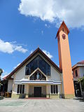 Cathedral of Saint Mary
 Muladharma Buddhist temple
 Thien Ie Kong temple


Economy
Summarize
Perspective

Since 2004, trade has been the engine of Samarinda's economic growth.[36] It is also driven by the large amount of logging and oil extraction companies based there. Similar to Balikpapan, many national logging companies are based in Samarinda.[citation needed] There are many abandoned coal mines in Samarinda. Coal mining used to be very popular in Samarinda. However, the Indonesian government revoked many mining licenses due to the use of illegal chemicals and machinery.[citation needed]
Tourism sector also plays an important role in Samarinda's economy; it attracted over 2,000 international tourists and 1.2 million domestic tourists in 2019,[37] making Samarinda the 2nd most popular tourists destination in East Kalimantan.[38] In 2020, agriculture constituted only 2 per cent of GDP, and consists of growing flower varieties (rose, jasmine, orchid) and fruits (pomelo citrus fruit).[14]

Commerce
Samarinda is home to several malls and traditional markets. Among them include Samarinda Morning Market, Segiri Market, Samarinda Central Plaza, Mal Lembuswana, and Big Mall Samarinda.
Transport
Summarize
Perspective


The main transport infrastructure of Samarinda is different than every other cities in Kalimantan, characterised by less national government involvement: Samarinda International Airport (East Kalimantan government),[39][40] SkyTrain rapid transit project (public-private partnership),[41][42] Samarinda Tunnel project (Samarinda Government)[43][44] and Port of Palaran (private).[45]
There are about 850,000 vehicles registered in Samarinda, the highest number of vehicles of any city in East Kalimantan.[46] Samarinda has 3 bus terminals: Sungai Kunjang Bus Terminus, Lempake Bus Terminus and Seberang Bus Terminus.[47]
Samarinda is connected by Trans-Kalimantan Highway Southern Route from Balikpapan to Samarinda; the highway runs in parallel with the first controlled-access expressway in Borneo, the Samarinda-Balikpapan Expressway, which is now under construction, and expected to be operational by the end of 2018.[48]
APT Pranoto (Samarinda Sungai Siring, AAP) International Airport is the primary airport for the city and has been at Sungai Siring since 2018. With over 1 million passengers annually, it is one of East Kalimantan's busiest airports in terms of passenger and cargo movements. AAP is an important Australian passenger gateway for East Kalimantan's wildlife. AAP was built to replace Temindung Airport in Bandara, Sungai Pinang.
The prominent coal loading port of Tanjung Bara (TBCT) lies about 160 kilometres to the north of Samarinda.[49]
Notable people
References
External links
Wikiwand - on
Seamless Wikipedia browsing. On steroids.