Salto Abajo
Barrio of Utuado, Puerto Rico From Wikipedia, the free encyclopedia

Salto Abajo is a barrio in the municipality of Utuado, Puerto Rico. Its population in 2010 was 3,929.[3][4][5]
Salto Abajo | |
|---|---|
Barrio | |
 Puerto Rico Highway 10 in Salto Abajo | |
 Location of Salto Abajo within the municipality of Utuado shown in red | |
 Salto Abajo Location of Puerto Rico | |
| Coordinates: 18°17′12″N 66°42′37″W[1] | |
| Commonwealth | Puerto Rico |
| Municipality | Utuado |
| Area | |
• Total | 2.66 sq mi (6.9 km2) |
| • Land | 2.63 sq mi (6.8 km2) |
| • Water | 0.03 sq mi (0.08 km2) |
| Elevation | 568 ft (173 m) |
| Population (2010) | |
• Total | 3,929 |
| • Density | 1,493.9/sq mi (576.8/km2) |
| Source: 2010 Census | |
| Time zone | UTC−4 (AST) |
Geography
Salto Abajo is situated at an elevation of 568 feet (173 m), just north of Salto Arriba and Pueblo in Utuado, Puerto Rico. It has an area of 2.66 square miles (6.9 km2) of which 0.03 square miles (0.078 km2) is water.[1]
History
Salto Abajo was in Spain's gazetteers[6] until Puerto Rico was ceded by Spain in the aftermath of the Spanish–American War under the terms of the Treaty of Paris of 1898 and became an unincorporated territory of the United States. In 1899, the United States Department of War conducted a census of Puerto Rico finding that the population of Salto Abajo barrio was 836.[7]
Features
After the rope bridge in Salto Abajo was destroyed by Hurricane Maria in 2017, engineering students from the University of New Mexico and University of Texas at El Paso began its reconstruction, but never completed the work.[13]
Gallery
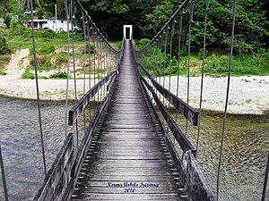 Puente La Hamaca in Salto Abajo, 2010
 Puerto Rico Highway 111 in Salto Abajo


See also
References
Wikiwand - on
Seamless Wikipedia browsing. On steroids.