Sainte-Honorine-la-Chardonne
Commune in Normandy, France From Wikipedia, the free encyclopedia
Sainte-Honorine-la-Chardonne is a commune in the Orne department in north-western France.[3]
Sainte-Honorine-la-Chardonne | |
|---|---|
 The town hall in Sainte-Honorine-la-Chardonne | |
Location of Sainte-Honorine-la-Chardonne  | |
 Sainte-Honorine-la-Chardonne  Sainte-Honorine-la-Chardonne | |
| Coordinates: 48°49′29″N 0°29′04″W | |
| Country | France |
| Region | Normandy |
| Department | Orne |
| Arrondissement | Argentan |
| Canton | Athis-Val de Rouvre |
| Intercommunality | CA Flers Agglo |
| Government | |
| • Mayor (2020–2026) | Emmanuel Le Secq[1] |
Area 1 | 14.4 km2 (5.6 sq mi) |
| Population (2022)[2] | 681 |
| • Density | 47/km2 (120/sq mi) |
| Time zone | UTC+01:00 (CET) |
| • Summer (DST) | UTC+02:00 (CEST) |
| INSEE/Postal code | 61407 /61430 |
| Elevation | 78–251 m (256–823 ft) (avg. 235 m or 771 ft) |
| 1 French Land Register data, which excludes lakes, ponds, glaciers > 1 km2 (0.386 sq mi or 247 acres) and river estuaries. | |
Geography
The commune is part of the area known as Suisse Normande.[4]
The commune is made up of the following collection of villages and hamlets, La Barbotière,Cingal, La Pouplière, Les Petits Champs,La Soubinière,La Ferté, Le Châtellier, La Forgé Martin, La Rivière, La Pérée, La Bernottière, La Grésillière, Laubenière and Sainte-Honorine-la-Chardonne.[5]
The only watercourse to run through the commune is a River, La Vere.
Notable buildings and places
Renaissance Garden of Sainte-Honorine-la-Chardonne is a 5000m2 garden built around the ruins of the Manoir de la Boisnerie and is open to the public.[7] The garden is classed as a Jardins remarquables by the Ministry of Culture and the Comité des Parcs et Jardins de France.[8]
National heritage sites
Château de Saint-Sauveur is a 16th Century Chateau that was classed as a Monument historique in 2009.[9]
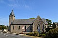 Sainte-Honorine Church in Sainte-Honorine-la-Chardonne
 Saint Honorine Church


Notable People
- Guy Lefèvre de la Boderie a 16th century French Orientalist, Bible scholar and poet was born here.[10]
- Guillaume Martin is a French professional cyclist who has competed in all 3 Grand tours, winning the Mountains classification in the Vuelta a España grew up here as a child and continues to have a presence here.[11][12][13]
See also
References
Wikiwand - on
Seamless Wikipedia browsing. On steroids.