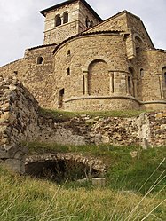
Saint-Romain-le-Puy
Commune in Auvergne-Rhône-Alpes, France From Wikipedia, the free encyclopedia
Commune in Auvergne-Rhône-Alpes, France From Wikipedia, the free encyclopedia
Saint-Romain-le-Puy (French pronunciation: [sɛ̃ ʁɔmɛ̃ lə pɥi]) is a commune in the Loire department in central France.[3]
Saint-Romain-le-Puy | |
|---|---|
Commune | |
 Priory church | |
| Coordinates: 45°33′22″N 4°07′26″E | |
| Country | France |
| Region | Auvergne-Rhône-Alpes |
| Department | Loire |
| Arrondissement | Montbrison |
| Canton | Montbrison |
| Intercommunality | Loire Forez Agglomération |
| Government | |
| • Mayor (2024–2026) | Christian Soulier[1] |
| Area 1 | 21.14 km2 (8.16 sq mi) |
| Population (2021)[2] | 4,108 |
| • Density | 190/km2 (500/sq mi) |
| Time zone | UTC+01:00 (CET) |
| • Summer (DST) | UTC+02:00 (CEST) |
| INSEE/Postal code | 42285 /42610 |
| Elevation | 366–524 m (1,201–1,719 ft) (avg. 407 m or 1,335 ft) |
| 1 French Land Register data, which excludes lakes, ponds, glaciers > 1 km2 (0.386 sq mi or 247 acres) and river estuaries. | |
The town is located 8 km (5.0 mi) from Montbrison along the D8. It was originally built on the volcanic peak (le puy), but has since migrated to the plain.
Le Puy itself is of volcanic origin and the surrounding plain of Forez has basaltic conglomerates. Wells have been sunk to exploit the naturally sparkling mineral waters.
Le Puy is located on the Roman road, the Bolène Way, linking Lyon (Lugdunum) to Bordeaux (Burdigala), which was constructed during the reign of the emperor Augustus, by his son-in-law Agrippa. It is also on the Gallo-Roman way from Sury to Changy. These roads were later reused by pilgrims to Santiago de Compostela.
About 500, Carétène (aunt of Saint Clotilde the wife of Clovis) replaced a temple of Venus (famous for a bath of youth utilising the areas' mineral springs) by a Christian church dedicated to Saint Michael.
Guy II de Forez, the feudal lord of Saint-Romain-le-Puy, was the vassal of Louis VII. In 1173, the fief of Saint-Romain was transferred from Ainay Abbey to the County of Lyon.
In 1218, Count Guy IV de Forez, gave the priory (founded in 1007) into the care of the religious of Saint-Thomas-les-Nonnains.
There was longstanding conflict between the chateau and the priory.
In 1431, the town was pillaged by routiers under Rodrigo de Villandrando on orders from the Crown as part of the quashing of a jacquerie.
In 1531, Forez passed from the control of the Dukes of Bourbon to the Crown of France.
In 1633, the surrounding town wall was destroyed by order of Richelieu.
During World War I, the town lost 102 soldiers.
| Year | Pop. | ±% p.a. |
|---|---|---|
| 1968 | 2,459 | — |
| 1975 | 2,475 | +0.09% |
| 1982 | 2,423 | −0.30% |
| 1990 | 2,616 | +0.96% |
| 1999 | 2,803 | +0.77% |
| 2007 | 3,419 | +2.51% |
| 2012 | 3,746 | +1.84% |
| 2017 | 3,998 | +1.31% |
| Source: INSEE[4] | ||
Local industries include Mineral Waters (François Parot, a public works entrepreneur sunk a well in 1858) and Glassmaking (Saint-Gobain-Emballage factory founded in 1893). Agriculture includes beef rearing, dairying and wine-growing.
The commune is twinned with Monte San Biagio (Italy).
Seamless Wikipedia browsing. On steroids.
Every time you click a link to Wikipedia, Wiktionary or Wikiquote in your browser's search results, it will show the modern Wikiwand interface.
Wikiwand extension is a five stars, simple, with minimum permission required to keep your browsing private, safe and transparent.