Rural Municipality of Fertile Valley No. 285
Rural municipality in Saskatchewan, Canada From Wikipedia, the free encyclopedia
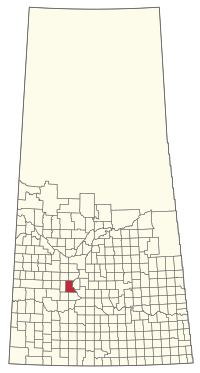
The Rural Municipality of Fertile Valley No. 285 (2016 population: 539) is a rural municipality (RM) in the Canadian province of Saskatchewan within Census Division No. 12 and SARM Division No. 5. It is located in the southwest portion of the province.
Fertile Valley No. 285 | |
|---|---|
| Rural Municipality of Fertile Valley No. 285 | |
 Location of the RM of Fertile Valley No. 285 in Saskatchewan | |
| Coordinates: 51.401°N 107.080°W[1] | |
| Country | Canada |
| Province | Saskatchewan |
| Census division | 12 |
| SARM division | 5 |
| Formed[2] | December 13, 1909 |
| Government | |
| • Reeve | Barry Friesen |
| • Governing body | RM of Fertile Valley No. 285 Council |
| • Administrator | L Jean Jones |
| • Office location | Conquest |
| Area (2016)[4] | |
| • Land | 1,016.37 km2 (392.42 sq mi) |
| Population (2016)[4] | |
| • Total | 539 |
| • Density | 0.5/km2 (1/sq mi) |
| Time zone | CST |
| • Summer (DST) | CST |
| Postal code | S0L 0L0 |
| Area code(s) | 306 and 639 |
| Highway(s) | Highway 15 Highway 44 Highway 45 |
| Waterway(s) | Anerley Lakes Coteau Lake Macdonald Creek Milden Lake South Saskatchewan River Stockwell Lake |
History
The RM of Fertile Valley No. 285 incorporated as a rural municipality on December 13, 1909.[2]
Geography
Communities and localities
The following urban municipalities are surrounded by the RM.
The following unincorporated communities are within the RM.
- Localities
Attractions
The eastern boundary of the RM runs along the South Saskatchewan River with the south-east corner at Gardiner Dam on Lake Diefenbaker. A portion of Danielson Provincial Park is within the RM near the dam.
On the RM's eastern boundary, and the western bank of the South Saskatchewan River, is Coldwell Park Recreation Site (51.3098°N 106.9353°W).[5] It is a provincial recreation site that has a day-use area, access to the river, a picnic site, and 19 rustic campsites.[6] Access is off Highway 44.[7][8]
Demographics
In the 2021 Census of Population conducted by Statistics Canada, the RM of Fertile Valley No. 285 had a population of 604 living in 169 of its 181 total private dwellings, a change of 12.1% from its 2016 population of 539. With a land area of 1,010.19 km2 (390.04 sq mi), it had a population density of 0.6/km2 (1.5/sq mi) in 2021.[11]
In the 2016 Census of Population, the RM of Fertile Valley No. 285 recorded a population of 539 living in 170 of its 182 total private dwellings, a 5.5% change from its 2011 population of 511. With a land area of 1,016.37 km2 (392.42 sq mi), it had a population density of 0.5/km2 (1.4/sq mi) in 2016.[4]
Government
The RM of Fertile Valley No. 285 is governed by an elected municipal council and an appointed administrator that meets on the second Wednesday of every month.[3] The reeve of the RM is Barry Friesen while its administrator is L Jean Jones.[3] The RM's office is located in Conquest.[3]
Transportation
| Highway | Starting point | Community | Ending point |
|---|---|---|---|
| Highway 15 | Highway 4 | None | Highway 20 |
| Highway 44 | Highway 9 | Macrorie | Highway 11 |
| Highway 45 | Highway 7 | Macrorie | Highway 42 |
See also
References
Wikiwand in your browser!
Seamless Wikipedia browsing. On steroids.
Every time you click a link to Wikipedia, Wiktionary or Wikiquote in your browser's search results, it will show the modern Wikiwand interface.
Wikiwand extension is a five stars, simple, with minimum permission required to keep your browsing private, safe and transparent.

