Top Qs
Timeline
Chat
Perspective
River Sett
River in Derbyshire, England From Wikipedia, the free encyclopedia
Remove ads
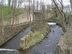
The River Sett is a river that flows through the High Peak borough of Derbyshire, in north western England. It rises near Edale Cross on Kinder Scout and flows through the villages of Hayfield and Birch Vale to join the River Goyt at New Mills.[1] The River Goyt is one of the principal tributaries of the River Mersey. In the past, the river was known as the River Kinder; the modern River Kinder is a right tributary of the Sett, joining the river at Bowden Bridge above Hayfield.[2]

The 2.5-mile Sett Valley Trail follows the trackbed of the former railway line along the valley between Hayfield and New Mills.[3]
The river's Environment Agency pollution classification changed from good to moderate in 2014.[4]
Remove ads
Tributaries
- Dimpus Clough (L)
- Coldwell Clough (R)
- Tunstead Clough (R)
- Hydebank Brook ? (L)
- Thornsett/Rowarth Brook ? (R)
- Gibb Brook ? (L)
- Raens Brook (L)
- Birch Hall Brook ? (L)
- Hollingworth Clough ? (R)
- Middle Brook ? (L)
- Phoside Brook ? (L)
- Foxholes Clough (L)
- Hazlehurst Brook (L)
- River Kinder (R)
- Upper Brook ? (L)
- William Clough ? (R)
- Blackshaws Brook ? (L)
- Red Brook (L)
- Oaken Clough (R)
Remove ads
See also
References
Wikiwand - on
Seamless Wikipedia browsing. On steroids.
Remove ads


