Rehfelde
Municipality in Brandenburg, Germany From Wikipedia, the free encyclopedia

Rehfelde is a municipality in the district Märkisch-Oderland, in Brandenburg, Germany.
Rehfelde | |
|---|---|
 Church in Rehfelde village | |
 Coat of arms | |
Location of Rehfelde
within Märkisch-Oderland district  | |
 Rehfelde  Rehfelde | |
| Coordinates: 52°31′12″N 13°55′45″E | |
| Country | Germany |
| State | Brandenburg |
| District | Märkisch-Oderland |
| Municipal assoc. | Märkische Schweiz |
| Subdivisions | 3 Ortsteile |
| Government | |
| • Mayor (2024–29) | Patrick Gumpricht[1] |
| Area | |
• Total | 46.15 km2 (17.82 sq mi) |
| Elevation | 55 m (180 ft) |
| Population (2022-12-31)[2] | |
• Total | 5,334 |
| • Density | 120/km2 (300/sq mi) |
| Time zone | UTC+01:00 (CET) |
| • Summer (DST) | UTC+02:00 (CEST) |
| Postal codes | 15345 |
| Dialling codes | 033435 |
| Vehicle registration | MOL |
History
With the foundation of a plywood mill in 1906, the first manufacturing company came to Rehfelde. On September 3, 1907 the night the express train from Insterburg to Berlin derailed at a speed of about 85 km/h near Rehfelde station. On July 12, 1908 set up twelve citizens a volunteer fire department. In the early 20th century, the population rose sharply. This was due to rising rents in Berlin, which led to an increased influx. During World War I 24 community residents lost their lives. In 1922, the local branch of the Communist Party of Germany, five years later the Social Democratic Party were founded. In the period of National Socialism, some citizens of the municipality resisted the Nazis, including the communist Wilhelm Betke and the pastor Otto Perel. During World War II several houses were destroyed by bombing in the year 1944. Around 100 people lost their lives due to the war.
After the war
During the land reforms in the years 1945 to 1949, the government distributed about 1,000 hectares of land to settlers and farmers. On 20 February 1953, the Landwirtschaftliche Produktionsgenossenschaft Friedrich Ebert was founded. A daycare center was opened on January 10, 1984, a youth club on October 7, 1989.[3][4]
Demography
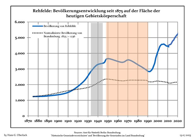
|
|
References
External links
Wikiwand - on
Seamless Wikipedia browsing. On steroids.