Rebun Island
Island in the Sea of Japan From Wikipedia, the free encyclopedia

Rebun Island (礼文島, Rebun-tō, Ainu: Repun) is an island in the Sea of Japan off the northwestern tip of Hokkaidō, Japan. The island sits 50 kilometres (31 mi) off the coast of Hokkaidō. Rebun stretches 29 kilometres (18 mi) from north to south and 8 kilometres (5.0 mi) from east to west. The island covers approximately 80 square kilometres (31 sq mi). Rebun Island is located 10 kilometres (6.2 mi) northwest of Rishiri Island, and the two islands are separated by the Rebun Channel.[1][2][3]
Native name: 礼文島, Rebun-tō | |
|---|---|
| |
 Rebun | |
| Geography | |
| Location | East Asia |
| Coordinates | 45°22′07″N 141°00′55″E |
| Archipelago | Japanese Archipelago |
| Area | 80 km2 (31 sq mi) |
| Length | 29 km (18 mi) |
| Width | 8 km (5 mi) |
| Coastline | 72 km (44.7 mi) |
| Highest elevation | 490.0 m (1607.6 ft) |
| Highest point | Mount Rebun |
| Administration | |
| Prefecture | Hokkaido |
| Subprefecture | Sōya Subprefecture |
| District | Rebun District |
| Town | Rebun |
| Demographics | |
| Population | 3,194 (2007-12-31) |
| Pop. density | 39.3/km2 (101.8/sq mi) |
| Ethnic groups | Ainu, Japanese |

Rebun Island is known for its alpine flowers and the 8-Hour Hiking Course which runs from one end of the island to the other, north to south. The hiking course can be broken into two sections, known as the 4-Hour Hiking Courses. Rebun Island is home to a chashi, or hilltop fortification of the Ainu people. The highest point on the island is Mount Rebun (490 metres (1,610 ft)).[2] The island is part of the Rishiri-Rebun-Sarobetsu National Park.
Fossilized remains of long-finned pilot whales that are now extinct in the north Pacific have been excavated on Rebun Island, [4] and remains of funerals for orcas, possibly referring them as Repun Kamuy (God of Sea/Offshore) have been found as well.[5] Rebun Island is also the site where the last reliable record of the extinct Japanese sea lion came from in 1974.
Etymology
The name of the island comes from the Ainu language, in which "Repun" means "(island) in the open sea" (from rep "the offing, open sea" + -un "to be in ~").[1][2]
Climate
| Climate data for Rebun, 2003–2020 normals, extremes 2004–present | |||||||||||||
|---|---|---|---|---|---|---|---|---|---|---|---|---|---|
| Month | Jan | Feb | Mar | Apr | May | Jun | Jul | Aug | Sep | Oct | Nov | Dec | Year |
| Record high °C (°F) | 6.9 (44.4) |
6.7 (44.1) |
11.0 (51.8) |
17.4 (63.3) |
20.8 (69.4) |
24.6 (76.3) |
29.9 (85.8) |
30.5 (86.9) |
29.0 (84.2) |
22.3 (72.1) |
15.5 (59.9) |
10.9 (51.6) |
30.5 (86.9) |
| Mean daily maximum °C (°F) | −2.7 (27.1) |
−2.1 (28.2) |
1.7 (35.1) |
6.6 (43.9) |
11.6 (52.9) |
15.9 (60.6) |
20.4 (68.7) |
22.6 (72.7) |
20.5 (68.9) |
13.9 (57.0) |
6.1 (43.0) |
−0.3 (31.5) |
9.5 (49.1) |
| Daily mean °C (°F) | −4.6 (23.7) |
−4.3 (24.3) |
−0.4 (31.3) |
4.1 (39.4) |
8.5 (47.3) |
12.8 (55.0) |
17.3 (63.1) |
19.7 (67.5) |
17.4 (63.3) |
11.2 (52.2) |
3.6 (38.5) |
−2.4 (27.7) |
6.9 (44.4) |
| Mean daily minimum °C (°F) | −6.5 (20.3) |
−6.4 (20.5) |
−2.4 (27.7) |
1.8 (35.2) |
6.0 (42.8) |
10.3 (50.5) |
14.9 (58.8) |
17.3 (63.1) |
14.5 (58.1) |
8.4 (47.1) |
1.2 (34.2) |
−4.5 (23.9) |
4.6 (40.2) |
| Record low °C (°F) | −15.8 (3.6) |
−17.1 (1.2) |
−9.6 (14.7) |
−5.7 (21.7) |
0.2 (32.4) |
4.0 (39.2) |
8.1 (46.6) |
10.9 (51.6) |
5.8 (42.4) |
−1.1 (30.0) |
−11.4 (11.5) |
−13.4 (7.9) |
−17.1 (1.2) |
| Average precipitation mm (inches) | 73.4 (2.89) |
51.6 (2.03) |
44.1 (1.74) |
49.2 (1.94) |
79.7 (3.14) |
84.6 (3.33) |
101.0 (3.98) |
138.6 (5.46) |
131.1 (5.16) |
100.4 (3.95) |
98.4 (3.87) |
91.5 (3.60) |
1,043.6 (41.09) |
| Average precipitation days (≥ 1.0 mm) | 17.9 | 14.4 | 10.9 | 8.7 | 9.7 | 9.6 | 7.5 | 8.9 | 10.5 | 11.6 | 12.9 | 16.2 | 138.8 |
| Mean monthly sunshine hours | 47.5 | 72.2 | 153.8 | 192.7 | 170.4 | 125.9 | 126.5 | 154.2 | 186.7 | 159.6 | 82.0 | 42.5 | 1,514.3 |
| Source 1: JMA[6] | |||||||||||||
| Source 2: JMA[7] | |||||||||||||
Areas of interest
- Mount Rebun
- Peach Rock, or Momoiwa
- Jizo Rock
- Cat Rock, or Nekoiwa
- Cape Sukoton
- Cape Kaneda
- Cape Gorota
- Cape Sukai
- Todo Island
- Lake Kushu
- Yamunai Valley
- Rebun Forest Road
- Rebun Falls
Communities
All communities on Rebun Island are part of the town of Rebun in Rebun District. From roughly from north to south, they are:[8]
- Sukoton
- Awabikoton
- Hamanaka
- Funadomari
- Horodomari
- Uedomari
- Nairo
- Kitousu
- Kafukai
- Kafuka
- Shiretoko
Transportation
- Ferry link to Rishiri Island and Wakkanai
- Air link to Wakkanai Airport
Ancient people
A Jōmon woman excavated from Funadomari remains (about 3,800 – 3,500 YBP) on the Rebun Island in Hokkaido belongs to Haplogroup D1b2a(D-CTS220).[9] This discovery proved the hypothesis that Haplogroup D1b is one of the Jomon lineages.
In popular culture
In the manga and anime series Food Wars!: Shokugeki no Soma, the island is the last step in the Promotion test which takes place across Hokkaido Island.
Gallery
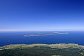 Rebun island (background) seen from Mount Rishiri
 Lake Kusyu on Rebun island
 Neko-iwa, 'cat rock'
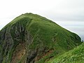 Momo-iwa, 'peach rock'
 Sukai Cape
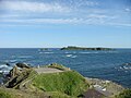 Sukoton Cape and Todo island
 Rebun Island in 2014


References
External links
Wikiwand - on
Seamless Wikipedia browsing. On steroids.