Razavi Khorasan province
Province of Iran From Wikipedia, the free encyclopedia
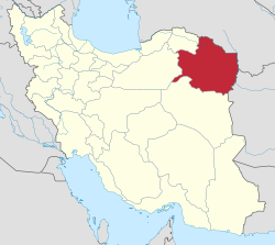
Razavi Khorasan province (Persian: استان خراسان رضوی)[a] is one of the 31 provinces of Iran, located in northeastern Iran. Its capital is the city of Mashhad, the second-most-populous city in Iran.[5]
Razavi Khorasan Province
Persian: استان خراسان رضوی | |
|---|---|
 Location of Khorasan-e Razavi province within Iran | |
| Coordinates: 35°47′N 58°42′E[1] | |
| Country | Iran |
| Region | Region 5 |
| Capital | Mashhad |
| Counties | 34 |
| Government | |
| • Governor-general | Gholam Hossein Mozaffari (Reformist) |
| Area | |
• Total | 118,884 km2 (45,901 sq mi) |
| Highest elevation | 3,211 m (10,535 ft) |
| Lowest elevation (Sarakhs) | 299 m (981 ft) |
| Population (2016)[2] | |
• Total | 6,434,501 |
• Estimate (2020) | 6,871,000[3] |
| • Density | 54/km2 (140/sq mi) |
| Demonym | Khorasani (Persian: خراسانی) |
| Time zone | UTC+03:30 (IRST) |
| Area code | 051 |
| ISO 3166 code | IR-09 |
| Main language(s) | Persian |
| HDI (2017) | 0.781[4] high · 19th |
| Website | http://ostandari.khorasan.ir/ |
Razavi Khorasan is one of the three provinces that were created after the division of Khorasan Province in 2004. In 2014, it was placed in Region 5[6] with Mashhad as the location of the region's secretariat.
History
Summarize
Perspective
The Greater Khorasan has witnessed the rise and fall of many dynasties and governments in its territory throughout history. Various tribes of the Arabs, Turks, Kurds and Turkmens brought changes to the region time and time again.[7]
Ancient geographers of Iran divided Iran ("Ērānshahr") into eight segments of which the most flourishing and largest was the territory of Greater Khorasan. Esfarayen, among other cities of the province, was one of the focal points for residence of the Aryan tribes after entering Iran.
The Parthian Empire was based near Merv in Khorasan for many years. During the Sassanid dynasty, the province was governed by a Spahbod (Lieutenant General) called "Padgošban" and four margraves, each commander of one of the four parts of the province.
Khorasan was divided into four parts during the Muslim conquest of Persia, each section being named after one of the four largest cities, Nishapur, Merv, Herat, and Balkh.
In the year 651, the army of the Rashidun Caliphate conquered Khorasan. The territory remained under the rule of the Abbasid Caliphate until 820, followed by the rule of the Iranian Tahirid dynasty until 873, and the Samanid dynasty in 900.
Khorasan was the largest province of Iran until it was divided into three provinces on 29 September 2004. The provinces approved by the parliament of Iran (on 18 May 2004) and the Council of Guardians (on 29 May 2004) were Khorasan-e Razavi, North Khorasan, and South Khorasan.
Demographics
Summarize
Perspective
Ethnicity
The major ethnic group in this region are Persians, there are other sizeable communities such as Khorasani Kurds, Khorasani Turks, Turkmens and Khorasani Baloch.[8]
Population
At the time of the 2006 National Census, the province's population was 5,515,980 in 1,426,187 households.[9] The following census in 2011 counted 5,994,402 people in 1,716,314 households.[10] The 2016 census measured the population of the province as 6,434,501 in 1,938,703 households.[2]
Administrative divisions
The population history and structural changes of Razavi Khorasan province's administrative divisions over three consecutive censuses are shown in the following table.
| Counties | 2006[9] | 2011[10] | 2016[2] |
|---|---|---|---|
| Bajestan[b] | — | 30,664 | 31,207 |
| Bakharz[c] | — | 53,582 | 54,615 |
| Bardaskan | 68,392 | 72,626 | 75,631 |
| Chenaran | 108,533 | 125,601 | 155,013 |
| Dargaz | 73,439 | 74,326 | 72,355 |
| Davarzan[d] | — | — | 21,911 |
| Fariman | 86,428 | 93,930 | 99,001 |
| Firuzeh[e] | — | 42,739 | 37,539 |
| Golbahar[f] | — | — | — |
| Gonabad | 106,158 | 80,783 | 88,753 |
| Joghatai[g] | — | 47,920 | 49,175 |
| Joveyn[g] | — | 54,139 | 54,488 |
| Kalat | 39,560 | 38,232 | 36,237 |
| Kashmar | 146,536 | 157,149 | 168,664 |
| Khaf | 108,964 | 121,859 | 138,972 |
| Khalilabad | 44,993 | 49,111 | 51,701 |
| Khoshab[h] | — | 37,914 | 37,181 |
| Kuhsorkh[i] | — | — | — |
| Mahvelat | 47,068 | 48,900 | 51,409 |
| Mashhad | 2,848,637 | 3,069,941 | 3,372,660 |
| Miyan Jolgeh[j] | — | — | — |
| Nishapur | 441,184 | 433,105 | 451,780 |
| Quchan | 179,613 | 179,714 | 174,495 |
| Roshtkhar | 57,247 | 60,632 | 60,689 |
| Sabzevar | 429,187 | 319,893 | 306,310 |
| Salehabad[k] | — | — | — |
| Sarakhs | 85,524 | 89,956 | 97,519 |
| Sheshtamad[l] | — | — | — |
| Taybad | 143,205 | 108,424 | 117,564 |
| Torbat-e Heydarieh | 261,917 | 210,390 | 224,626 |
| Torbat-e Jam | 239,395 | 262,712 | 267,671 |
| Torqabeh and Shandiz[m][n] | — | 58,483 | 69,640 |
| Zaveh[o] | — | 71,677 | 67,695 |
| Zeberkhan[p] | — | — | — |
| Total | 5,515,980 | 5,994,402 | 6,434,501 |
Cities


According to the 2016 census, 4,700,924 people (over 72% of the population of Razavi Khorasan province) live in the following cities:[2]
The following sorted table lists the most populous cities in Razavi Khorasan according to 2016 Census results announced by Statistical Center of Iran.[2] After Mashhad, Nishapur, Sabzevar, and Torbat-e Heydarieh are the most populous cities of the province.
| Rank | City | County | Population |
|---|---|---|---|
| 1 | Mashhad | Mashhad | 2,987,323 |
| 2 | Nishapur | Nishapur | 264,375 |
| 3 | Sabzevar | Sabzevar | 243,700 |
| 4 | Torbat-e Heydarieh | Torbat-e Heydarieh | 140,019 |
| 5 | Kashmar | Kashmar | 102,282 |
| 6 | Quchan | Quchan | 101,604 |
| 7 | Torbat-e Jam | Torbat-e Jam | 100,449 |
| 8 | Taybad | Taybad | 56,562 |
| 9 | Chenaran | Chenaran | 53,879 |
| 10 | Sarakhs | Sarakhs | 42,179 |
Archaeological sites

The main archeological sites discovered in this province include:
Kohandezh hills
Excavations conducted by an American team between 1935 and 1940 in Nishapur discovered museum-worthy objects, which were shared with the government of the Shah. The Metropolitan Museum of Art's publications[citation needed] document its own Nishapur ceramics from those excavations. For half a century after 1945 the site of Nishapur was ransacked to feed the international market demand for early Islamic works of art. Nowadays, the Kohandezh hills reveal the remains from those excavations.[citation needed]
Shadiyakh
Shadiyakh was an important palace in old Nishapur up to the 7th century, and became more important and populated after that. The palace was completely ruined in the 13th century. It was the home of notables such as Farid al-Din Attar, whose tomb is found in Shadiyakh.
Attractions
Summarize
Perspective

This province contains many historical and natural attractions, such as mineral water springs, small lakes, recreational areas, caves and protected regions, and various hiking areas.
Besides these, Khorasan encompasses numerous religious buildings and places of pilgrimage, including the shrine of Imam Reza, Goharshad mosque and many other mausoleums and Imamzadehs which attract visitors to this province.
The Cultural Heritage of Iran lists 1179 sites of historical and cultural significance in all three provinces of Khorasan.
Some of the popular attractions of Khorasan-e Razavi are:

Mashhad
- Imam Reza Shrine
- Goharshad Mosque
- Tomb of Nader Shah
- Tomb of Khajeh Rabie
- Tomb of Ferdowsi
- Haruniyeh Dome

Nishapur
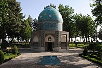
- Mausoleum of Attar of Nishapur
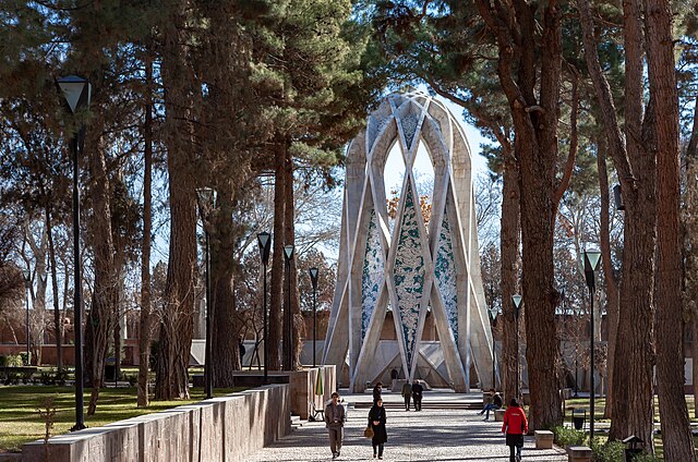
- Mausoleum of Omar Khayyám
- Tomb of Kamal-ol-molk
- Tomb of Heydar Yaghma
- Shadiyakh
- Jameh Mosque of Nishapur

Sabzevar
- Khosrogerd Minaret
- Pamenar Mosque, Sabzevar
- Jameh Mosque of Sabzevar
- Tomb of Hadi Sabzevari
- Tomb of Boghrat


Kashmar
- Arg of Kashmar
- Tomb of Hassan Modarres
- Imamzadeh Seyed Morteza
- Imamzadeh Hamzeh, Kashmar
- Imamzadeh Mohammad
- Grave of Pir Quzhd
- Jameh Mosque of Kashmar
- Haj Soltan Religious School
- Haji Jalal Mosque
- Atashgah Manmade-Cave
- Atashgah Castle
- Kohneh Castle, Zendeh Jan
- Rig Castle
- Amin al-tojar Caravansarai
- Talaabad Watermill
- Yakhchāl of Kashmar
Khalilabad
- Jameh Mosque of Khalilabad
- Kondor castle
- Kondor Ab anbars
Torbat-e Jam

Gonabad
- Forud castle
- Qanats of Gonabad
- Kūh-Zibad
Sarakhs


Bardaskan
- Tomb of Abdolabad
- Aliabad Tower
- Firuzabad Tower
- Firuzabad area
- Seyyed Bagher Ab anbar
- Darone Cave
- Sir Cave
- Rahmanniyeh Castle
- Qal'eh Dokhtar, Khooshab
- Qal'eh Dokhtar, Doruneh
Bajestan

Taybad
Rivash
Colleges and universities
- Asrar Institute of Higher Education[26]
- Bahar Institute of Higher Education[27]
- Comprehensive University of Applied and Practical Sciences, Khorasan[28]
- Ferdowsi University of Mashhad[29]
- Gonabad University of Medical Sciences[30]
- Hakim-e Sabzevari University of Sabzevar[31]
- Imam Reza University[32]
- Islamic Azad University of Bardaskan
- Islamic Azad University of Ghoochan
- Islamic Azad University of Gonabad[33]
- Islamic Azad University of Mashhad
- Islamic Azad University of Neishabur
- Islamic Azad University of Sabzevar[34]
- Islamic Azad University of Torbat e Jam
- Islamic Azad University of Torbat Heidariyeh
- Mashhad University of Medical Sciences
- Payame Noor University of Bardaskan
- Payame Noor University of Mashhad
- Sabzevar University of Medical Sciences[35]
- Sadjad University of Technology[36]
- Sport Sciences Research Institute of Iran
Gallery
See also
![]() Media related to Razavi Khorasan Province at Wikimedia Commons
Media related to Razavi Khorasan Province at Wikimedia Commons
Notes
- Also romanized as Ostân-e Xorâsân-e Razavi; also خراسان مرکزی, romanized as Xorâsân-e Markazi; English: Central Khorasan Province
- Separated from Gonabad County after the 2006 census[11]
- Separated from Taybad County after the 2006 census[12]
- Separated from Sabzevar County after the 2011 census[13]
- Separated from Nishapur County after the 2006 census; established as Takht-e Jolgeh County[14]
- Separated from Chenaran County after the 2016 census[15]
- Separated from Sabzevar County after the 2006 census[16]
- Separated from Sabzevar County after the 2006 census[17]
- Separated from Kashmar County after the 2016 census[18]
- Separated from Nishapur County after the 2016 census[19]
- Separated from Torbat-e Jam County after the 2016 census[20]
- Separated from Sabzevar County after the 2016 census[21]
- Separated from Mashhad County after the 2006 census[22]
- Formerly Binalud County[23]
- Separated from Torbat-e Heydarieh County after the 2006 census[24]
- Separated from Nishapur County after the 2016 census[25]
References
External links
Wikiwand - on
Seamless Wikipedia browsing. On steroids.


