Puerto Rico Highway 578
Highway in Puerto Rico From Wikipedia, the free encyclopedia

Puerto Rico Highway 578 (PR-578) is tertiary[2] state highway in Ponce, Puerto Rico. The road runs from east to west, parallel to PR-1, and it forms the boundary between the northern end of barrio Bucaná and the southern end of barrio Sabanetas. The road is located entirely within the municipality of Ponce.[3]
 Entering Puerto Rico Highway 578 in Sabanetas
 Puerto Rico Highway 578 west in Sabanetas
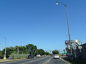
.jpg)
.jpg)
Highway 578 | ||||
|---|---|---|---|---|
| Ruta 578 | ||||
| Avenida José de Diego | ||||
 PR-578 highlighted in red | ||||
| Route information | ||||
| Maintained by Puerto Rico DTPW | ||||
| Length | 0.8 km[1] (0.50 mi; 2,600 ft) | |||
| Major junctions | ||||
| West end | PR-1 in Bucaná–Sabanetas | |||
| East end | Calle Húcar in Vayas–Sabanetas | |||
| Location | ||||
| Country | United States | |||
| Territory | Puerto Rico | |||
| Municipalities | Ponce | |||
| Highway system | ||||
| ||||
Major intersections
The entire route is located in Ponce.
 PR-1 east at its junction with PR-578
.jpg)
| Location | km[1] | mi | Destinations | Notes | |
|---|---|---|---|---|---|
| Bucaná–Sabanetas line | 0.8 | 0.50 | Western terminus of PR-578; no access to PR-1 eastbound; no access from PR-1 | ||
| Sabanetas–Bucaná– Vayas tripoint | 0.1– 0.0 | 0.062– 0.0 | |||
| Vayas–Sabanetas line | 0.0 | 0.0 | PR-Calle Húcar – Ponce | Eastern terminus of PR-578 | |
| 1.000 mi = 1.609 km; 1.000 km = 0.621 mi | |||||
See also
References
External links
Wikiwand - on
Seamless Wikipedia browsing. On steroids.