Top Qs
Timeline
Chat
Perspective
West Jersey
English possession in North America (1674–1702) From Wikipedia, the free encyclopedia
Remove ads
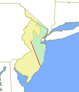
West Jersey and East Jersey were two distinct parts of the Province of New Jersey. The political division existed for 28 years, between 1674 and 1702. Determination of an exact location for a border between West Jersey and East Jersey was often a matter of dispute.
Remove ads

Remove ads
Background
Summarize
Perspective
The Delaware Valley had been inhabited by the Lenape (or Delaware) Indians prior to European exploration and settlement starting around 1609, undertaken by the Dutch, Swedish and English. The Dutch West India Company had established one or two Delaware River settlements, but by the late 1620s, it had moved most of its inhabitants to the island of Manhattan. This became the center of New Netherland.[1] West Jersey and East Jersey were two sections of New Jersey.
The development of the colony of New Sweden in the lower Delaware Valley began in 1638. Most of the Swedish population was on the west side of the Delaware. After the English re-established New Netherland's Fort Nassau to challenge the Swedes, the latter constructed Fort Nya Elfsborg in present-day Salem County. Fort Nya Elfsborg was located between present day Salem and Alloway Creek. The New Sweden colony established two primary settlements in New Jersey: Sveaborg, now Swedesboro, and Nya Stockholm, now Bridgeport. Trinity Church, located in Swedesboro, was the site of the Church of Sweden for the area.[2][3]
The Dutch defeated New Sweden in 1655. Settlement of the West Jersey area by Europeans was thin until the English conquest in 1664. Beginning in the late 1670s, Quakers settled in great numbers in this area, first in present-day Salem County and then in Burlington. The latter became the capital of West Jersey.[4]
Before 1674, land surveyors for New Jersey considered it as a hundred and partitioned it into tenths. West Jersey comprised five of the tenths. But demarcation of the boundaries awaited settlement, the quit-rents the settlers would pay, and the land surveying which the money would purchase. Thus it took years and multiple surveys to settle boundary disputes. Burlington County was formed on May 17, 1694 by combining the first and second tenths.[5] At least three surveys were conducted of West Jersey. Richard Tindall was surveyor-general of Fenwick's Colony, the fifth tenth.
Remove ads
Constitution
See also
References
Further reading
External links
Wikiwand - on
Seamless Wikipedia browsing. On steroids.
Remove ads

