Poston Butte
Landform in Pinal County, Arizona From Wikipedia, the free encyclopedia
Poston Butte, formerly called Primrose Hill, is a hill located along Hunt Highway in Florence, Pinal County, Arizona, United States,[3] near the eastern end of the Santan Mountains.[4] Geologically, it is characterized by basalts overlying altered granite.[5]
| Poston Butte | |
|---|---|
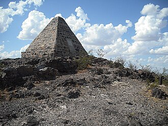
 Poston Butte, with Poston's pyramidal tomb at the peak | |
| Highest point | |
| Elevation | 1,749 ft (533 m) NAVD 88[1] |
| Prominence | 223 ft (68 m)[2] |
| Coordinates | 33°03′19″N 111°24′32″W[1] |
| Geography | |
 Poston Butte  Poston Butte | |
| Location | Pinal County, Arizona, U.S. |
| Topo map | USGS Florence |
This hill is noted for having the pyramidal tomb of Charles Debrille Poston at its summit. Poston lobbied President Lincoln and Congress to create the Territory of Arizona[6] and was appointed Superintendent of Indian Affairs because of his familiarity with the Native populations of the area.[7] The tomb can be accessed by a 0.6-mile (0.97 km) trail starting from the trailhead near Hunt Highway.[8]
 Tomb of Charles D. Poston
 Inscription on Poston's tomb


References
Wikiwand - on
Seamless Wikipedia browsing. On steroids.