Pogoanele
Town in Buzău, Romania From Wikipedia, the free encyclopedia
Pogoanele (Romanian pronunciation: [poˈɡo̯anele]) is a town in the southeastern part of Buzău County, Muntenia, Romania. The town administers one village, Căldărăști.
Pogoanele | |
|---|---|
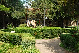
 Pogoanele Town Hall | |
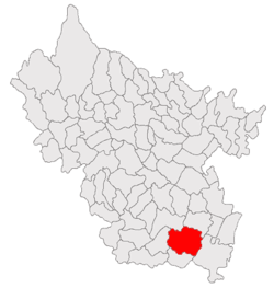
 Location in Buzău County | |
| Coordinates: 44°55′N 27°0′E | |
| Country | Romania |
| County | Buzău |
| Government | |
| • Mayor (2020–2024) | Florin Dumitrașcu[1] (PSD) |
Area | 122 km2 (47 sq mi) |
| Elevation | 63 m (207 ft) |
| Population (2021-12-01)[2] | 6,384 |
| • Density | 52/km2 (140/sq mi) |
| Time zone | EET/EEST (UTC+2/+3) |
| Postal code | 125200 |
| Area code | (+40) 02 38 |
| Vehicle reg. | BZ |
| Website | www |
Pogoanele was declared a town in April 1989, as a result of the Romanian rural systematization program.[3] It is located in the south-central part of the county, in the middle of the Bărăgan Plain, at about 40 kilometres (25 mi) from Buzău, the county seat. It is traversed by the DN2C road, which runs from Buzău to Slobozia. The railway station (3 kilometres (1.9 mi) from the town center) is on the CFR line connecting Urziceni and Făurei.
Natives of the town include Ion A. Rădulescu-Pogoneanu and Ilie Stan.
| Year | Pop. | ±% |
|---|---|---|
| 1992 | 7,768 | — |
| 2002 | 7,795 | +0.3% |
| 2011 | 7,275 | −6.7% |
| 2021 | 6,384 | −12.2% |
| Source: Census data | ||
Notes
Wikiwand - on
Seamless Wikipedia browsing. On steroids.


